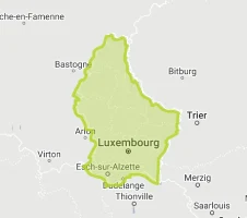
Luxembourg
World Rank: #168
2,586 km²
Next Larger Country
(Rank #167)
Mauritius
2,040 km²

Next Smaller Country
(Rank #169)
Samoa
2,842 km²
Luxembourg: Europe’s Powerful Microstate
Luxembourg ranks as the 168th largest country in the world with a territory of just 2,586 square kilometers (998 square miles). Nestled between France, Germany, and Belgium in Western Europe, Luxembourg occupies a strategic position at the heart of the European Union, making it far more significant than its modest dimensions might suggest.
What makes Luxembourg geographically remarkable is its outsized economic and political influence relative to its tiny footprint. This microstate packs impressive economic power into an area roughly the size of Rhode Island or one-quarter the size of Los Angeles County.
Located between latitudes 49° and 51° North, Luxembourg experiences minimal distortion on standard Mercator projection maps. The common perception of Luxembourg’s size is generally accurate, though its small dimensions sometimes lead to its exaggeration on European maps for visibility.
Let’s explore how Luxembourg’s true size compares to other regions and what makes this small but mighty nation geographically unique despite being one of Europe’s smallest countries.
Watch Luxembourg shrink to its actual size as we move it toward the equator. We compare it to the USA, Europe, Africa, Greenland, Brazil, Australia, Russia, India, China, etc. You can use this country size comparison interactive map here.
Luxembourg’s True Size in Global Perspective
To better understand Luxembourg’s dimensions, direct comparisons with other regions provide valuable context:
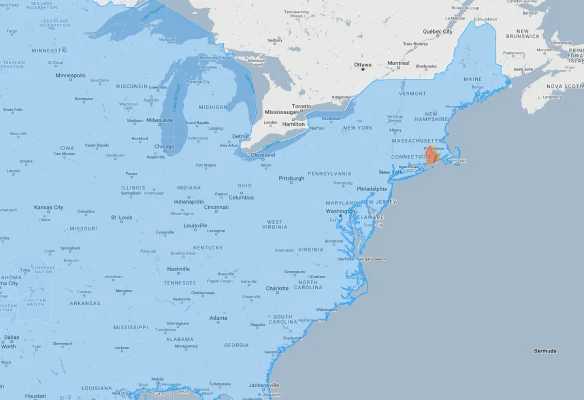
Luxembourg vs. US States: Luxembourg is roughly 65% the size of Rhode Island (the smallest US state) and about 1/160 the size of California
| Comparison | Flag | Area (km²) | Size Relative to Luxembourg |
|---|---|---|---|
| Luxembourg | |
2,586 | 1.0 |
| France |  |
551,695 | 213.3 times Luxembourg’s size |
| Germany |  |
357,022 | 138.1 times Luxembourg’s size |
| Switzerland |  |
41,285 | 16.0 times Luxembourg’s size |
| Belgium |  |
30,528 | 11.8 times Luxembourg’s size |
| Saarland (German state) | 2,570 | 0.99 times Luxembourg’s size | |
| Rhode Island (US state) |  |
4,001 | 1.55 times Luxembourg’s size |
| Canton of Valais (Swiss canton) | 5,224 | 2.02 times Luxembourg’s size | |
| Moselle Department (French department) | |
6,216 | 2.40 times Luxembourg’s size |
| London (UK) |  |
1,572 | 0.61 times Luxembourg’s size |
6 Surprising Luxembourg Size Comparisons
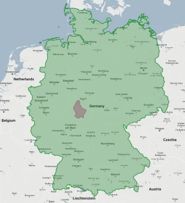
- Luxembourg vs. Germany: Germany is approximately 138 times larger than Luxembourg – you could fit Luxembourg into Germany 138 times.
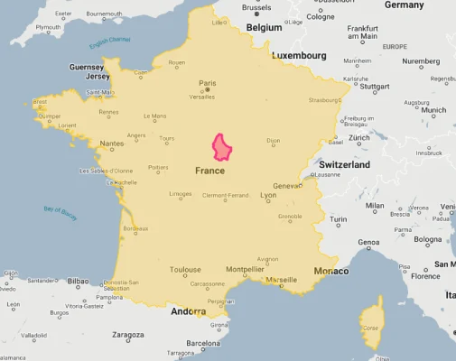
- Luxembourg vs. France: France is about 213 times larger than Luxembourg – its neighbor to the west could contain Luxembourg more than 200 times.
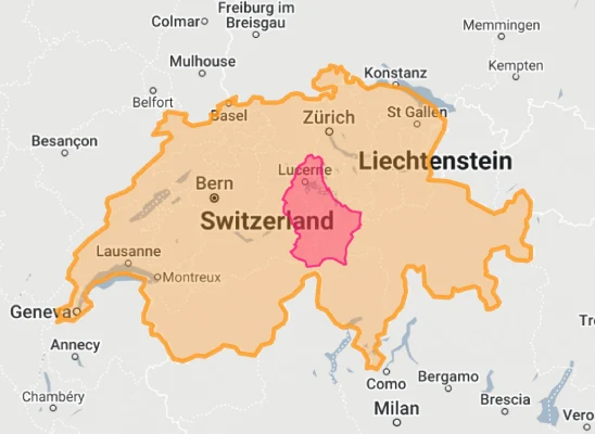
- Luxembourg vs. Switzerland: Switzerland is 16 times larger than Luxembourg, despite both being small European countries often compared for their wealth and banking sectors.
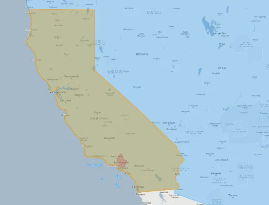
- Luxembourg vs. Los Angeles: The city of Los Angeles (not including the greater metropolitan area) is about 1.5 times larger than the entire country of Luxembourg.
- Luxembourg vs. Belgium:
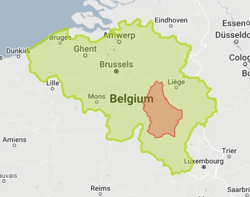
Luxembourg’s Geographic Features: Small but Varied
Despite its small size, Luxembourg contains notable geographic diversity:
- Oesling: The northern third of the country is part of the Ardennes plateau, characterized by hills and low mountains reaching up to 560 meters (1,837 feet) at Kneiff, the country’s highest point
- Gutland: The central and southern two-thirds of the country feature gently rolling hills, forests, and agricultural lands
- Moselle Valley: The eastern border follows the Moselle River, creating a picturesque valley known for its vineyards
- Red Lands (Terres Rouges): The southern industrial region, named for its iron-rich red soil, formerly home to Luxembourg’s steel industry
- Luxembourg City: The capital is dramatically situated on high bluffs intersected by the deep valleys of the Alzette and Pétrusse rivers, creating a natural fortress
Borders and Neighbors: Surrounded by European Powers
Luxembourg’s borders reflect its history at the crossroads of European powers:
- Luxembourg shares 359 kilometers (223 miles) of borders with three countries
- The border with Belgium stretches 148 kilometers (92 miles) to the west and north
- The border with Germany extends 138 kilometers (86 miles) to the east
- The border with France runs 73 kilometers (45 miles) to the south
- The country has no coastline, with the North Sea being the closest body of water, approximately 320 kilometers (200 miles) to the north
Population Distribution: Europe’s Most Densely Populated Sovereign State
Luxembourg’s compact territory supports a highly concentrated population:
- With approximately 650,000 people, Luxembourg has an average population density of about 248 people per square kilometer
- Luxembourg City, the capital, hosts about 125,000 residents, roughly 20% of the country’s total population
- An additional 200,000+ cross-border workers commute into Luxembourg daily from France, Belgium, and Germany, effectively increasing the daytime population by more than 30%
- Population is concentrated in the central and southern regions, particularly around Luxembourg City and the southern industrial areas
- The northern Oesling region is more sparsely populated, with numerous small towns and villages
Luxembourg’s Administrative Divisions: Cantons and Communes
Luxembourg’s administrative organization divides its small territory hierarchically:
| Administrative Division | Area (km²) | Comparable Area |
|---|---|---|
| Luxembourg District | 933 | San Marino (61 km²) |
| Diekirch District | 1,156 | Hong Kong (1,104 km²) |
| Grevenmacher District | 497 | Andorra (468 km²) |
| Luxembourg Canton | 238 | Liechtenstein (160 km²) |
| Luxembourg City (commune) | 51.6 | Manhattan, New York (59.1 km²) |
Climate and Geography: Mild Continental
Luxembourg’s climate reflects its position in Western Europe:
- The country has a temperate climate with mild summers and cool winters
- Average summer temperatures range from 15°C to 25°C (59°F to 77°F)
- Average winter temperatures typically range from -1°C to 4°C (30°F to 39°F)
- Annual precipitation averages around 850mm (33 inches), distributed relatively evenly throughout the year
- Microclimates exist within the small territory, with the Moselle valley being slightly warmer and drier than the higher Ardennes plateau in the north
Strategic Position: Crossroads of Western Europe
Luxembourg’s location has given it outsized historical and strategic importance:
- Located at the historical crossroads between Germanic and Latin Europe
- The natural fortress of Luxembourg City (now a UNESCO World Heritage site) was once known as the “Gibraltar of the North” for its strategic defensive position
- Luxembourg was a founding member of the European Union and hosts several key EU institutions, including the European Court of Justice
- The country has historically served as a buffer state between France and Germany
- Today, its central location in Western Europe makes it an important financial, administrative, and logistical hub
Economic Geography: Banking, Steel, and Services
Luxembourg’s economic landscape reflects its history and strategic positioning:
- Banking and Finance: Luxembourg City hosts over 140 banks and is one of the world’s leading financial centers despite the country’s tiny size
- European Institutions: The Kirchberg Plateau in Luxembourg City is home to several European Union institutions, including parts of the European Parliament, the European Court of Justice, and the European Investment Bank
- Industrial Heritage: The southern “Red Lands” region was historically dominated by the steel industry, which remains significant though less dominant
- Transportation Hub: Luxembourg’s central location makes it an important logistics center, with Luxembourg Airport serving as a major cargo hub
- Cross-Border Economy: Luxembourg’s economic influence extends well beyond its borders, with nearly half of its workforce commuting from neighboring countries
Natural Resources: From Iron to Intelligence
Luxembourg’s resource profile has evolved significantly:
- Iron ore was historically the country’s most important natural resource, supporting a major steel industry in the south
- Forests cover approximately 34% of the country’s territory, providing timber and recreational space
- Agricultural land makes up about 50% of the territory, though agriculture contributes less than 1% to GDP
- Water resources are abundant, with numerous rivers and streams including the Moselle, Sauer, and Alzette
- Today, Luxembourg’s most valuable “resources” are its strategic location, legal framework, and human capital
Environmental Conservation: Green Heart of Europe
Luxembourg’s approach to its natural environment is notable:
- Nature parks include the Upper Sûre Natural Park, the Our Nature Park, and the Mullerthal Region (Luxembourg’s “Little Switzerland”)
- The country has successfully transitioned from heavy industry to a service-based economy, dramatically reducing environmental impacts
- Luxembourg was the first country in the world to make all public transportation free nationwide, helping reduce emissions
- Brownfield redevelopment in the former industrial south has transformed old steel mills into modern urban centers, notably in Belval
- Despite its small size, Luxembourg maintains a network of hiking and cycling trails totaling over 5,000 kilometers
Explore More Size Comparisons
Curious about how other European countries compare in true size? Check out these related articles:
- The True Size of Switzerland
- The Real Size of France
- The Real Size of Germany
- Complete List of Countries by True Size
Sources & Further Reading
- STATEC (National Institute of Statistics and Economic Studies). (2024). Geographic and Demographic Data.
- CIA World Factbook. (2024). Luxembourg.