Thailand
World Rank: #39
513,120 km²



Thailand: Southeast Asia’s Central Crossroads
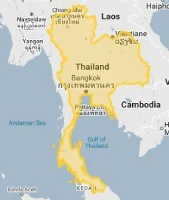
Thailand ranks as the thirty-ninth largest country in the world with a territory of 513,120 square kilometers (198,117 square miles). Occupying a central position in mainland Southeast Asia, Thailand bridges the Indochinese Peninsula with the Malay Peninsula, creating a geographic nexus that has contributed to its historical significance as a cultural and economic crossroads.
What makes Thailand geographically remarkable is its distinctive elongated shape, often compared to an elephant’s head with a long trunk extending south. This unique configuration creates extraordinary ecological diversity, from the mountainous highlands of the north to the fertile central plains and the tropical beaches of the southern peninsular region. This varied landscape has shaped Thailand’s development as one of Southeast Asia’s most economically and culturally vibrant nations.
Located between approximately 5° and 21° North latitude, Thailand experiences minimal distortion on standard Mercator projection maps. The country’s recognizable shape is accurately represented on most world maps, though its internal geographic diversity is often overlooked in global-scale representations.
Let’s explore how Thailand’s true size compares to other major countries and regions, and what makes this Southeast Asian nation geographically unique.
Watch Thailand expand its size as we move away from the equator. We compare it to the USA, Europe, Africa, Greenland, Brazil, Australia, Russia, India, China, etc. You can use this country size comparison interactive map here.
Thailand’s True Size in Global Perspective
To better understand Thailand’s dimensions, direct comparisons with other countries and regions provide valuable context:

Thailand vs. Western Europe: Thailand is comparable in size to Spain
| Comparison | Area (km²) | Size Relative to Thailand |
|---|---|---|
| Thailand | 513,120 | 1.0 |
| Spain | 505,990 | 0.99 times Thailand’s size |
| France | 551,695 | 1.08 times larger |
| California (US state) | 423,970 | 0.83 times Thailand’s size |
| Japan | 377,975 | 0.74 times Thailand’s size |
5 Surprising Thailand Size Comparisons
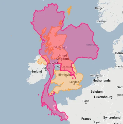
- Thailand vs. United Kingdom: Thailand is approximately 2.1 times larger than the United Kingdom (242,495 km²), offering a striking contrast between these two historically significant kingdoms.
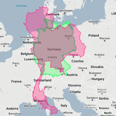
- Thailand vs. Germany: Thailand is approximately 1.4 times larger than Germany (357,022 km²), Europe’s most populous country.
- Thailand vs. California: Thailand is about 21% larger than California (423,970 km²), the third-largest U.S. state.

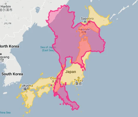
- Thailand vs. Japan: Thailand is 36% larger than Japan (377,975 km²), despite Japan having nearly twice Thailand’s population.
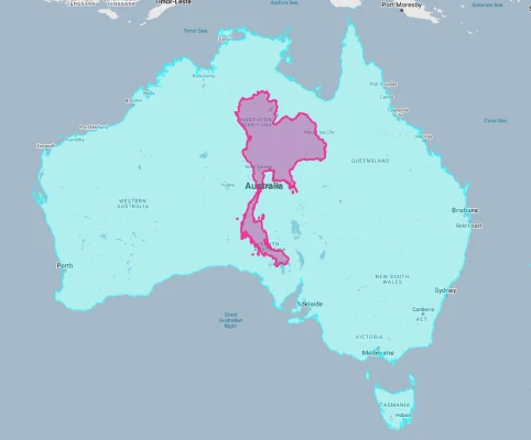
- Thailand vs. Australia:
Thailand’s Geographic Diversity: Four Distinct Regions
Thailand is traditionally divided into four major geographic regions, each with distinctive landscapes:
- Northern Thailand: A mountainous region with peaks exceeding 2,500 meters (8,200 feet), including Thailand’s highest point, Doi Inthanon (2,565 meters/8,415 feet)
- Northeastern Thailand (Isan): A plateau region averaging 200 meters (650 feet) above sea level, characterized by gently rolling terrain
- Central Thailand: A vast, flat alluvial plain formed by the Chao Phraya River and its tributaries, constituting the country’s rice bowl
- Southern Thailand: A narrow peninsula extending 960 kilometers (600 miles) south, with coastlines on both the Andaman Sea and Gulf of Thailand
- Islands: Thailand includes hundreds of islands, particularly in the Andaman Sea and Gulf of Thailand, with Phuket being the largest
The Central Plains: Thailand’s Heartland
The central plains form the geographic and economic core of Thailand:
- This vast alluvial plain is formed by the Chao Phraya River and its tributaries, which fan out to create one of Asia’s most productive rice-growing regions
- The region encompasses approximately 30% of Thailand’s territory but contains about 40% of its population
- Bangkok, Thailand’s capital and primate city, is located in the southern part of this region near the Gulf of Thailand
- The Chao Phraya River system includes complex water management infrastructure dating back centuries, including canals (khlongs) that once earned Bangkok the nickname “Venice of the East”
- The region’s flat terrain, fertile soil, and abundant water resources have made it Thailand’s agricultural and population center throughout history
Population Distribution: Concentrated Center
Thailand’s population distribution shows distinct patterns:
- With approximately 70 million people, Thailand has a moderately high average population density of about 136 people per square kilometer
- This density varies dramatically, with Bangkok’s metropolitan area exceeding 3,600 people per square kilometer, while some mountainous and border regions have fewer than 40 people per square kilometer
- About 51% of Thais live in urban areas, with urbanization increasing steadily
- The greater Bangkok metropolitan area houses over 15 million people – about 22% of the country’s population
- Population is generally concentrated in the central plains, along major rivers, and in provincial centers, with lower densities in mountainous and border regions
Thailand’s Provinces: Some Comparable to European States
Thailand is divided into 76 provinces (changwat) plus the special administrative area of Bangkok:
| Thai Province | Area (km²) | Comparable Country/Territory |
|---|---|---|
| Nakhon Ratchasima | 20,494 | Israel (20,770 km²) |
| Chiang Mai | 20,107 | Slovenia (20,273 km²) |
| Tak | 16,406 | Kuwait (17,818 km²) |
| Kanchanaburi | 19,483 | New Jersey, USA (19,211 km²) |
| Ubon Ratchathani | 15,745 | East Timor (14,874 km²) |
Geography and Climate: Tropical Variations
Thailand’s diverse topography creates several climatic zones:
- Thailand has a predominantly tropical climate governed by monsoon seasons, with high temperatures year-round in most regions
- The country experiences three distinct seasons: the cool season (November-February), the hot season (March-May), and the rainy season (June-October)
- Average temperatures range from 22-32°C (72-90°F) in the cool season to 29-38°C (84-100°F) in the hot season
- Annual rainfall varies dramatically by region, from 1,200 mm (47 inches) in some inland areas to over 4,000 mm (157 inches) in parts of the southern peninsula
- The northern mountainous regions experience cooler temperatures, with occasional near-freezing conditions at higher elevations during the cool season
International Borders: The Indochinese Hub
Thailand occupies a central position in mainland Southeast Asia:
- Thailand shares borders with four countries: Myanmar (2,416 km), Laos (1,845 km), Cambodia (817 km), and Malaysia (506 km)
- This central position has historically made Thailand a cultural and commercial crossroads between various Southeast Asian civilizations
- Major rivers, including the Mekong, form natural boundaries with neighboring countries and serve as important transportation routes
- Mountain ranges along many of Thailand’s borders have historically limited cross-border interactions and helped preserve Thai cultural independence
- Thailand serves as a key transit country in the Greater Mekong Subregion, with major transportation corridors connecting China to Malaysia and Singapore
Water Geography: Rivers and Coasts
Water features prominently in Thailand’s geographic identity:
- Thailand has approximately 3,219 kilometers (2,000 miles) of coastline, with the western coast facing the Andaman Sea and the eastern and southern coasts facing the Gulf of Thailand
- The Chao Phraya River system drains about 35% of Thailand’s territory, flowing through the central plains to the Gulf of Thailand
- The Mekong River forms much of Thailand’s eastern border with Laos and influences the hydrology of the northeastern region
- Thailand contains numerous large reservoirs and dams that support irrigation, flood control, and hydroelectric power generation
- The country’s extensive coastal waters and numerous islands support important fisheries, tourism, and shipping activities
Natural Resources: Diverse and Significant
Thailand’s varied territory contains diverse natural resources:
- Agricultural resources are significant, with Thailand being one of the world’s leading producers and exporters of rice, rubber, tropical fruits, and cassava
- Mineral resources include tin, gypsum, limestone, fluorite, and precious stones, though many deposits are becoming depleted
- Natural gas reserves in the Gulf of Thailand represent an important energy resource
- Forest resources, though reduced by historical deforestation, still cover approximately 32% of the country
- Marine resources along Thailand’s extensive coastline support major fishing and aquaculture industries
Geographic Hazards: Floods and More
Thailand’s geographic position exposes it to various natural hazards:
- Flooding: Seasonal monsoon rains and tropical storms frequently cause flooding, particularly in the central plains, as dramatically demonstrated by the 2011 floods
- Drought: Some regions, particularly the northeast, periodically experience drought conditions that affect agriculture and water supplies
- Landslides: Heavy rains in mountainous areas occasionally trigger destructive landslides
- Tropical Storms: Thailand’s coasts are vulnerable to tropical storms and typhoons, primarily affecting the southern peninsula and eastern coast
- Land Subsidence: Parts of Bangkok are experiencing significant subsidence due to groundwater extraction and the weight of urban development, creating increased vulnerability to flooding and sea-level rise
Explore More Size Comparisons
Curious about how other major countries and continents compare in true size? Check out these related articles:
- The True Size of Yemen: Arabia’s Mountainous Southern Gateway
- The True Size of Spain: Europe’s Second-Largest Country
- The True Size of Myanmar: Southeast Asia’s Hidden Geographic Giant
- The True Size of India
- Complete List of Countries by True Size
Sources & Further Reading
- National Statistical Office of Thailand. (2023). Statistical Yearbook Thailand.
- Department of National Parks, Wildlife and Plant Conservation. (2022). Geographic Profile of Thailand.
- CIA World Factbook. (2023). Thailand.