Cameroon
World Rank: #41
475,442 km²




Cameroon: Africa’s Ecological Giant in Miniature
Cameroon ranks as the forty-first largest country in the world with a territory of 475,442 square kilometers (183,569 square miles). Positioned at the crossroads of West and Central Africa, Cameroon’s distinctive triangular shape has earned it the nickname “Africa in miniature,” a reference to its remarkable ecological diversity that encapsulates nearly all of Africa’s major biomes within a single nation.
What makes Cameroon geographically remarkable is its extraordinary variety of landscapes and ecosystems. From the dense equatorial rainforests of the south to the savanna grasslands of the center and the arid Sahel region in the north, Cameroon contains an exceptional range of environments. Add to this the volcanic highlands of the west, with Mount Cameroon rising dramatically from the Gulf of Guinea coast to 4,070 meters (13,353 feet), and you have one of Africa’s most geographically diverse countries.
Located between approximately 2° and 13° North latitude, Cameroon experiences minimal distortion on standard Mercator projection maps. The country’s triangular shape is accurately represented on most world maps, though its internal geographic complexity is often underappreciated when viewed at the global scale.
Let’s explore how Cameroon’s true size compares to other major countries and regions, and what makes this Central African nation geographically unique.
Watch Cameroon expand its size as it moves away from the equator. We compare it to the USA, Europe, Africa, Greenland, Brazil, Australia, Russia, India, China, etc. You can use this country size comparison interactive map here.
Cameroon’s True Size in Global Perspective
To better understand Cameroon’s dimensions, direct comparisons with other countries and regions provide valuable context:
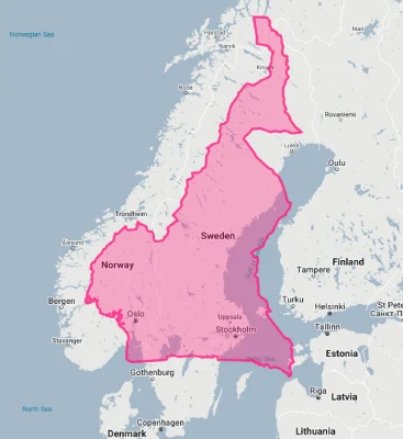
Cameroon vs. Western Europe: Cameroon is comparable in size to Sweden
| Comparison | Area (km²) | Size Relative to Cameroon |
|---|---|---|
| Cameroon | 475,442 | 1.0 |
| Sweden | 450,295 | 0.95 times Cameroon’s size |
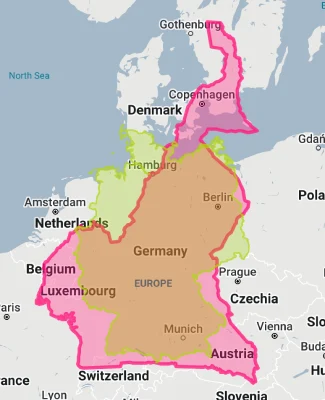
| Germany | 357,022 | 0.75 times Cameroon’s size |
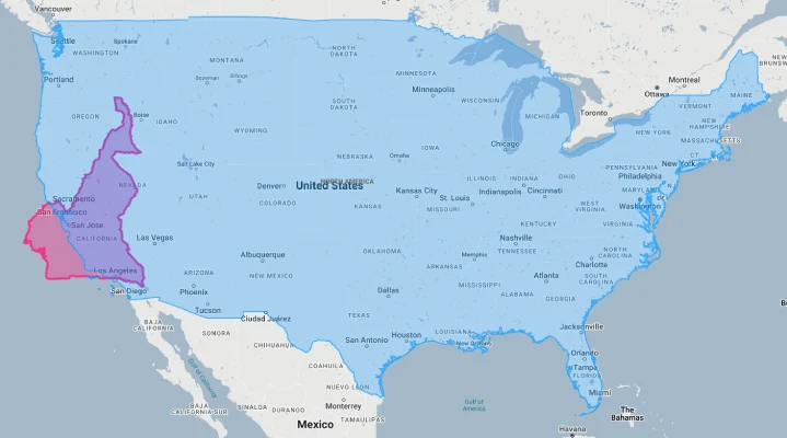
| California (US state) | 423,970 | 0.89 times Cameroon’s size |
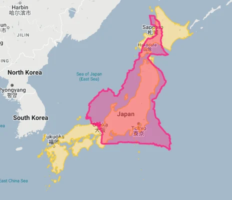
| Japan | 377,975 | 0.79 times Cameroon’s size |
5 Surprising Cameroon Size Comparisons
- Cameroon vs. United Kingdom: Cameroon is nearly twice the size of the United Kingdom (242,495 km²), yet receives far less international attention.
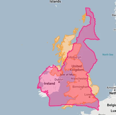
- Cameroon vs. Germany: Cameroon is approximately 1.3 times larger than Germany (357,022 km²), Europe’s most populous country.
- Cameroon vs. California: Cameroon is about 12% larger than California (423,970 km²), the third-largest U.S. state.
- Cameroon vs. Japan: Cameroon is 26% larger than Japan (377,975 km²), despite Japan having a population over six times larger.
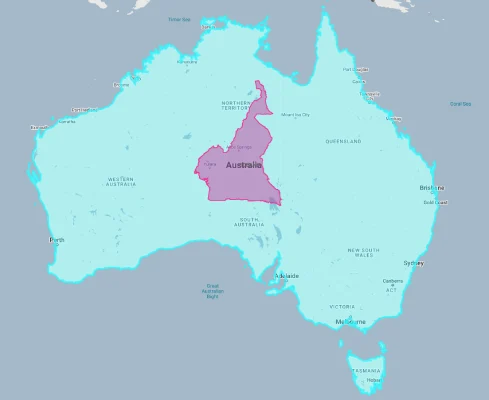
- Cameroon vs. Australia:
Cameroon’s Geographic Diversity: “Africa in Miniature”
Cameroon features an extraordinary variety of landscapes that justify its nickname:
- Volcanic Mountains: The Cameroon Volcanic Line runs from the Gulf of Guinea to the northern regions, creating a chain of volcanic mountains, including Mount Cameroon (4,070 meters/13,353 feet), the highest peak in West Africa
- Coastal Lowlands: A narrow coastal plain along the Gulf of Guinea with mangrove swamps and tropical beaches
- Tropical Rainforests: Dense equatorial forests in the south and southeast, part of the Congo Basin rainforest, the world’s second-largest tropical forest
- Central Plateau: An elevated plateau region (Adamawa Plateau) with mixed savanna and woodlands
- Northern Plains: Gradually descending plains transitioning to the semi-arid Sahel and Lake Chad Basin in the far north
Ecological Gradients: South to North
Cameroon’s elongated shape creates a remarkable ecological gradient:
- The country stretches approximately 1,200 kilometers (750 miles) from south to north, creating a transition through nearly all of Africa’s major biomes
- The southern regions receive up to 4,000 mm (157 inches) of annual rainfall and support dense equatorial rainforests
- The central regions feature wooded savannas and gallery forests with approximately 1,500 mm (59 inches) of annual rainfall
- The northern regions receive less than 600 mm (24 inches) of annual rainfall and transition to Sahel-type vegetation
- This ecological diversity makes Cameroon one of Africa’s most biodiverse countries, with over 9,000 plant species, 910 bird species, and 320 mammal species
Population Distribution: Regional Variation
Cameroon’s population distribution reflects its ecological diversity:
- With approximately 28 million people, Cameroon has a moderate average population density of about 59 people per square kilometer
- This density varies dramatically, with the western highlands having densities over 300 people per square kilometer, while parts of the eastern rainforest region have fewer than 5 people per square kilometer
- About 57% of Cameroonians live in urban areas, with urbanization increasing rapidly
- The two largest cities, Douala (economic capital) and Yaoundé (political capital), each house over 3 million people in their metropolitan areas
- Population is generally concentrated in the western highlands, the coastal region, and parts of the central plateau, with lower densities in the eastern rainforest and northern regions
Cameroon’s Regions: Some Comparable to European Countries
Cameroon is divided into 10 administrative regions, several of which are comparable in size to entire countries:
| Cameroon Region | Area (km²) | Comparable Country |
|---|---|---|
| East | 109,002 | Bulgaria (110,879 km²) |
| North | 66,090 | Lithuania (65,300 km²) |
| Adamawa | 63,701 | Latvia (64,589 km²) |
| South | 47,191 | Estonia (45,227 km²) |
| Far North | 34,263 | Moldova (33,846 km²) |
Geography and Climate: Tropical to Semi-Arid
Cameroon’s diverse topography creates distinct climatic zones:
- The southern coastal and rainforest regions have an equatorial climate with high rainfall (2,000-4,000 mm/79-157 inches annually) and consistent high temperatures (24-29°C/75-84°F)
- The western highlands have a modified tropical climate with cooler temperatures due to elevation and abundant rainfall, with some areas receiving over 3,000 mm (118 inches) annually
- The Adamawa Plateau has a tropical highland climate with moderate temperatures and a distinct dry season
- The northern regions have a Sudano-Sahelian climate with a long dry season (October to May) and a short rainy season, with annual rainfall decreasing to less than 600 mm (24 inches) in the far north
- The country experiences two main seasons in most regions: the rainy season and the dry season, though the timing and duration vary by latitude
International Borders: A Continental Crossroads
Cameroon occupies a strategic position at the crossroads of West and Central Africa:
- Cameroon shares borders with six countries: Nigeria (1,975 km), Chad (1,116 km), the Central African Republic (901 km), the Republic of the Congo (494 km), Gabon (349 km), and Equatorial Guinea (183 km)
- This central position has historically made Cameroon a cultural and commercial crossroads between different African regions
- The northern border includes part of Lake Chad, though the lake has significantly shrunk in recent decades
- The western border with Nigeria includes both mountainous highlands and coastal regions
- The eastern and southern borders cut through the Congo Basin rainforest, creating some of Africa’s least-developed frontier regions
Water Geography: Gulf Coast to Lake Chad
Water features prominently in Cameroon’s geography:
- Cameroon has approximately 402 kilometers (250 miles) of coastline along the Bight of Biafra, part of the Gulf of Guinea
- Major river systems include the Sanaga (the longest river entirely within Cameroon at 918 km/570 miles), Nyong, Wouri, and Logone
- The northern regions drain into Lake Chad, while the southern and eastern regions drain into the Atlantic Ocean either directly or via the Congo River system
- Several crater lakes exist in the western highlands, including Lake Nyos, notorious for a 1986 limnic eruption that released carbon dioxide and killed nearly 1,800 people
- The country contains significant wetland areas, including the Waza Logone floodplains in the north and coastal mangrove ecosystems
Natural Resources: Diverse and Significant
Cameroon’s varied territory contains diverse natural resources:
- Petroleum reserves, primarily offshore in the Gulf of Guinea, represent a significant energy resource
- Mineral resources include bauxite, iron ore, cobalt, nickel, manganese, and diamonds, though many deposits remain largely unexploited
- Forest resources are extensive, with tropical timber being a major export
- Agricultural resources include cocoa, coffee, cotton, rubber, bananas, and palm oil, with Cameroon being one of Africa’s leading agricultural producers
- Hydroelectric potential is substantial, particularly along the Sanaga River and in the western highlands
Geographic Hazards: Volcanic Activity and More
Cameroon’s geographic position exposes it to various natural hazards:
- Volcanic Activity: Mount Cameroon is one of Africa’s most active volcanoes, with eight eruptions recorded since 1900, most recently in 2000
- Toxic Lakes: Several crater lakes, including Lakes Nyos and Monoun, contain high levels of dissolved carbon dioxide that can be released in deadly limnic eruptions
- Flooding: Seasonal floods affect various regions, particularly the northern plains and coastal areas
- Drought: The northern regions periodically experience drought conditions, which have worsened in recent decades
- Landslides: The western highlands are susceptible to landslides during heavy rainfall, particularly in areas affected by deforestation
Explore More Size Comparisons
Curious about how other major countries and continents compare in true size? Check out these related articles:
- The True Size of Spain: Europe’s Southwestern Peninsula Giant
- The True Size of Papua New Guinea: Oceania’s Eastern Giant
- The True Size of Sweden: Northern Europe’s Forested Expanse
- The True Size of Nigeria: West Africa’s Population Powerhouse
- Complete List of Countries by True Size
Sources & Further Reading
- National Institute of Statistics, Cameroon. (2023). Statistical Yearbook.
- Ministry of Environment and Nature Protection. (2022). Biodiversity Profile of Cameroon.
- CIA World Factbook. (2023). Cameroon.