Papua New Guinea
World Rank: #42
462,840 km²




Papua New Guinea: Oceania’s Mountain-Jungle Giant
Papua New Guinea ranks as the forty-second largest country in the world with a territory of 462,840 square kilometers (178,704 square miles). Occupying the eastern half of New Guinea—the world’s second-largest island—plus numerous smaller islands, Papua New Guinea stands as the largest and most populous nation in the Pacific Islands region, often referred to as Oceania.
What makes Papua New Guinea geographically remarkable is its extraordinary topographical diversity and biological richness. Few countries can match PNG’s combination of rugged mountain ranges—with peaks exceeding 4,500 meters (14,800 feet)—dense tropical rainforests, extensive river systems, and intricate coastlines. This extreme geography has created one of Earth’s most linguistically and culturally diverse nations, with over 850 distinct languages spoken across its challenging terrain.
Located just south of the equator between approximately 1° and 12° South latitude, Papua New Guinea experiences minimal distortion on standard Mercator projection maps. The country’s distinctive shape, resembling a prehistoric bird with its head pointing westward, is accurately represented on most world maps, though its internal geographic complexity is often underappreciated when viewed at global scale.
Let’s explore how Papua New Guinea’s true size compares to other major countries and regions, and what makes this Pacific nation geographically unique.
Watch Papua New Guinea expand its size as we move it away from the equator. We compare it to the USA, Europe, Africa, Greenland, Brazil, Australia, Russia, India, China, etc. You can use this country size comparison interactive map here.
Papua New Guinea’s True Size in Global Perspective
To better understand Papua New Guinea’s dimensions, direct comparisons with other countries and regions provide valuable context:

Papua New Guinea vs. Western Europe: Papua New Guinea is comparable in size to Sweden
| Comparison | Area (km²) | Size Relative to Papua New Guinea |
|---|---|---|
| Papua New Guinea | 462,840 | 1.0 |
| Sweden | 450,295 | 0.97 times PNG’s size |
| Germany | 357,022 | 0.77 times PNG’s size |
| California (US state) | 423,970 | 0.92 times PNG’s size |
| Japan | 377,975 | 0.82 times PNG’s size |
5 Surprising Papua New Guinea Size Comparisons
- Papua New Guinea vs. United Kingdom: Papua New Guinea is nearly twice the size of the United Kingdom (242,495 km²), though receives far less international attention.

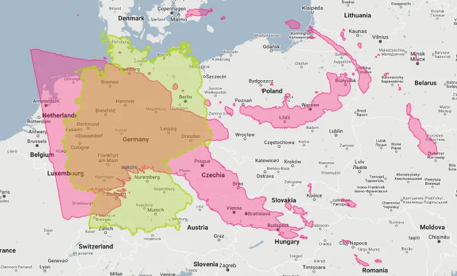
- Papua New Guinea vs. Germany: Papua New Guinea is approximately 1.3 times larger than Germany (357,022 km²), Europe’s most populous country.
- Papua New Guinea vs. California: Papua New Guinea is about 9% larger than California (423,970 km²), the third-largest U.S. state.

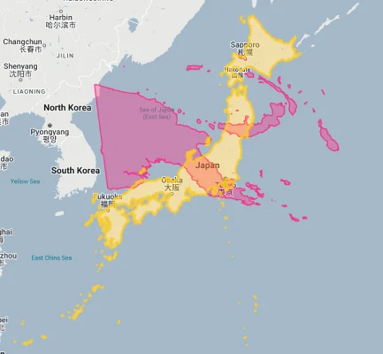
- Papua New Guinea vs. Japan: Papua New Guinea is 22% larger than Japan (377,975 km²), despite Japan having a population over twenty times larger.
- Papua New Guinea vs. Australia:

Papua New Guinea’s Geographic Diversity: Mountains to Reefs
Papua New Guinea features an extraordinary variety of landscapes:
- Central Highlands: A massive mountain spine runs east-west through the mainland, with several peaks exceeding 4,000 meters (13,000 feet) including Mount Wilhelm at 4,509 meters (14,793 feet), PNG’s highest point
- Tropical Rainforests: Dense rainforests cover approximately 74% of the country, making it the third-largest tropical forest area in the world after the Amazon and Congo basins
- Extensive River Systems: Major rivers include the Sepik, Fly, and Purari, which drain large areas and create vast floodplains and deltas
- Coastlines: Papua New Guinea has approximately 5,152 kilometers (3,201 miles) of coastline with numerous bays, peninsulas, and offshore islands
- Island Archipelagos: Beyond the mainland, PNG includes numerous island groups such as the Bismarck Archipelago (including New Britain and New Ireland), Bougainville, and the Louisiade Archipelago
The Highlands: PNG’s Geographic Backbone
The central highlands form the geographic core of mainland Papua New Guinea:
- This extensive mountain range runs approximately 1,600 kilometers (1,000 miles) along the length of the mainland, with elevations consistently above 2,000 meters (6,500 feet)
- The highlands contain numerous valleys, many densely populated with intensive agriculture on fertile volcanic soils
- This region features dramatic terrain variation, with some valleys only accessible by foot or air due to the extreme topography
- The highlands’ rugged nature has historically isolated communities, contributing to PNG’s extraordinary cultural and linguistic diversity
- Despite elevations that would typically create temperate conditions, the highlands’ equatorial location produces a constant “eternal spring” climate with average temperatures between 20-25°C (68-77°F) year-round at middle elevations
Population Distribution: Highland Density
Papua New Guinea’s population distribution reflects its challenging geography:
- With approximately 9.4 million people, Papua New Guinea has a relatively low average population density of about 20 people per square kilometer
- This density varies dramatically, with some highland valleys having densities over 200 people per square kilometer, while vast areas of lowland forest have fewer than 1 person per square kilometer
- Only about 13% of Papua New Guineans live in urban areas, one of the world’s lowest urbanization rates
- Port Moresby, the capital, houses approximately 400,000 people (metro area ~800,000) – less than 9% of the country’s population
- Population is generally concentrated in the highland valleys, coastal regions, and on some islands, with the interior lowland forests being among the least densely populated areas on Earth
Papua New Guinea’s Provinces: Some Comparable to European Countries
Papua New Guinea is divided into 22 provinces, several of which are comparable in size to smaller European countries:
| PNG Province | Area (km²) | Comparable Country |
|---|---|---|
| Western Province | 99,300 | Hungary (93,028 km²) |
| East Sepik | 43,426 | Denmark (43,094 km²) |
| Madang | 29,000 | Albania (28,748 km²) |
| Milne Bay | 16,202 | Montenegro (13,812 km²) |
| New Ireland | 9,557 | Cyprus (9,251 km²) |
Geography and Climate: Equatorial Variations
Papua New Guinea’s diverse topography creates distinct climatic zones:
- The lowland and coastal areas experience a tropical climate with high temperatures (24-32°C/75-90°F) and high humidity year-round
- The highlands have a cooler climate with average temperatures of 20-25°C (68-77°F) during the day and occasionally approaching freezing at the highest elevations at night
- Rainfall varies significantly, from 1,000 mm (39 inches) in some rain-shadow valleys to over 8,000 mm (315 inches) in parts of the southern slopes of the highlands, making PNG one of the world’s wettest countries
- Most regions experience wet and dry seasons rather than temperature-based seasons, with the timing varying by region due to different monsoon influences
- The country experiences the El Niño Southern Oscillation (ENSO) effect, with El Niño events bringing drought conditions to much of the country
International Borders: Sharing New Guinea Island
Papua New Guinea shares the island of New Guinea with Indonesia:
- The western half of New Guinea island is part of Indonesia (provinces of Papua and West Papua)
- The international border runs for 820 kilometers (510 miles) from north to south across the island, largely following the 141°E meridian with some adjustments
- This border was established during the colonial era, dividing ethnic groups and geographical features with little regard for traditional territorial boundaries
- The border region is largely remote and sparsely populated, with limited formal crossing points
- Papua New Guinea’s maritime borders bring it close to Australia to the south (with the Torres Strait Islands lying between) and the Solomon Islands to the east
Rivers and Wetlands: Flowing Giants
Papua New Guinea features some of the most significant river systems in Oceania:
- The Sepik River, PNG’s longest at 1,126 kilometers (700 miles), flows entirely within the country and is a cultural lifeline for numerous riverside communities
- The Fly River, at 1,050 kilometers (650 miles), creates an enormous delta system in the south and is navigable for much of its length
- These and other major rivers (Purari, Kikori, Ramu) transport enormous volumes of water and sediment, creating extensive floodplains and wetlands
- The country’s high rainfall and steep topography result in fast-flowing rivers that have substantial hydroelectric potential
- River systems have historically served as the primary transportation networks in many regions where roads are absent or limited
Natural Resources: Mineral Wealth and Biodiversity
Papua New Guinea’s varied territory contains diverse natural resources:
- Mineral resources are substantial, including gold, copper, silver, nickel, cobalt, and natural gas, making mining a key economic sector
- Forest resources cover nearly three-quarters of the country, with valuable tropical hardwoods, though these face pressures from logging
- Marine resources in PNG’s extensive territorial waters include significant fisheries, particularly tuna
- Biodiversity itself represents a unique resource, with an estimated 5-7% of the world’s biodiversity found within PNG’s borders
- Agricultural resources include cash crops such as coffee, cocoa, coconut, palm oil, and vanilla, grown in various climatic zones
Geographic Hazards: Volcanoes and More
Papua New Guinea’s geographic position exposes it to various natural hazards:
- Volcanic Activity: PNG has several active volcanoes, particularly in New Britain and Bougainville, with major eruptions occurring regularly
- Earthquakes: The country lies on the Pacific “Ring of Fire” and experiences frequent seismic activity, including major earthquakes
- Tsunamis: Coastal areas are vulnerable to tsunamis generated by undersea earthquakes, with a 1998 tsunami killing over 2,000 people
- Landslides: The combination of steep terrain, heavy rainfall, and seismic activity makes landslides a common hazard in highland areas
- Flooding: Intense rainfall events can cause flash flooding and riverine flooding, particularly in lowland areas
Biodiversity: An Evolutionary Laboratory
Papua New Guinea’s geographic isolation has created one of Earth’s most biodiverse regions:
- The country is estimated to contain between 5% and 7% of the world’s biodiversity in less than 1% of the world’s land area
- PNG hosts an estimated 20,000 species of vascular plants, 800 species of coral, 600 species of fish, 250 species of mammals, and 760 species of birds
- Endemism rates are extremely high, with many species found nowhere else on Earth, including tree kangaroos, birds of paradise, and numerous orchid species
- New species are regularly discovered, with scientific expeditions frequently finding plants and animals previously unknown to science
- This extraordinary biodiversity has evolved due to the country’s geographic isolation, tropical location, varied elevations, and complex geological history
Explore More Size Comparisons
Curious about how other major countries and continents compare in true size? Check out these related articles:
- The True Size of Cameroon: Africa’s Ecological Giant in Miniature
- The True Size of Sweden: Northern Europe’s Forested Expanse
- The Real Size of Japan: An Island Nation Larger Than Great Britain
- Complete List of Countries by True Size
Sources & Further Reading
- National Statistical Office of Papua New Guinea. (2023). Statistical Yearbook.
- Conservation International. (2022). Biodiversity Profile of Papua New Guinea.
- CIA World Factbook. (2023). Papua New Guinea.