New Zealand
World Rank: #75
268,021 km²

Next Larger Country
(Rank #74)
Gabon
267,667 km²

Next Smaller Country
(Rank #76)
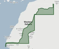
Western Sahara
266,000 km²
New Zealand: Bigger Than Britain, but Often Left Off Maps
New Zealand ranks as the 75th largest country in the world with a territory of 268,021 square kilometers (103,483 square miles). Despite being slightly larger than the United Kingdom and similar in size to Ecuador, this island nation is frequently underestimated in size and sometimes completely omitted from world maps, spawning the humorous r/MapsWithoutNZ subreddit and a national campaign to “#GetNZOnTheMap.”
What makes New Zealand geographically remarkable is not just its isolated position in the southwestern Pacific Ocean but its extraordinary diversity of landscapes compressed into a relatively compact area. From subtropical beaches and ancient forests in the north to alpine mountains and fjords in the south, New Zealand packs an astonishing range of environments into a country stretching just 1,600 kilometers (990 miles) from end to end.
Located between approximately 34° and 47° South latitude, New Zealand experiences moderate distortion on standard Mercator projection maps. While this distortion is less extreme than for countries closer to the poles, New Zealand’s position at the edge of many world maps means it’s often shrunk, misplaced, or entirely omitted—a cartographic injustice to a country that’s actually larger than Italy, the Philippines, or the UK.
Let’s explore New Zealand’s true size compared to other countries and regions, and what makes this island nation geographically distinctive despite its frequent cartographic neglect.
Watch New Zealand shrink to its actual size as we move it toward the equator. We compare it to the USA, Europe, Africa, Greenland, Brazil, Australia, Russia, India, China, etc. You can use this country size comparison interactive map here.
New Zealand’s True Size in Global Perspective
To better understand New Zealand’s dimensions, direct comparisons with other countries and regions provide valuable context:

New Zealand vs. Europe: New Zealand is larger than many European countries
| Comparison | Area (km²) | Size Relative to New Zealand |
|---|---|---|
| New Zealand | 268,021 | 1.0 |
| United Kingdom | 242,495 | 0.90 times New Zealand’s size |
| Italy | 301,340 | 1.12 times larger |
| Colorado (US state) | 269,837 | 1.01 times larger |
| Philippines | 300,000 | 1.12 times larger |
7 Surprising New Zealand Size Comparisons
- New Zealand vs. United Kingdom: New Zealand is approximately 10% larger than the United Kingdom (242,495 km²), a fact that surprises many given the UK’s greater global prominence.

- New Zealand vs. Japan: New Zealand is about 71% the size of Japan (377,975 km²), though it has less than 5% of Japan’s population.

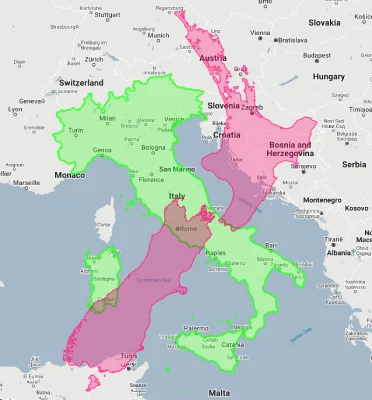
- New Zealand vs. Italy: New Zealand is about 89% the size of Italy (301,340 km²), with a shape that is coincidentally somewhat similar when rotated.
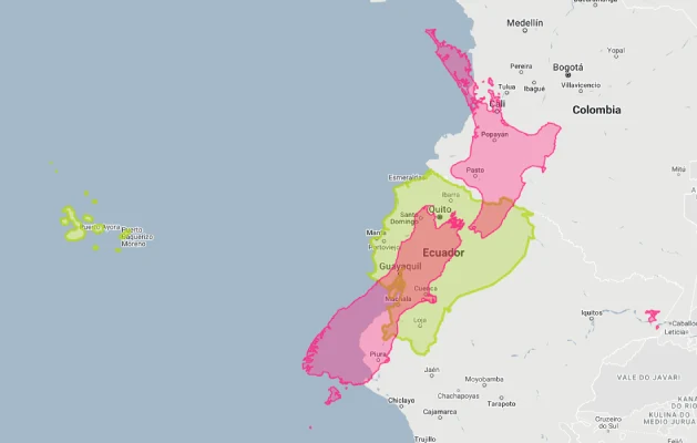
- New Zealand vs. Ecuador: New Zealand is slightly larger than Ecuador (256,369 km²), a country that straddles the equator and includes part of the Amazon rainforest.
- New Zealand vs. US East Coast: If placed along the U.S. East Coast, New Zealand would stretch from approximately Boston to South Carolina, covering multiple states.

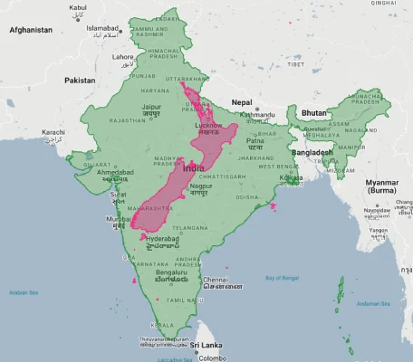
- New Zealand vs. India:
- New Zealand vs. Australia:

New Zealand’s Geographic Diversity: A World in Miniature
Despite its modest size, New Zealand features an extraordinary range of landscapes:
- Alpine Mountains: The Southern Alps run 500 kilometers (310 miles) along the South Island, with 23 peaks over 3,000 meters (9,800 feet), including Aoraki/Mount Cook at 3,724 meters (12,218 feet)
- Volcanic Landscapes: The North Island’s Taupo Volcanic Zone contains numerous active volcanoes, geothermal areas, and the world’s youngest supervolcano (Lake Taupo)
- Coastlines: New Zealand has approximately 15,000 kilometers (9,300 miles) of coastline with diverse formations including subtropical beaches, dramatic cliffs, and extensive fjords
- Native Forests: About 30% of New Zealand is covered in native forests, from subtropical kauri forests in the north to ancient beech forests in the south
- Glaciers: Despite its temperate climate, New Zealand contains over 3,000 glaciers, primarily in the Southern Alps, with Franz Josef and Fox Glaciers descending to just 300 meters (980 feet) above sea level
The Two Main Islands: North and South
New Zealand consists primarily of two main islands with distinct characters:
- The North Island (Te Ika-a-Māui) covers 113,729 square kilometers (43,911 square miles), about 42% of New Zealand’s land area
- The South Island (Te Waipounamu) is larger at 150,437 square kilometers (58,084 square miles), representing about 56% of the country’s land area
- The two main islands are separated by the Cook Strait, which is 22 kilometers (14 miles) wide at its narrowest point
- The North Island is characterized by volcanic activity, rolling hills, and a warmer climate, while the South Island features the dramatic Southern Alps, extensive plains, and a cooler climate
- Stewart Island/Rakiura, the third-largest island, covers 1,746 square kilometers (674 square miles) and lies 30 kilometers (19 miles) south of the South Island across Foveaux Strait
Population Distribution: Urban North, Rural South
New Zealand’s population distribution shows distinct patterns:
- With approximately 5.1 million residents, New Zealand has a low average population density of about 19 people per square kilometer
- About 77% of New Zealanders live on the North Island, despite it being smaller than the South Island
- Approximately 87% of New Zealanders live in urban areas, making it one of the most urbanized countries in the world
- The greater Auckland region in the North Island is home to approximately 1.7 million people—about one-third of the country’s population
- The South Island is much more sparsely populated, with large areas of mountains and national parks having essentially zero permanent residents
New Zealand’s Regions: Administrative Divisions
New Zealand is divided into 16 regions for local government purposes:
| New Zealand Region | Area (km²) | Comparable Entity |
|---|---|---|
| Canterbury (South Island) | 44,508 | Denmark (43,094 km²) |
| Southland (South Island) | 34,347 | Moldova (33,846 km²) |
| Otago (South Island) | 31,186 | Belgium (30,528 km²) |
| Waikato (North Island) | 25,000 | Macedonia (25,713 km²) |
| Auckland (North Island) | 4,894 | Trinidad and Tobago (5,130 km²) |
Geography and Climate: Temperate Variation
New Zealand’s geography creates distinct climate zones despite its relatively small size:
- New Zealand has a predominantly temperate maritime climate, though it varies significantly from subtropical in the far north to cool temperate in the south
- The country experiences moderate rainfall throughout the year, with western regions receiving significantly more precipitation than eastern areas due to the rain shadow effect of the mountain ranges
- Average temperatures range from 8°C (46°F) in July to 16°C (61°F) in January in Wellington (central New Zealand), with warmer temperatures in the north and cooler in the south
- The Southern Alps create dramatic climate differences between the west and east coasts of the South Island, with some western areas receiving over 7,000 mm (276 inches) of rain annually while eastern areas may receive under 600 mm (24 inches)
- Due to its position in the “Roaring Forties” wind belt of the Southern Hemisphere, New Zealand experiences strong westerly winds throughout much of the year
Geological Activity: The Shaky Isles
New Zealand’s position on the boundary of the Pacific and Australian tectonic plates creates an extremely active geological environment:
- The country experiences approximately 14,000 earthquakes annually, though only about 100-150 are strong enough to be felt
- The North Island’s Taupo Volcanic Zone contains numerous active volcanoes, including Mount Ruapehu, Mount Ngauruhoe, and White Island (Whakaari)
- Rotorua and surrounding areas feature extensive geothermal activity with geysers, hot springs, and bubbling mud pools
- The Alpine Fault, running nearly the entire length of the South Island, represents the boundary between the Pacific and Australian tectonic plates and produces major earthquakes approximately every 300 years
- This geological activity has shaped much of New Zealand’s distinctive landscape, from the volcanic cones of Auckland to the fjords of the South Island (created by glacial activity in terrain uplifted by tectonic forces)
Biodiversity: An Evolutionary Laboratory
New Zealand’s long isolation has created a unique biological environment:
- The country separated from the supercontinent Gondwana about 80 million years ago, allowing for the evolution of distinctive flora and fauna
- Before human arrival, New Zealand had no native land mammals except for bats, with birds evolving to fill ecological niches typically occupied by mammals elsewhere
- Approximately 80% of New Zealand’s plant species are endemic, meaning they are found nowhere else in the world
- Iconic native species include the flightless kiwi bird, the kakapo (the world’s only flightless parrot), the tuatara (a reptile unchanged since the dinosaur age), and the giant weta (one of the world’s heaviest insects)
- New Zealand’s extraordinary biodiversity, combined with its stunning and diverse landscapes, has made it a prime location for nature tourism and conservation efforts
Cartographic Injustice: The Country That’s Left Off Maps
New Zealand’s frequent omission from world maps has become a running joke and even prompted government action:
- The country is regularly left off world maps, with prominent examples including maps at the Smithsonian Natural History Museum, United Nations headquarters, Starbucks stores, and IKEA wall art
- This phenomenon spawned the popular subreddit r/MapsWithoutNZ, which documents instances of New Zealand’s cartographic erasure
- In 2018, Tourism New Zealand launched the humorous “#GetNZOnTheMap” campaign featuring Prime Minister Jacinda Ardern and comedian Rhys Darby investigating the “conspiracy” to delete New Zealand from world maps
- Experts suggest New Zealand’s omission stems from several factors: its position at the edge of most map projections, its relatively small population and economic footprint, and simple cartographic carelessness
- Ironically, this cartographic invisibility has actually increased global awareness of New Zealand’s location and true size through the humorous response to the phenomenon
Sources & Further Reading
- Stats NZ (Statistics New Zealand). (2023). New Zealand in Figures.
- Land Information New Zealand. (2022). New Zealand Geographic Information.
- CIA World Factbook. (2023). New Zealand.