Portugal
World Rank: #109
92,212 km² (35,603 sq mi)
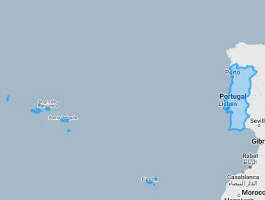

Next Smaller Country
(Rank #110)
Azerbaijan
86,600 km² (33,436 sq mi)
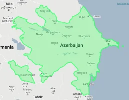
Portugal: Europe’s Atlantic Outpost Much Smaller Than You Think
Did you know Portugal and Indiana are almost exactly the same size? Or that Portugal has a larger Exclusive Economic Zone than the entire Indian subcontinent despite being smaller than most Indian states?
Welcome to the surprising dimensions of Portugal – a country whose small size belies its outsized historical global influence. Ranking 109th globally with just 92,212 square kilometers (35,603 square miles), Portugal is only 38% the size of the United Kingdom and a mere 18% the size of neighboring Spain. In fact, Portugal could fit inside Spain more than five times, yet historically dominated global maritime trade routes for centuries.
In this article, we’ll drag Portugal across the map to reveal how this modest Iberian nation truly measures up against other countries. Located between 37°N and 42°N latitude, Portugal experiences minimal map distortion on standard projections, meaning what you see is what you get – a relatively small, rectangular country hugging the westernmost edge of continental Europe.
Despite its limited dimensions, Portugal packs remarkable diversity into its territory, from the snow-capped Serra da Estrela mountains to golden beaches stretching along its 1,794-kilometer (1,115-mile) coastline. Most impressively, Portugal shares the longest uninterrupted border in Europe with Spain – a 1,214-kilometer (754-mile) frontier established in 1297 and virtually unchanged for over 700 years.
Here is how big Portugal actually is (video created with our interactive map that adjusts for Mercator projection distortion):
Watch how Portugal compares when overlaid on other countries. We’ve moved it across the USA, UK, Spain, Russia, and many other nations to reveal its true proportions. You can use this country size comparison interactive map here.
7 Mind-Blowing Portugal Size Facts
- Portugal is virtually identical in size to Indiana (92,212 km² vs. 94,326 km²)
- The country is just 38% the size of the United Kingdom but has 72% of the UK’s coastline
- Portugal fits inside Russia 195 times – you could fit two Portugals in just Moscow Oblast alone
- Portugal’s maritime territory is 18 times larger than its land area at 1.7 million km²
- The country is only 18% the size of Spain despite sharing the Iberian Peninsula
- Portugal would fit 105 times inside the United States – it’s smaller than 39 of the 50 US states
- Portugal once controlled an empire 23 times its own size (2.2 million km²) despite being smaller than Maine
Portugal’s True Size in Global Perspective
To appreciate Portugal’s actual dimensions, these direct comparisons with familiar regions offer eye-opening context:

Portugal vs. United Kingdom: Portugal is approximately 38% the size of the UK (92,212 km² vs. 242,495 km²)
| Comparison | Flag | Area (km²) | Size Relative to Portugal |
|---|---|---|---|
| Portugal | |
92,212 | 1.0 |
| United Kingdom |  |
242,495 | 2.63 times Portugal’s size |
| Spain |  |
505,990 | 5.49 times Portugal’s size |
| Indiana (US state) |  |
94,326 | 1.02 times Portugal’s size |
| Maine (US state) | |
91,646 | 0.99 times Portugal’s size |
| Hungary |  |
93,028 | 1.01 times Portugal’s size |
| Moscow Oblast (Russian province) |
 |
44,300 | 0.48 times Portugal’s size |
5 Astonishing Portugal Size Comparisons
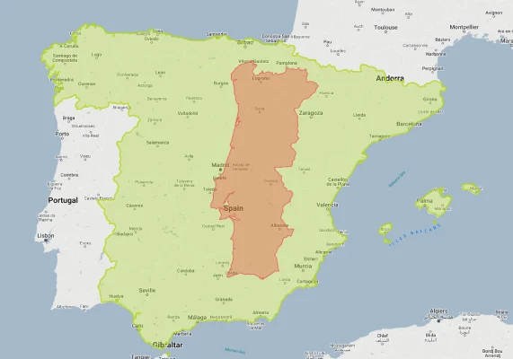
- Portugal vs. Spain: Perhaps the most striking comparison is between Portugal and its only land neighbor. Spain (505,990 km²) is a massive 5.5 times larger than Portugal (92,212 km²) despite sharing the same peninsula. This remarkable size difference – you could fit Portugal into Spain more than five times – creates one of Europe’s most disproportionate neighbor relationships. The Spanish autonomous community of Castile and León alone (94,226 km²) is larger than all of Portugal.
- Portugal vs. United Kingdom: Portugal (92,212 km²) is just 38% the size of the United Kingdom (242,495 km²), roughly equivalent to England minus its southern counties. This comparison helps explain the historical power imbalance between these two maritime nations – the UK simply had a much larger territorial base from which to project power. Despite this size discrepancy, Portugal maintains a coastline (1,794 km) that’s 72% as long as the UK’s entire coastline (12,429 km) thanks to its elongated shape and offshore islands.
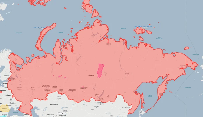
- Portugal vs. Russia: The size contrast between Portugal and Russia is truly staggering. Russia (17,098,246 km²) is approximately 185 times larger than Portugal. To put this in perspective, Portugal would fit inside Russia 185 times – you could place the entire country of Portugal inside just Moscow Oblast (44,300 km²) twice. This comparison dramatically illustrates the extraordinary range of national sizes – from Russia’s continental expanse to Portugal’s compact frame.
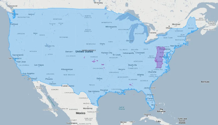
- Portugal vs. United States: The United States (9,833,517 km²) is approximately 107 times larger than Portugal. Portugal would fit into the continental US 105 times and is smaller than 39 of the 50 US states. In fact, Portugal is remarkably similar in size to Indiana (94,326 km²) and Maine (91,646 km²), providing Americans with perfect reference points. If placed over the eastern United States, Portugal would stretch roughly from New York City to Richmond, Virginia.
- Portugal vs. Its Former Empire: The most remarkable size comparison involves Portugal’s historical empire. At its peak in the early 1800s, Portugal controlled territories totaling approximately 2.2 million square kilometers across four continents – an empire roughly 24 times the size of the mother country. This created one of history’s most dramatic size disparities between a colonial power and its empire, with tiny Portugal controlling territories like Brazil (8.5 million km²) that dwarfed it by nearly 100-fold.
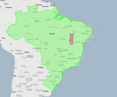
Portugal overlaid on Brazil.
Portugal’s Atlantic Significance: Maritime Scale From Limited Land
Portugal’s strategic location and maritime orientation create outsized significance:
The Western Gateway
Portugal occupies Europe’s westernmost position, serving as the continent’s Atlantic sentinel with continental Europe’s westernmost point at Cabo da Roca. This geographic placement gave Portugal extraordinary strategic significance as the first European country to face the open Atlantic, positioning it perfectly for the Age of Exploration. Portugal’s location at the nexus of Mediterranean-Atlantic trade routes allowed it to control access to the Mediterranean, creating outsized maritime importance from limited territorial dimensions.
The Island Extension
Though mainland Portugal is modest in size, the country includes the strategically valuable Azores and Madeira archipelagos, which extend Portuguese territory deep into the Atlantic. The Azores, located approximately 1,360 km (850 mi) west of mainland Portugal, provide crucial air and naval bases that effectively extend Portugal’s strategic reach far beyond its limited continental dimensions. These Atlantic islands create security, economic, and environmental advantages vastly disproportionate to their modest land area.
The Maritime Domain
Despite its modest land area, Portugal controls a vast maritime domain with an Exclusive Economic Zone of approximately 1.7 million square kilometers – roughly 18 times larger than its land territory and the 20th largest EEZ globally. This maritime expansion gives Portugal control over substantial marine resources and strategic waters disproportionate to its territorial size. Portugal’s maritime territory is larger than the combined EEZs of Germany, Belgium, the Netherlands, and Denmark.
The Continental Platform
Portugal is currently pursuing the expansion of its continental shelf under the United Nations Convention on the Law of the Sea, potentially extending its seabed rights to approximately 3.8 million square kilometers – more than 40 times its land area. This would make Portugal’s territory beneath the waves larger than India’s entire land mass, creating one of the world’s most dramatic ratios of underwater territory to land area and giving this small nation control over vast seabed resources and submarine terrain.
Portugal’s Geographic Diversity: Maximum Variety in Minimal Space
Portugal packs remarkable landscape diversity into its limited territory:
- Coastal Complexity: Despite its modest dimensions, Portugal boasts an impressive 1,794-kilometer (1,115-mile) coastline – 72% as long as the entire United Kingdom’s despite having just 38% of the UK’s area. This creates one of Europe’s highest coastline-to-area ratios, with approximately 19.5 meters of coast per square kilometer of territory (compared to the UK’s 8.2 meters or Spain’s 3.8 meters). This coastal wealth includes dramatic Atlantic cliffs in the Alentejo, extensive dune systems in the Centro region, and the sheltered beaches of the Algarve – creating exceptional maritime diversity within limited space.
- Mountain Ranges: Despite occupying just 92,212 square kilometers, Portugal contains 11 distinct mountain ranges, with the Serra da Estrela in central Portugal reaching 1,993 meters (6,539 feet) – high enough to support Portugal’s only ski resort. These mountains create dramatic elevational diversity, with approximately 40% of Portugal’s territory classified as mountainous or high plateau. This topographic variation produces remarkable landscape diversity, with subtropical coastal zones and alpine environments separated by distances of less than 150 kilometers in central Portugal.
- River Networks: Portugal’s modest territory contains portions of five major river basins, with the Douro, Tagus, and Guadiana rivers creating distinctive valley ecosystems. These rivers have carved dramatic landscapes, including the Alto Douro wine region – a UNESCO World Heritage site featuring the world’s oldest demarcated wine region established in 1756. The Tagus estuary near Lisbon is Europe’s largest, covering approximately 320 square kilometers – about 0.35% of Portugal’s entire territory in a single estuarine system.
- Biodiversity Hotspot: Portugal’s location at the intersection of Atlantic, Mediterranean, and Continental European climate zones creates exceptional biological diversity. Despite occupying just 0.06% of the world’s land area, Portugal contains approximately 29% of European butterfly species, 40% of European mammal species, and an estimated 3,500 plant species – approximately 25% of which are endemic to the Iberian Peninsula. Most notably, Portugal’s modest territory includes Europe’s last population of Iberian lynx – the world’s most endangered feline species.
- Islands and Archipelagos: Beyond its mainland, Portugal includes two significant Atlantic archipelagos: Madeira and the Azores. These island groups add approximately 3,259 square kilometers to Portugal’s territory while extending its maritime domain dramatically. Most remarkably, the Azores feature extraordinary ecological diversity, with the islands hosting 76 endemic plant species and Europe’s only tea plantations. The Azores also contain Portugal’s highest peak – Mount Pico (2,351 meters/7,713 feet) on Pico Island – exceeding any continental Portuguese mountain by over 350 meters.
Portugal’s Regions: Administrative Geography
Portugal is divided into 18 administrative districts plus 2 autonomous regions (Azores and Madeira):
| Portuguese Region | Area (km²) | Comparable To | Major City |
|---|---|---|---|
| Alentejo (largest region) |
31,605 | Slightly larger than Belgium (30,528 km²) | Évora |
| Centro | 28,199 | Similar to Albania (28,748 km²) | Coimbra |
| Norte | 21,278 | Slightly larger than Israel (20,770 km²) | Porto |
| Azores (autonomous region) |
2,333 | Similar to Luxembourg (2,586 km²) | Ponta Delgada |
| Madeira (autonomous region) |
801 | Similar to Singapore (728 km²) | Funchal |
| Lisbon Metropolitan Area | 3,015 | Similar to Rhode Island (4,001 km²) | Lisbon |
| Algarve (southernmost region) |
4,997 | Similar to Trinidad and Tobago (5,130 km²) | Faro |
Population Distribution: Coastal Concentration
Portugal’s 10.3 million inhabitants are distributed with distinctive patterns:
- With approximately 10.3 million residents across 92,212 square kilometers, Portugal maintains a moderate population density of 112 people per square kilometer (290 per square mile) – slightly higher than the European average of 101/km² but considerably lower than neighboring Spain (94/km²) and the United Kingdom (281/km²).
- Portugal’s population shows remarkable coastal concentration, with approximately 80% of residents living within 50 kilometers of the Atlantic Ocean. The two metropolitan areas of Lisbon and Porto alone contain nearly 45% of Portugal’s entire population despite occupying less than 8% of the national territory. This creates one of Europe’s most pronounced coastal demographic distributions in a country with limited territorial depth.
- The country’s interior regions face significant depopulation, with the Alentejo region (covering approximately 34% of mainland Portugal) having a population density of just 22.5 people per square kilometer – 20% of the national average and among the lowest in Western Europe. This interior-coastal population imbalance creates a situation where an area the size of Belgium contains fewer than 700,000 residents while coastal districts often exceed 300 people per square kilometer.
- Portugal exhibits marked north-south population distribution differences, with the Norte and Centro regions north of the Tagus River containing approximately 68% of the mainland population despite occupying just 54% of the mainland territory. This northern concentration stems from historical settlement patterns, more favorable agricultural conditions, and industrial development centered around Porto and Braga.
- Portugal’s autonomous island regions show distinctive population patterns, with Madeira maintaining a high density of 317 people per square kilometer while the Azores (106/km²) closely match the mainland average. The nine islands of the Azores create a diffuse population distribution spread across 2,333 square kilometers of land separated by 600 kilometers of ocean – one of Europe’s most dispersed regional populations.
The Border Paradox: Europe’s Oldest Yet Most Disputed Frontier
Portugal’s boundary with Spain creates a unique border situation:
- The Ancient Frontier: Portugal shares a 1,214-kilometer (754-mile) land border with Spain – the longest uninterrupted border within the European Union and one of the world’s oldest stable international boundaries. Established by the Treaty of Alcanizes in 1297, this border has remained largely unchanged for over 700 years – a remarkable stability outlasting most European borders by centuries. This creates the paradoxical situation where one of Europe’s smallest countries maintains one of its longest and oldest land borders.
- The Olivença Dispute: Despite its overall stability, Portugal’s border contains Europe’s oldest territorial dispute at Olivença/Olivenza – a 450-square-kilometer territory (approximately 0.5% of Portugal’s area) occupied by Spain since 1801 but still claimed by Portugal. This creates the unusual situation where one of Europe’s oldest borders contains its longest-running border dispute, with Portugal never formally recognizing Spanish sovereignty despite 220 years of de facto Spanish control.
- The Border Intensity: Portugal’s limited territorial dimensions combined with its 1,214-kilometer land border create one of Europe’s highest border-to-area ratios at approximately 13.2 meters of land border per square kilometer of territory – nearly triple Spain’s ratio of 4.5 meters per square kilometer. This high border intensity means international boundaries are never far away in Portugal, with the maximum distance to the Spanish border from any point in mainland Portugal being just 102 kilometers (63 miles).
- The River Boundaries: Approximately 640 kilometers (53%) of Portugal’s border with Spain follows rivers – primarily the Minho, Douro, Tagus, and Guadiana. These riverine boundaries create distinctive “international rivers” where opposite banks lie in different countries. Most notably, the final 110 kilometers of the Guadiana River forms an international border that has remained unchanged since 1297 – likely Europe’s oldest continuously maintained river boundary.
- The Couto Misto Anomaly: Until 1868, the Portuguese-Spanish border contained an extraordinary anomaly called Couto Misto – a self-governing microstate of approximately 30 square kilometers that was neither Portuguese nor Spanish. This peculiar territory functioned as an independent entity for over 700 years, with residents enjoying tax exemptions, freedom from military service, and other special privileges in a region smaller than modern San Marino.
Historical Geographic Impact: Limited Size, Global Reach
Portugal’s modest dimensions belied its outsized historical impact:
- Maritime Exploration Pioneer: From a territorial base smaller than Indiana, Portugal launched the European Age of Exploration, with navigators like Vasco da Gama, Ferdinand Magellan, and Bartolomeu Dias fundamentally transforming global geography. By 1500, this small nation had mapped previously unknown coastlines across Africa, Asia, and the Americas – effectively doubling the known world from a maritime base occupying just 0.06% of global land area.
- Disproportionate Colonial Empire: At its peak, Portugal controlled approximately 2.2 million square kilometers of overseas territory – roughly 24 times larger than Portugal itself. This created one of history’s most dramatic size disparities between a colonial power and its possessions. Most remarkably, Portugal controlled Brazil (8.5 million km²) – a territory 92 times Portugal’s size and nearly as large as all of Europe – for over three centuries despite being smaller than many Brazilian states.
- The Treaty of Tordesillas Effect: The 1494 Treaty of Tordesillas, negotiated primarily by Portugal and Spain, effectively divided the non-European world between these two Iberian powers. This agreement granted Portugal control of Brazil, Africa, and Asia – giving a country smaller than many US states claim to roughly half the “undiscovered” world and creating perhaps history’s most dramatic territorial overreach relative to home country size.
- Global Language Legacy: Despite its modest dimensions, Portugal established Portuguese as a global language now spoken by approximately 260 million people in nine countries across four continents. This linguistic footprint dramatically exceeds what would be expected from Portugal’s size, with Portuguese speakers outnumbering the population of Portugal by roughly 25 to 1 – one of the highest ratios of overseas language speakers to home country population.
- Territorial Resilience: Most remarkably, Portugal has maintained essentially unchanged European borders since 1297 despite being surrounded by a much larger neighbor (Spain) that unified all other Iberian territories. This territorial resilience – maintaining independence for over 800 years despite limited size – represents one of Europe’s most successful cases of small-state survival, with Portugal’s borders predating those of virtually all modern European states.
Modern Geographic Influence: Quality Over Quantity
Portugal’s limited size belies its continued global connections:
- Maritime Domain: Despite ranking just 109th in land area, Portugal controls the 20th largest Exclusive Economic Zone globally at approximately 1.7 million square kilometers – 18 times larger than its land territory. This maritime domain, combined with Portugal’s continental shelf extension claim of 3.8 million square kilometers, would give this small nation control over vast ocean resources disproportionate to its size. Portugal’s maritime territory exceeds that of much larger nations like India (2.3 million km²) and China (880,000 km²).
- Strategic Azores: Portugal’s sovereignty over the mid-Atlantic Azores archipelago gives this small country control of strategically crucial territory approximately 1,360 kilometers (850 miles) west of the mainland. The Lajes Air Base on Terceira Island serves as a key NATO facility, effectively extending Portuguese (and by extension, European) strategic reach deep into the Atlantic. This creates considerable strategic leverage from just 2,333 square kilometers of insular territory.
- Community of Portuguese Language Countries: Portugal maintains special relationships with seven former colonies through the Community of Portuguese Language Countries (CPLP), spanning four continents and 10.8 million square kilometers of territory – 117 times Portugal’s size. This organization encompasses approximately 260 million people and some of the world’s fastest-growing economies, creating global influence vastly disproportionate to Portugal’s modest dimensions.
- Renewable Energy Leadership: Portugal’s limited territory has become a global renewable energy leader, with the country frequently achieving 100% renewable electricity generation despite limited land area. In March 2018, Portugal generated 104% of its mainland electricity consumption from renewables – demonstrating how a country occupying just 0.06% of the world’s land area can achieve outsize environmental impact through efficient resource use.
- Diaspora Connections: Portugal maintains connections with approximately 5 million overseas Portuguese – roughly half the population of Portugal itself. This creates a global Portuguese presence vastly exceeding what would be expected from Portugal’s modest dimensions, with significant Portuguese communities in the United States (1.4 million), Brazil (1.2 million), France (600,000), and Canada (420,000) extending Portuguese cultural influence far beyond its limited territorial bounds.
Explore More Size Comparisons
Curious about how other major countries and regions compare in true size? Check out these related articles:
- Real Size Of Spain: 5.5 Times Larger Than Portugal But Smaller Than Texas
- Real Size Of United Kingdom: 94 Times Smaller Than Australia Yet Controls 6th Largest Economy
- Real Size Of France: Western European Nation Larger Than You Think
- Real Size Of Hungary: Smaller Than Indiana But With More Thermal Water Than Any Country In Europe
- Complete List of Countries by True Size
Sources & Further Reading
- Statistics Portugal (INE). (2024). Geographical Information and National Statistics.
- Portuguese Environment Agency. (2024). Environmental Data of Portugal.
- CIA World Factbook. (2024). Portugal.