Niger
World Rank: #18
1,267,000 km²





Niger: The Vast Saharan Giant Most People Can’t Place on a Map
Niger ranks as the eighteenth-largest country in the world with a territory of 1,267,000 square kilometers (489,191 square miles). This immense West African nation is the continent’s sixth-largest country, yet remains virtually unknown to most people outside Africa. What’s truly staggering is that Niger’s massive expanse would encompass France, Germany, Italy, and the United Kingdom combined—a landmass equivalent to the heart of Western Europe.
What makes Niger’s geography truly extraordinary is its position at the very heart of the Sahara Desert, with over 80% of its territory covered by arid desert landscapes. Despite this harsh environment, Niger straddles a crucial ecological transition zone between the Sahara proper and the somewhat more hospitable Sahel belt to the south, creating one of Africa’s most dramatic environmental gradients within a single country.
Located between approximately 12° and 23° North latitude, Niger experiences moderate distortion on standard Mercator projection maps. Its northern territories appear somewhat larger than they truly are, though less dramatically than countries at more extreme latitudes. This cartographic distortion, combined with limited global awareness, contributes to Niger’s underappreciated geographic significance.
Watch Niger shrink to its actual size as we move it toward the equator. We compare it to the USA, Europe, Africa, Greenland, Brazil, Australia, Russia, India, China, etc. You can use this country size comparison interactive map here.
Niger’s Unbelievable True Size Will Astound You: Global Perspective
To truly grasp Niger’s dimensions, these direct comparisons with familiar countries and regions provide eye-opening context:
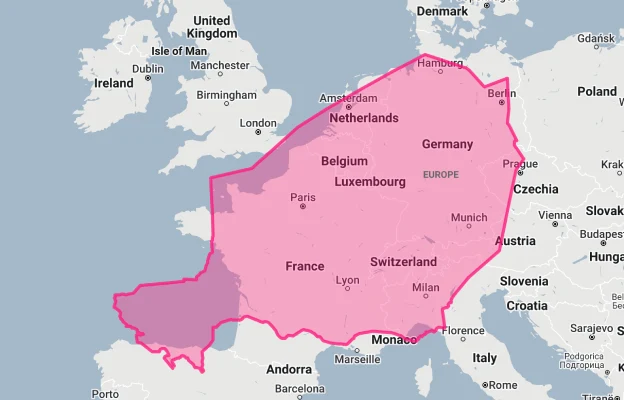
Niger vs. Western Europe: Niger would completely engulf several major European powers combined
| Comparison | Area (km²) | Size Relative to Niger |
|---|---|---|
| Niger | 1,267,000 | 1.0 |
| France, Germany, and Italy combined | ~1,065,000 | ~0.84 times Niger’s size |
| South Africa | 1,219,090 | 0.96 times Niger’s size |
| Texas and California combined (US states) | 1,099,807 | 0.87 times Niger’s size |
| Angola | 1,246,700 | 0.98 times Niger’s size |
5 Mind-Blowing Niger Size Comparisons You Never Imagined
- Niger vs. United States: Niger is nearly twice the size of Texas, America’s second-largest state. If placed over the eastern United States, it would stretch from New York to Georgia and west to Indiana.

- Niger vs. Western Europe: Niger could contain France, Germany, Italy, and Belgium combined—with room to spare for the Netherlands.
- Niger vs. Japan: Niger is approximately 3.4 times larger than Japan, despite Japan having a population over 120 times greater.

- Niger vs. India:

- Niger vs. Australia:

Niger’s Geographic Gradient: From Absolute Desert to Savanna
Niger’s geography creates a dramatic environmental progression from north to south:
- Saharan Zone: The northern two-thirds of Niger is dominated by the Sahara Desert, including the imposing Aïr Mountains, vast sand seas of the Ténéré Desert, and rocky plateaus of the Djado
- Sahel Belt: The central region forms part of the Sahel, a semi-arid transition zone between the Sahara and more fertile regions to the south
- Sudan Zone: The southernmost strip, particularly along the Niger River, receives enough rainfall to support agriculture and savanna vegetation
- Elevation Range: From 200 meters (656 feet) in the Niger River valley to 2,022 meters (6,634 feet) at Mount Idoukal-n-Taghès in the Aïr Mountains
- Landlocked: Niger is completely landlocked, with its closest point to an ocean being approximately 700 kilometers (435 miles) from the Atlantic
The Aïr Mountains: A Saharan Sky Island
The Aïr Mountains in northern Niger constitute a remarkable “island” of biodiversity in the Sahara:
- The Aïr range covers approximately 84,000 square kilometers (32,432 square miles)—an area larger than Austria
- Mount Idoukal-n-Taghès, Niger’s highest peak at 2,022 meters (6,634 feet), rises dramatically from the surrounding desert plains
- The mountains capture enough moisture to support specialized plant communities and wildlife that cannot survive in the surrounding desert
- The region contains numerous seasonal wadis (dry riverbeds) that briefly flow during rare rainfall events and sustain desert oases
- The mountains and surrounding areas contain remarkable prehistoric rock art dating back 6,000 to 8,000 years, depicting a time when the Sahara was green and supported diverse wildlife including giraffes, elephants, and crocodiles
The Ténéré Desert: One of Earth’s Most Extreme Environments
The Ténéré Desert in eastern Niger represents one of the most forbidding landscapes on Earth:
- The name “Ténéré” comes from the Tuareg language, meaning “desert within a desert”—a testament to its extreme aridity
- The region features vast sand seas (ergs) with dunes reaching heights of over 300 meters (980 feet)
- The iconic “Tree of Ténéré,” once considered the most isolated tree on Earth, stood alone in this desert for decades until it was knocked down by a truck in 1973
- Parts of the Ténéré may go several years without receiving any measurable rainfall
- Despite its current extreme aridity, the Ténéré contains evidence of ancient lakes and rivers, including fossils of crocodiles, fish, and other aquatic species from wetter periods thousands of years ago
The Niger River: Lifeblood of a Desert Nation
The Niger River forms a crucial lifeline for the country that bears its name:
- The Niger River flows for approximately 550 kilometers (340 miles) through southwestern Niger, forming part of the border with Benin
- Despite giving its name to the country, the river only passes through a small part of Niger’s territory
- The river creates a fertile band in an otherwise arid country, supporting agriculture, fishing, and transportation
- The Niger River’s unusual boomerang-shaped course begins just 240 kilometers (150 miles) from the Atlantic Ocean but flows away from it into the Sahara before turning southeast toward Nigeria
- The river valley supports the majority of Niger’s agriculture and contains most of the country’s largest cities, including the capital Niamey
Population Distribution: Extreme Southern Concentration
Niger’s population distribution shows one of the world’s most dramatic demographic imbalances:
- With approximately 25 million people, Niger has a very low average population density of about 20 people per square kilometer
- This density varies dramatically by region, with the northern Saharan zone having fewer than 1 person per square kilometer while some southern areas exceed 100 people per square kilometer
- About 90% of Niger’s population lives in the southernmost 35% of the country, where rainfall is sufficient for agriculture
- Niamey, the capital and largest city with about 1.3 million inhabitants, is home to just about 5% of the country’s population
- Niger has one of the highest population growth rates in the world at approximately 3.8% annually, with a fertility rate of about 7 children per woman—the highest in the world
Niger’s Regions: Large as European Nations
Many of Niger’s 8 regions (administrative divisions) are comparable in size to entire countries:
| Nigerien Region | Area (km²) | Comparable Country |
|---|---|---|
| Agadez | 667,799 | France (643,801 km²) |
| Tahoua | 113,371 | Bulgaria (110,994 km²) |
| Zinder | 155,778 | Bangladesh (147,570 km²) |
| Diffa | 156,906 | Tunisia (163,610 km²) |
| Tillabéri | 97,251 | Hungary (93,028 km²) |
Geography and Climate: Harsh Extremes
Niger’s desert location creates one of the world’s most challenging climates:
- Annual rainfall ranges from virtually zero in the far north to about 800 mm (31 inches) in the extreme southwest—a dramatic gradient across the country
- Niger is one of the hottest countries on Earth, with average daily maximum temperatures in the hottest months (April-June) exceeding 40°C (104°F) across much of the country
- The highest temperature ever recorded in Niger was 49.5°C (121.1°F) in Bilma, in the northeastern Ténéré Desert
- The harmattan, a dry, dust-laden wind from the northeast, dominates during the dry season (October to May), creating massive dust storms
- The brief rainy season (June to September) brings critical but highly variable precipitation to the southern regions, with drought being a recurrent threat
The Uranium Connection: Desert Treasure
Niger possesses one of Africa’s most significant mineral resources:
- Niger is the world’s seventh-largest producer of uranium, with major deposits in the northern Aïr region near the mining towns of Arlit and Akokan
- Uranium was discovered in Niger in 1957 by the French Bureau de Recherches Géologiques et Minières (BRGM)
- Mining operations began in 1971, and uranium has since been Niger’s most valuable export
- The uranium deposits are located in one of the country’s most remote and arid regions, creating extreme logistical challenges for extraction and transportation
- In recent years, Niger has begun to diversify its mineral exploitation to include gold, coal, and oil
Geographic Challenges: Battling the Desert
Niger’s geography creates some of the world’s most severe development challenges:
- Landlocked Position: Niger is severely disadvantaged by its landlocked position, with the nearest seaport (Cotonou, Benin) being approximately 1,000 kilometers (620 miles) away
- Drought: The country is extremely vulnerable to periodic droughts that can devastate agriculture and livestock herding, particularly in the Sahel region
- Desertification: Environmental degradation and climate change are accelerating desertification, with the Sahara advancing southward at an estimated rate of up to 10 kilometers (6.2 miles) per year in some areas
- Water Scarcity: Outside the Niger River valley, water resources are extremely limited and under increasing pressure from population growth and climate change
- Food Insecurity: The harsh climate creates chronic food insecurity, with approximately 80% of Niger’s population dependent on rain-fed agriculture in a region with highly variable rainfall
Cultural Adaptation: Living with the Desert
Niger’s diverse ethnic groups have developed remarkable adaptations to the harsh environment:
- The Tuareg people of northern Niger practice transhumance, moving their livestock seasonally to find pasture in the desert and mountainous regions
- The Wodaabe (Fulani) are known for their elaborate cultural ceremonies including the Gerewol, a male beauty contest and courtship ritual
- Traditional architecture in Niger uses thick mud walls, small windows, and courtyards to mitigate the extreme heat
- Agricultural practices have been adapted to maximize water conservation, including techniques like zai pits (small planting holes that concentrate scarce water and nutrients)
- Niger’s cultural geography reflects its position at the crossroads of Arabic, Berber, and sub-Saharan African influences, with distinctive regional variations
Explore More Size Comparisons
Curious about how other major countries and continents compare in true size? Check out these related articles:
- The Colossal Truth About Chad: Africa’s Hidden Giant Bigger Than All of Western Europe
- The Real Size of Angola: Southern Africa’s Atlantic Giant
- The Shocking True Size of Peru: Ancient Empire Hidden in Plain Sight
- The True Size of Africa: A Continent Far Larger Than Maps Suggest
- Complete List of Countries by True Size
Sources & Further Reading
- Institut National de la Statistique du Niger. (2023). Geographical and Statistical Data.
- CIA World Factbook. (2023). Niger.