Angola
World Rank: #19
1,246,700 km²




Angola: The Massive Southwest African Nation That Would Engulf Western Europe
Angola ranks as the nineteenth-largest country in the world with a territory of 1,246,700 square kilometers (481,354 square miles). This vast Southwest African nation is the continent’s seventh-largest country, yet remains poorly understood by most people outside Africa. What’s truly remarkable is that Angola’s massive expanse could contain France, Germany, and the United Kingdom combined—with room to spare for Portugal and Belgium, a fitting comparison given its colonial history.
What makes Angola’s geography extraordinary is its tremendous diversity, spanning from the arid Namib Desert in the southwest through the fertile central highlands to the lush rainforests of Cabinda and the northern regions. This environmental range is complemented by a 1,600-kilometer (994-mile) Atlantic coastline that gives Angola strategic maritime importance unmatched by many of its continental neighbors.
Located between approximately 4° and 18° South latitude, Angola experiences relatively little distortion on standard Mercator projection maps compared to countries at more extreme latitudes. However, its true scale and geographical significance remain underappreciated in global consciousness, partly due to limited international exposure during its long civil war (1975-2002).
Watch Angola shrink to its actual size as we move it toward the equator. We compare it to the USA, Europe, Africa, Greenland, Brazil, Australia, Russia, India, China, etc. You can use this country size comparison interactive map here.
Angola’s True Size Will Astonish You: Global Perspective
To truly grasp Angola’s dimensions, these direct comparisons with familiar countries and regions provide eye-opening context:

Angola vs. Western Europe: Angola would engulf several major European powers combined
| Comparison | Area (km²) | Size Relative to Angola |
|---|---|---|
| Angola | 1,246,700 | 1.0 |
| France, Germany, and UK combined | ~1,026,300 | ~0.82 times Angola’s size |
| South Africa | 1,219,090 | 0.98 times Angola’s size |
| Texas and New Mexico combined (US states) | ~1,032,000 | ~0.83 times Angola’s size |
| Mali | 1,240,192 | 0.99 times Angola’s size |
5 Jaw-Dropping Angola Size Comparisons You Won’t Believe
- Angola vs. United States: Angola is larger than Texas and New Mexico combined. If placed over the eastern United States, it would stretch from New York to Georgia and west to Tennessee.

- Angola vs. Western Europe: Angola could contain France, Germany, the United Kingdom, Portugal (its former colonizer), and Belgium combined.
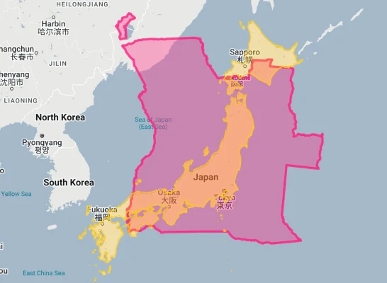
- Angola vs. Japan: Angola is approximately 3.3 times larger than Japan, despite Japan having about five times more people.
- Angola vs. India:

- Angola vs. Australia:

Angola’s Geographic Diversity: From Desert to Rainforest
Angola’s territory encompasses remarkable environmental diversity:
- Coastal Lowlands: A narrow strip of land along the Atlantic coast, varying from 50-200 kilometers (31-124 miles) in width, which includes the capital Luanda and the exclave of Cabinda
- Marginal Mountains: Rising abruptly from the coastal plain, these mountains form an escarpment reaching heights of 1,000-2,000 meters (3,280-6,560 feet)
- Central Plateau: The vast majority of Angola consists of a high plateau ranging from 1,000-1,800 meters (3,280-5,900 feet) in elevation
- Eastern Plains: The plateau gradually descends towards the eastern border with Zambia, forming part of the vast Central African plateau
- Namib Desert: The southwestern corner of Angola contains a portion of the Namib Desert, one of the oldest and driest deserts in the world
- Atlantic Coastline: Angola possesses 1,600 kilometers (994 miles) of Atlantic coastline, providing strategic maritime access
The Cabinda Exclave: Angola’s Oil-Rich Appendage
The Cabinda exclave represents a unique geographical feature of Angola:
- Cabinda is a small territory of 7,270 square kilometers (2,807 square miles)—about the size of Delaware—separated from mainland Angola by a narrow strip of Democratic Republic of Congo territory
- Despite its small size, Cabinda produces approximately 60% of Angola’s oil, making it economically crucial to the country
- The exclave is surrounded by the Republic of Congo to the north, the Democratic Republic of Congo to the east and south, and the Atlantic Ocean to the west
- Unlike mainland Angola’s predominantly savanna and plateau environments, Cabinda features dense tropical rainforest
- The region has a distinct cultural identity and has experienced separatist movements seeking independence, although it remains firmly under Angolan control
Angola’s Vital River Systems
Angola’s extensive river network is crucial to its geography and development:
- The country contains portions of four major African river basins: the Congo, Zambezi, Okavango, and Cunene
- The Cuanza (Kwanza) River, Angola’s longest river entirely within its borders at 960 kilometers (596 miles), flows into the Atlantic near Luanda and gives its name to the national currency
- The Okavango River originates in Angola’s central highlands before flowing southeast into Botswana, where it forms the famous Okavango Delta, one of Africa’s most important wetland ecosystems
- The Cunene River forms part of Angola’s southern border with Namibia and is harnessed for hydroelectric power at the Ruacana Falls
- Angola’s rivers represent enormous hydroelectric potential, with numerous dams already built and more planned as the country develops its infrastructure
Population Distribution: A Coastal Concentration
Angola’s population pattern shows interesting demographic trends:
- With approximately 34 million people, Angola has a relatively low average population density of about 27 people per square kilometer
- This density varies dramatically by region, with Luanda Province having over 347 people per square kilometer while some interior provinces have fewer than 10 people per square kilometer
- About 65% of Angolans live in urban areas, one of the highest urbanization rates in Africa
- Luanda, the capital and largest city with about 8.6 million inhabitants, contains approximately 25% of the country’s entire population
- The population distribution was significantly affected by the civil war (1975-2002), which drove many rural residents to cities and coastal areas for safety
Angola’s Provinces: Large as European Nations
Many of Angola’s 18 provinces (administrative divisions) are comparable in size to entire countries:
| Angolan Province | Area (km²) | Comparable Country |
|---|---|---|
| Cuando Cubango | 199,049 | Kyrgyzstan (199,951 km²) |
| Moxico | 223,023 | Romania (238,397 km²) |
| Cunene | 89,342 | Portugal (92,212 km²) |
| Lunda Norte | 103,760 | Iceland (103,000 km²) |
| Malanje | 97,602 | Hungary (93,028 km²) |
Geography and Climate: A Country of Contrasts
Angola’s diverse geography creates a complex climatic mosaic:
- The country experiences three distinct climate zones: a cool, dry coastal zone influenced by the cold Benguela Current; a temperate highland zone with alternating rainy and dry seasons; and a hot, humid northern zone with a longer rainy season
- Annual rainfall varies dramatically from less than 50 mm (2 inches) in parts of the southwest desert to over 1,500 mm (59 inches) in the northern rainforests
- The rainy season generally occurs from September/October to April/May, though timing varies by region
- Temperature ranges are moderated by elevation across much of the country, with the central plateau experiencing comfortable temperatures year-round despite the tropical latitude
- The influence of the cold Benguela Current creates unusually cool, dry conditions along the coast, including morning fog in the southwestern littoral
Natural Resources: Diamonds, Oil, and Agricultural Potential
Angola’s vast territory contains extraordinary resource wealth:
- Angola is Africa’s second-largest oil producer after Nigeria, with major offshore fields along its coast and in the Cabinda exclave
- The country is the world’s fifth-largest producer of diamonds by value, with significant deposits in the northeastern provinces of Lunda Norte and Lunda Sul
- Angola possesses substantial reserves of iron ore, copper, gold, phosphates, uranium, feldspar, and other minerals
- The central highlands offer excellent agricultural potential, with fertile soils suitable for coffee, cotton, sugarcane, bananas, and other crops
- Angola’s extensive coastline provides access to rich fishing grounds, though this potential remains underdeveloped
The Central Highlands: Angola’s Agricultural Heartland
Angola’s central highlands represent the country’s most productive agricultural region:
- The highlands, known as the planalto, average about 1,500 meters (4,920 feet) in elevation and cover much of central Angola
- This region enjoys a temperate climate with reliable rainfall between 1,000-1,500 mm (39-59 inches) annually
- Before Angola’s civil war, the central highlands were the center of a thriving coffee industry that made Angola the world’s fourth-largest coffee producer
- The area remains the country’s primary food-producing region, growing maize, beans, potatoes, and other staple crops
- Major cities in the highlands include Huambo and Lubango, important agricultural and commercial centers
Geographic Challenges: Reconstruction and Development
Angola’s geography creates both opportunities and challenges for development:
- Infrastructure Damage: Angola’s 27-year civil war (1975-2002) devastated much of the country’s infrastructure, including roads, bridges, and irrigation systems
- Land Mines: Angola remains one of the world’s most heavily mined countries, with an estimated 1,100 minefields still requiring clearance, restricting access to agricultural land and impeding development
- Regional Disparities: The concentration of development along the coast, particularly around Luanda, has created major regional inequalities
- Water Management: Despite abundant water resources, Angola faces challenges in water management, with periodic droughts in the south and flooding in other regions
- Deforestation: Angola’s forests, particularly in Cabinda and the northern provinces, face pressure from commercial logging, charcoal production, and agricultural expansion
The Colonial Footprint: Portugal’s African Giant
Angola’s current geography bears significant imprints from its colonial past:
- Angola was Portugal’s largest colonial territory, with Portuguese presence dating from the late 15th century until independence in 1975
- The colonial administration established a transportation network focused on extracting resources from the interior to coastal ports rather than connecting different regions of the country
- Portuguese is Angola’s official language and serves as a unifying factor in a country with numerous ethnic groups and indigenous languages
- Colonial-era agriculture focused on export crops like coffee, introducing non-native species and plantation systems that transformed parts of the landscape
- Many Angolan cities, including Luanda, retain Portuguese architectural influences, with colonial-era buildings forming important parts of the urban landscape
Explore More Size Comparisons
Curious about how other major countries and continents compare in true size? Check out these related articles:
- The Enormous Truth About Niger: Africa’s Desert Giant That Could Swallow Europe Whole
- The Real Size of Mali: The African Giant as Big as All of Western Europe
- The Colossal Truth About Chad: Africa’s Hidden Giant Bigger Than All of Western Europe
- The True Size of Africa: A Continent Far Larger Than Maps Suggest
- Complete List of Countries by True Size
Sources & Further Reading
- Instituto Nacional de Estatística de Angola. (2023). Geographical and Statistical Data.
- CIA World Factbook. (2023). Angola.