Colombia
World Rank: #22
1,141,748 km²



Colombia: The Colossal Andean Nation Most People Underestimate
Colombia ranks as the twenty-second largest country in the world with a territory of 1,141,748 square kilometers (440,831 square miles). This vast South American nation is the continent’s fourth-largest country, yet its true scale remains consistently underappreciated by global audiences. What’s truly astonishing is that Colombia’s massive expanse could contain France, Germany, and Italy combined—essentially encompassing three of Europe’s largest and most powerful nations with room to spare.
What makes Colombia’s geography extraordinary is its remarkable diversity, featuring three branches of the Andes mountains, vast Caribbean and Pacific coastlines, extensive Amazon rainforest, fertile river valleys, and tropical plains. This geographic mosaic has created one of the world’s most biodiverse countries, ranking second globally in biodiversity despite occupying less than 1% of Earth’s land surface.
Located between approximately 4° South and 12° North latitude, Colombia straddles the equator, experiencing minimal distortion on standard Mercator projection maps. However, its geographic complexity and the psychological tendency to underestimate South American countries’ dimensions have contributed to widespread misconceptions about Colombia’s true size.
Watch Colombia shrink to its actual size as we move it toward the equator. We compare it to the USA, Europe, Africa, Greenland, Brazil, Australia, Russia, India, China, etc. You can use this country size comparison interactive map here.
Colombia’s True Size Will Astound You: Global Perspective
To truly grasp Colombia’s dimensions, these direct comparisons with familiar countries and regions provide eye-opening context:

Colombia vs. Western Europe: Colombia would completely engulf several major European powers combined
| Comparison | Area (km²) | Size Relative to Colombia |
|---|---|---|
| Colombia | 1,141,748 | 1.0 |
| France, Germany, and Italy combined | ~1,024,000 | ~0.90 times Colombia’s size |
| Ethiopia | 1,104,300 | 0.97 times Colombia’s size |
| Texas and New Mexico combined (US states) | ~1,032,000 | ~0.90 times Colombia’s size |
| Egypt | 1,001,450 | 0.88 times Colombia’s size |
5 Mind-Blowing Colombia Size Comparisons You Never Imagined
- Colombia vs. United States: Colombia is larger than Texas and New Mexico combined. If placed over the eastern United States, it would stretch from New York to Georgia and west to Illinois.

- Colombia vs. Western Europe: Colombia could contain France, Germany, Italy, and Belgium combined.
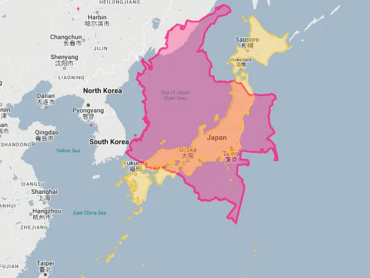
- Colombia vs. Japan:
- Colombia vs. India:
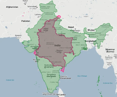
- Colombia vs. Australia:

Colombia’s Geographic Diversity: Five Natural Regions
Colombia’s territory divides into five distinct natural regions, each with its own character:
- Andean Region: Colombia contains three distinct cordilleras (mountain ranges) of the Andes that run roughly north-south through the country, creating dramatically different ecosystems and climates
- Caribbean Region: The northern coastline along the Caribbean Sea features beaches, desert areas, and the isolated Sierra Nevada de Santa Marta mountain range
- Pacific Region: The western coastline along the Pacific Ocean is one of the wettest areas on Earth, covered with dense rainforest
- Orinoquía Region: The vast tropical grassland plains (llanos) in the east form part of the Orinoco River basin
- Amazon Region: The southeastern portion of Colombia contains part of the Amazon rainforest, representing about a third of the country’s total area
The Three Cordilleras: Colombia’s Mountainous Backbone
The Andes mountains split into three distinct ranges within Colombia, creating a defining feature of the country’s geography:
- The Cordillera Occidental (Western Range) runs parallel to the Pacific coast and reaches heights of up to 4,764 meters (15,630 feet) at Farallones de Cali
- The Cordillera Central (Central Range) contains several active volcanoes and Colombia’s highest peak in the volcanic Nevado del Huila at 5,364 meters (17,598 feet)
- The Cordillera Oriental (Eastern Range) is the widest of the three ranges and extends into Venezuela
- Between these mountain ranges lie two major river valleys: the Magdalena River valley between the Central and Eastern ranges, and the Cauca River valley between the Western and Central ranges
- This complex topography creates an extraordinary variety of ecosystems within short distances, from tropical rainforests to high-altitude páramo grasslands
The Sierra Nevada de Santa Marta: An Isolated Wonder
The Sierra Nevada de Santa Marta represents one of the world’s most remarkable geographical features:
- This isolated mountain range rises directly from the Caribbean coast to 5,775 meters (18,947 feet) at its highest peaks, Pico Cristóbal Colón and Pico Simón Bolívar
- It is the world’s highest coastal mountain range and contains the highest point in Colombia
- Despite being only about 42 kilometers (26 miles) from the Caribbean Sea, its peaks are permanently snow-capped
- The Sierra Nevada is geologically unrelated to the Andes, forming its own distinct mountain system
- This isolated “island mountain” contains an extraordinary range of ecosystems, from tropical rainforest at its base to glaciers at its summit, and is home to numerous endemic species
Colombia’s Dual Coastlines: Caribbean and Pacific
Colombia is one of the few South American countries with coastlines on both the Caribbean Sea and the Pacific Ocean:
- The Colombian Caribbean coastline extends for 1,760 kilometers (1,094 miles) and includes tourist destinations like Cartagena, Santa Marta, and the Rosario Islands
- The Pacific coastline runs for 1,300 kilometers (808 miles) and is predominantly covered by dense rainforest with few large settlements
- The two coasts have dramatically different characteristics—the Caribbean coast has clearer, calmer waters with white sand beaches, while the Pacific coast features darker sand, rougher seas, and is one of the rainiest regions on Earth
- This dual maritime access has given Colombia significant strategic importance throughout its history
- Colombia also claims a small island territory in the Caribbean far from its mainland—the archipelago of San Andrés, Providencia, and Santa Catalina, located closer to Nicaragua than to continental Colombia
Population Distribution: Andean Concentration
Colombia’s population pattern shows a strong geographic concentration:
- With approximately 51 million people, Colombia has a moderate average population density of about 45 people per square kilometer
- This density varies dramatically by region, with about 75% of Colombians living in the Andean region, which comprises only about 25% of the country’s territory
- The eastern plains (Orinoquía) and Amazon regions, which make up more than half of Colombia’s territory, contain less than 5% of the population
- About 80% of Colombians live in urban areas, with major cities concentrated in the Andean highlands and along the Caribbean coast
- Bogotá, the capital and largest city with about 7.4 million inhabitants within city limits (and over 10 million in the metropolitan area), sits high in the Andes at 2,640 meters (8,660 feet) above sea level
Colombia’s Departments: Large as European Nations
Many of Colombia’s 32 departments (administrative divisions) are comparable in size to entire countries:
| Colombian Department | Area (km²) | Comparable Country |
|---|---|---|
| Amazonas | 109,665 | Bulgaria (110,994 km²) |
| Caquetá | 88,965 | Austria (83,871 km²) |
| Meta | 85,635 | Portugal (92,212 km²) |
| Vichada | 100,242 | South Korea (100,210 km²) |
| Antioquia | 63,612 | Lithuania (65,300 km²) |
Geography and Climate: “The Land of Every Climate”
Colombia’s complex topography creates an extraordinary variety of climate zones:
- Colombia is sometimes called “the land of every climate” (la tierra de todos los climas) due to its remarkable climate diversity
- Despite being in the tropics, Colombia’s climate is determined more by altitude than by season, creating what Colombians call “thermal floors” (pisos térmicos)
- At sea level, temperatures average around 30°C (86°F) year-round, while at Bogotá’s elevation, temperatures average about 14°C (57°F)
- The combination of tropical location and varying altitude creates distinct climate zones, from hot lowlands (tierra caliente) below 1,000 meters, to temperate zones (tierra templada) between 1,000-2,000 meters, cool highlands (tierra fría) between 2,000-3,000 meters, and páramo regions above 3,000 meters
- Colombia’s climate pattern typically includes two dry and two wet seasons each year, though this varies significantly by region
Biodiversity Superpower: Second Only to Brazil
Colombia’s diverse geography has created extraordinary biological richness:
- Colombia is the second most biodiverse country in the world (after Brazil), containing about 10% of the world’s biodiversity in less than 1% of the Earth’s land area
- The country ranks first globally in bird and orchid species diversity, second in plants, amphibians, butterflies, and freshwater fish, and third in reptiles and palms
- Colombia contains an estimated 51,330 species, many of which are endemic (found nowhere else)
- This extraordinary biodiversity results from Colombia’s complex topography, location between two oceans, and position at the junction of North and South America
- Major biodiversity hotspots include the Chocó rainforest along the Pacific coast (one of the wettest and most biodiverse regions on Earth), the Amazon rainforest, the Andean cloud forests, and the Sierra Nevada de Santa Marta
The Magdalena River: Colombia’s Mississippi
The Magdalena River forms the dominant waterway and historical lifeline of Colombia:
- Stretching 1,528 kilometers (949 miles), the Magdalena is Colombia’s principal river, flowing northward between the Central and Eastern Cordilleras to the Caribbean Sea
- The river drains about 24% of Colombia’s territory through its basin, which is home to approximately 80% of the country’s population
- Historically, the Magdalena was Colombia’s main transportation route, connecting the interior highlands with the Caribbean coast
- The river passes through a remarkable variety of ecosystems, from Andean highlands to tropical lowlands
- Despite its importance, the Magdalena faces significant environmental challenges, including pollution, deforestation in its watershed, and infrastructure development
Geographic Challenges: Mountains and Connectivity
Colombia’s complex geography creates significant development challenges:
- Transportation: The three Andean cordilleras have historically made transportation and national integration difficult, with many regions remaining relatively isolated
- Regional Development: The concentration of population and infrastructure in the Andean region has contributed to uneven development, with remote areas in the Amazon and Pacific coast lagging behind
- Natural Disasters: Colombia’s location along the Pacific Ring of Fire and in a zone of high tectonic activity makes it vulnerable to earthquakes, volcanic eruptions, and landslides
- Climate Change: The country is particularly vulnerable to climate change impacts, with Andean glaciers retreating rapidly and increased risks of floods and droughts
- Deforestation: Despite conservation efforts, Colombia continues to lose forest cover, particularly in the Amazon region
Natural Resources: From Emeralds to Oil
Colombia’s diverse territory contains extraordinary resource wealth:
- Colombia produces about 90% of the world’s finest emeralds, particularly from mines in the departments of Boyacá and Cundinamarca
- The country has significant reserves of oil, natural gas, and coal, with petroleum production centered in the eastern plains and coal mining in the north
- Colombia is a major producer of gold, nickel, copper, and other minerals
- The country’s varied climate zones allow for the cultivation of diverse agricultural products, from coffee in the temperate highlands to tropical fruits in the lowlands
- Colombia’s extensive river systems create substantial hydroelectric potential, which provides the majority of the country’s electricity
Explore More Size Comparisons
Curious about how other major countries and continents compare in true size? Check out these related articles:
- The Shocking Truth About South Africa’s Size: Rainbow Nation Larger Than Every Country in Western Europe Combined
- The Unexpected Scale of Ethiopia: Ancient Kingdom as Massive as France and Spain Together
- The Hidden Vastness of Mali: Africa’s Desert Empire Larger Than All of France, Spain and Germany Combined
- Complete List of Countries by True Size
Sources & Further Reading
- Departamento Administrativo Nacional de Estadística (DANE). (2023). Geographical and Statistical Data.
- Instituto Geográfico Agustín Codazzi. (2022). Geographic Information.
- CIA World Factbook. (2023). Colombia.