South Africa
World Rank: #21
1,219,090 km²
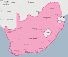




South Africa: The Continental Powerhouse Far Larger Than Maps Suggest
South Africa ranks as the twenty-first largest country in the world with a territory of 1,219,090 square kilometers (470,693 square miles). This substantial Southern African nation is the continent’s ninth-largest country, yet its true scale remains consistently underappreciated by global audiences. What’s genuinely astonishing is that South Africa’s massive expanse could contain France, Germany, Italy, the United Kingdom, and the Netherlands combined—essentially swallowing most of Western Europe with room to spare.
What makes South Africa’s geography extraordinary is its remarkable diversity, spanning everything from arid desert to subtropical forests, high mountains to coastal plains, and savannas to Mediterranean scrubland. This environmental mosaic has created one of the world’s most biodiverse countries, despite occupying less than 1% of Earth’s land surface. South Africa is also the only country globally to contain an entire floral kingdom within its borders (the Cape Floral Kingdom).
Located between approximately 22° and 35° South latitude, South Africa experiences moderate distortion on standard Mercator projection maps. Its territory appears somewhat smaller than it truly is, particularly in relation to European countries that are shown larger than their actual size on such projections. This cartographic distortion has contributed to the widespread underestimation of South Africa’s true dimensions.
Watch South Africa shrink to its actual size as we move it toward the equator. We compare it to the USA, Europe, Africa, Greenland, Brazil, Australia, Russia, India, China, etc. You can use this country size comparison interactive map here.
South Africa’s Massive True Size Will Astonish You: Global Perspective
To truly grasp South Africa’s dimensions, these direct comparisons with familiar countries and regions provide eye-opening context:

South Africa vs. Western Europe: South Africa would engulf several major European powers combined
| Comparison | Area (km²) | Size Relative to South Africa |
|---|---|---|
| South Africa | 1,219,090 | 1.0 |
| France, Germany, Italy, UK, and Netherlands combined | ~1,126,300 | ~0.92 times South Africa’s size |
| Colombia | 1,141,748 | 0.94 times South Africa’s size |
| Texas and Oklahoma combined (US states) | ~1,021,000 | ~0.84 times South Africa’s size |
| Egypt | 1,001,450 | 0.82 times South Africa’s size |
5 Jaw-Dropping South Africa Size Comparisons You Won’t Believe
- South Africa vs. United States: South Africa is roughly twice the size of Texas, America’s second-largest state. If placed over the eastern United States, it would stretch from New York to South Carolina and west to Ohio.

- South Africa vs. Western Europe: South Africa could contain France, Germany, Italy, the United Kingdom, and the Netherlands simultaneously.
- South Africa vs. Japan: South Africa is approximately 3.2 times larger than Japan, despite Japan having more than twice South Africa’s population.

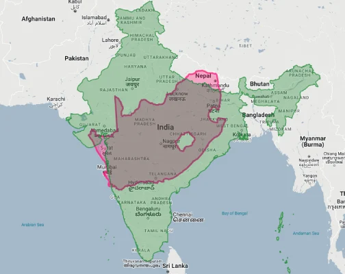
- South Africa vs. India:
- South Africa vs. Australia:

South Africa’s Geographic Diversity: A World in One Country
South Africa’s terrain encompasses an astonishing variety of landscapes:
- Great Escarpment: A dramatic mountain range running parallel to the coast and separating the coastal lowlands from the interior plateau
- Interior Plateau: The vast Highveld and Karoo regions comprising most of the country’s interior at elevations of 1,000-2,000 meters (3,300-6,600 feet)
- Coastal Plains: Narrow lowland regions between the Great Escarpment and the ocean, varying in width and character along the country’s 2,798 kilometers (1,739 miles) of coastline
- Kalahari Desert: The southwestern portion of South Africa contains part of this extensive desert system
- Bushveld: The northern lowveld region features typical African savanna ecosystems
- Cape Region: The southwestern tip features Mediterranean climate and the unique fynbos vegetation of the Cape Floral Kingdom
The Great Escarpment: South Africa’s Dramatic Backbone
The Great Escarpment forms the defining geographic feature of South Africa:
- This dramatic mountain range encircles the interior plateau of Southern Africa, with its most spectacular portion in South Africa
- The Drakensberg section of the escarpment reaches 3,482 meters (11,424 feet) at Thabana Ntlenyana, the highest point in Southern Africa (located just across the border in Lesotho)
- The escarpment forms a natural barrier between the coastal plains and the interior plateau, historically making travel between these regions difficult
- This geographic feature profoundly influences South Africa’s climate, creating distinct rainfall patterns between the wetter coastal regions and drier interior
- The spectacular Drakensberg contains some of the world’s oldest rock art, created by the indigenous San people over thousands of years
The Cape Floral Kingdom: A Biological Marvel
South Africa contains the smallest and richest of Earth’s six floral kingdoms:
- The Cape Floral Kingdom (or Cape Floristic Region) occupies just 90,000 square kilometers (34,750 square miles)—less than 0.5% of Africa’s area—yet contains about 9,000 plant species, 70% of which are found nowhere else on Earth
- This region has the highest known concentration of plant species in the world—158 species per 1,000 square kilometers
- The iconic fynbos (“fine bush”) vegetation dominates this floral kingdom, characterized by proteas, ericas, and restios
- South Africa is the only country in the world to contain an entire floral kingdom within its borders
- This extraordinary biodiversity has earned the region UNESCO World Heritage status and contributed to South Africa’s reputation as one of the world’s “megadiverse” countries
Population Distribution: Coastal and Metropolitan Concentration
South Africa’s population pattern shows interesting demographic trends:
- With approximately 60 million people, South Africa has a moderate average population density of about 49 people per square kilometer
- This density varies dramatically by region, with Gauteng Province (containing Johannesburg) having over 700 people per square kilometer while the Northern Cape has fewer than 4 people per square kilometer
- About 67% of South Africans live in urban areas, with the major metropolitan centers concentrated in the eastern half of the country and along the coast
- Three distinct metropolitan clusters have emerged: the Gauteng urban region (including Johannesburg and Pretoria), the Durban-Pietermaritzburg corridor in KwaZulu-Natal, and the Cape Town metropolitan area
- Historical factors, including both precolonial settlement patterns and colonial/apartheid policies, have significantly influenced the current population distribution
South Africa’s Provinces: Large as European Nations
Many of South Africa’s 9 provinces (administrative divisions) are comparable in size to entire countries:
| South African Province | Area (km²) | Comparable Country |
|---|---|---|
| Northern Cape | 372,889 | Japan (377,975 km²) |
| Eastern Cape | 168,966 | Syrian Arab Republic (185,180 km²) |
| Free State | 129,825 | Greece (131,957 km²) |
| Western Cape | 129,462 | Nicaragua (130,373 km²) |
| Limpopo | 125,754 | North Korea (120,538 km²) |
Geography and Climate: Extraordinary Diversity
South Africa’s diverse geography creates an unusually varied climate:
- The country experiences at least six distinct climate zones, from Mediterranean in the southwest to subtropical in the northeast, and from desert in the northwest to temperate highlands in the interior
- Annual rainfall varies dramatically from less than 200 mm (8 inches) in parts of the Northern Cape to over 1,200 mm (47 inches) in parts of KwaZulu-Natal
- Most of the country experiences summer rainfall (October to March), while the Western Cape has a Mediterranean climate with winter rainfall (May to August)
- The influence of ocean currents is significant—the cold Benguela Current along the west coast creates cool, dry conditions, while the warm Agulhas Current along the east coast brings humid, subtropical weather
- Elevation plays a major role in temperature variations, with the high interior plateau experiencing much cooler temperatures than coastal areas at the same latitude
The “Hole in the Map”: Lesotho’s Unique Position
South Africa completely surrounds the mountain kingdom of Lesotho:
- Lesotho (30,355 square kilometers/11,720 square miles) is one of only three countries in the world completely surrounded by a single country (the others being San Marino and Vatican City, both surrounded by Italy)
- Known as the “Kingdom in the Sky,” Lesotho is the only country in the world with all its territory above 1,000 meters (3,280 feet) in elevation
- This geographic arrangement creates the distinctive “hole” in South Africa’s map that makes the country instantly recognizable
- The Lesotho highlands contain the headwaters of the Orange River, South Africa’s longest river
- The Lesotho Highlands Water Project, a massive engineering scheme, transfers water from the mountains of Lesotho to South Africa’s industrial heartland in Gauteng
Natural Resources: Mineral Wealth and Beyond
South Africa’s territory contains extraordinary resource wealth:
- The country possesses the world’s largest reserves of platinum group metals, manganese, and chromium
- South Africa has produced about 40% of all gold ever mined in human history
- The Bushveld Igneous Complex in the northeast is the world’s richest mineral deposit, containing vast reserves of platinum, chromium, vanadium, and other metals
- South Africa is home to some of the world’s largest diamond mines, though diamond production has declined from its historical peak
- Beyond minerals, the country possesses rich agricultural land, extensive fisheries along its coasts, and significant potential for renewable energy, particularly solar and wind power
The Great Karoo: Africa’s Vast Interior Basin
The Karoo forms a distinctive region covering much of South Africa’s interior:
- This vast semi-arid plateau covers approximately 400,000 square kilometers (154,440 square miles)—roughly one-third of South Africa’s total area
- The region is divided into the Great Karoo in the north and the Little Karoo in the south, separated by the Swartberg mountain range
- Despite its arid appearance, the Karoo supports a surprising diversity of plant and animal life adapted to its harsh conditions
- The region contains some of the world’s most important paleontological sites, particularly for fossils from the Permian era (299-252 million years ago)
- The Karoo’s clear skies and minimal light pollution have made it home to the Southern African Large Telescope (SALT), the largest optical telescope in the Southern Hemisphere
Geographic Challenges: Water Scarcity and Climate Change
South Africa’s geography creates significant challenges:
- Water Scarcity: South Africa is classified as a water-scarce country, with average annual rainfall of 464 mm (18.3 inches), well below the global average of 860 mm (33.9 inches)
- Climate Change: The country is particularly vulnerable to climate change, with projections showing increased temperatures, more variable rainfall, and more frequent extreme weather events
- Biodiversity Threats: Habitat loss, invasive species, and climate change threaten South Africa’s extraordinary biodiversity
- Coastal Vulnerability: With nearly 3,000 kilometers (1,864 miles) of coastline, South Africa faces significant challenges from sea level rise and coastal erosion
- Spatial Inequality: The historical development of South Africa has created stark spatial inequalities, with infrastructure and services unevenly distributed across the country
The Republic’s Borders: Rivers and Mountain Ranges
South Africa’s boundaries reflect both natural features and colonial history:
- The Orange River forms much of the northwestern border with Namibia
- The Limpopo River defines the northern border with Zimbabwe and part of the border with Botswana
- The Drakensberg mountain range forms much of the border with Lesotho and parts of the border with Mozambique and Zimbabwe
- South Africa shares borders with six countries: Namibia, Botswana, Zimbabwe, Mozambique, Eswatini (formerly Swaziland), and Lesotho (which it completely surrounds)
- Many of these borders reflect colonial-era demarcations rather than natural dividing lines between indigenous territories
Explore More Size Comparisons
Curious about how other major countries and continents compare in true size? Check out these related articles:
- The Hidden Vastness of Mali: Africa’s Desert Empire Larger Than All of France, Spain and Germany Combined
- The Real Size of Colombia: The Andean Giant Larger Than Spain, France and Portugal Combined
- The Astonishing Scale of Angola: Africa’s Atlantic Giant Larger Than Five United Kingdoms
- The True Size of Africa: A Continent Far Larger Than Maps Suggest
- Complete List of Countries by True Size
Sources & Further Reading
- Statistics South Africa. (2023). Geographical and Statistical Data.
- South African National Biodiversity Institute. (2022). Biodiversity Information.
- CIA World Factbook. (2023). South Africa.