Ethiopia
World Rank: #23
1,104,300 km²
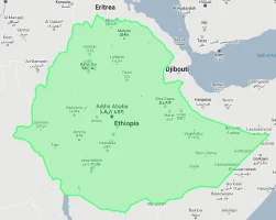



Ethiopia: The Vast Ancient Kingdom That Towers Over Europe
Ethiopia ranks as the twenty-third largest country in the world with a territory of 1,104,300 square kilometers (426,371 square miles). This immense East African nation is the continent’s tenth-largest country, yet its true scale remains consistently underappreciated in global consciousness. What’s truly astonishing is that Ethiopia’s massive expanse could contain France and Spain combined—essentially swallowing two of Europe’s largest nations with room to spare for Portugal.
What makes Ethiopia’s geography extraordinary is its remarkable highland character, centered on the Ethiopian Plateau that rises dramatically above the surrounding lowlands. Often called the “Roof of Africa,” Ethiopia contains some of the continent’s highest peaks and most spectacular mountain scenery. Unlike many African nations, Ethiopia’s high elevation creates a temperate climate despite its tropical latitude, contributing to its unique cultural and agricultural development.
Located between approximately 3° and 15° North latitude, Ethiopia experiences relatively little distortion on standard Mercator projection maps. However, global perceptions of African geography, combined with Ethiopia’s complex topography and landlocked status, have contributed to widespread underestimation of its true dimensions and geographic significance.
Watch Ethiopia shrink to its actual size as we move it toward the equator. We compare it to the USA, Europe, Africa, Greenland, Brazil, Australia, Russia, India, China, etc. You can use this country size comparison interactive map here.
Ethiopia’s True Size Will Shock You: Global Perspective
To truly grasp Ethiopia’s dimensions, these direct comparisons with familiar countries and regions provide eye-opening context:
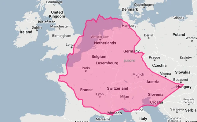
Ethiopia vs. Western Europe: Ethiopia would completely engulf several major European powers combined
| Comparison | Area (km²) | Size Relative to Ethiopia |
|---|---|---|
| Ethiopia | 1,104,300 | 1.0 |
| France and Spain combined | ~1,049,000 | ~0.95 times Ethiopia’s size |
| Egypt | 1,001,450 | 0.91 times Ethiopia’s size |
| Texas and Oklahoma combined (US states) | ~1,021,000 | ~0.92 times Ethiopia’s size |
| United Kingdom, Italy, Germany, and Belgium combined | ~947,000 | ~0.86 times Ethiopia’s size |
5 Astonishing Ethiopia Size Comparisons You’ve Never Seen
- Ethiopia vs. United States: Ethiopia is larger than Texas and New Mexico combined. If placed over the eastern United States, it would stretch from Pennsylvania to South Carolina and west to Indiana.

- Ethiopia vs. Western Europe: Ethiopia could contain France, Spain, and Portugal combined.
- Ethiopia vs. Japan: Ethiopia is approximately 2.9 times larger than Japan, despite Japan having about 2.5 times Ethiopia’s population.
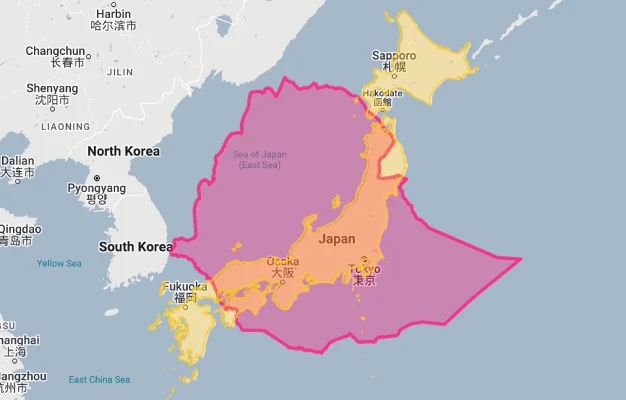
- Ethiopia vs. India:
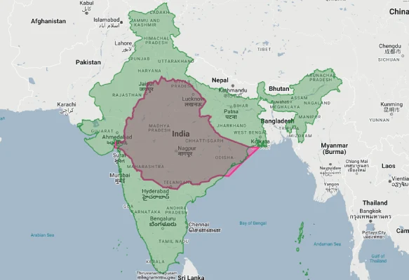
- Ethiopia vs. Australia:

Ethiopia’s Geographic Diversity: From Alpine Heights to Desert Depths
Ethiopia’s territory encompasses a remarkable diversity of landscapes:
- Ethiopian Highlands: The vast central plateau that dominates the country, divided by the Great Rift Valley into northwestern and southeastern sections
- Great Rift Valley: Part of the 6,000-kilometer (3,700-mile) geological fracture that bisects Eastern Africa runs through Ethiopia, creating a dramatic landscape of lakes, volcanoes, and escarpments
- Danakil Depression: One of the lowest and hottest places on Earth, located in northeastern Ethiopia near the Red Sea
- Western Lowlands: Hot, humid areas along the border with Sudan that gradually descend from the highlands
- Southeastern Lowlands: Semi-arid to arid plains extending toward Somalia and Kenya
The Ethiopian Highlands: Roof of Africa
The Ethiopian Highlands form the country’s defining geographical feature:
- This massive highland complex covers approximately two-thirds of Ethiopia’s territory, with elevations typically ranging from 1,500 to 3,000 meters (4,900 to 9,800 feet)
- Ras Dashen in the Simien Mountains, at 4,550 meters (14,928 feet), is Ethiopia’s highest point and the fourth-highest peak in Africa
- The highlands’ cool temperatures and reliable rainfall have made them the historical center of Ethiopian civilization, with most of the country’s population still concentrated in these regions
- This massive plateau is the largest continuous area of its elevation in Africa, with an average elevation similar to areas of the Rocky Mountains in the United States
- The highlands contain the headwaters of major rivers including the Blue Nile (Abay), which provides approximately 85% of the water that reaches Egypt via the main Nile
The Great Rift Valley: Splitting the Continent
The Great Rift Valley forms a spectacular geological feature through Ethiopia:
- This massive geological fault system cuts diagonally through Ethiopia from the northeast to the southwest, creating a dramatic valley flanked by high escarpments
- The Ethiopian section contains a string of lakes, including Lake Tana (source of the Blue Nile) and a series of alkaline lakes in the southern regions
- The Rift Valley in Ethiopia includes active volcanoes such as Erta Ale, featuring one of the world’s few permanent lava lakes
- This geological feature effectively splits the Ethiopian Highlands into northwestern and southeastern sections
- The Ethiopian Rift Valley has yielded some of the most important paleontological and archaeological discoveries in human history, including “Lucy” (Australopithecus afarensis), one of the oldest and most complete hominin fossils ever found
The Danakil Depression: Earth’s Alien Landscape
The Danakil Depression in northeastern Ethiopia represents one of the world’s most extreme environments:
- Located in the Afar Region near the border with Eritrea, this geological depression reaches 125 meters (410 feet) below sea level, making it one of the lowest land points on Earth
- It is one of the hottest places on the planet, with average daily temperatures regularly exceeding 45°C (113°F) and sometimes reaching 50°C (122°F)
- The region features surreal, otherworldly landscapes, including salt flats, sulfur springs, and multicolored hydrothermal fields that often appear more like an alien planet than Earth
- Dallol, a cinder cone volcano in the depression, features acid pools, salt formations, and mineral springs that create vivid yellow, orange, and green deposits
- Despite its inhospitable conditions, the Afar people have developed techniques to mine salt from the region, continuing a trade that has existed for at least 2,000 years
Population Distribution: Highland Concentration
Ethiopia’s population pattern reflects its highland geography:
- With approximately 120 million people, Ethiopia is Africa’s second-most populous country after Nigeria
- Population density varies dramatically, with about 80% of Ethiopians living in the highlands, which constitute roughly 60% of the country’s territory
- The hot, arid lowlands of the Danakil Depression and the southeastern border regions are very sparsely populated
- Unlike many African countries, Ethiopia remains predominantly rural, with only about 22% of the population living in urban areas
- Addis Ababa, the capital and largest city with about 5 million inhabitants, sits in the central highlands at an elevation of approximately 2,355 meters (7,726 feet), making it one of the highest capital cities in the world
Ethiopia’s Regions: Large as European Nations
Many of Ethiopia’s 11 regions (administrative divisions) are comparable in size to entire countries:
| Ethiopian Region | Area (km²) | Comparable Country |
|---|---|---|
| Oromia | 353,690 | Germany (357,022 km²) |
| Somali | 279,252 | Ecuador (276,841 km²) |
| Amhara | 154,709 | Bangladesh (147,570 km²) |
| Afar | 96,707 | South Korea (100,210 km²) |
| Tigray | 53,638 | Croatia (56,594 km²) |
Geography and Climate: Elevation Over Latitude
Ethiopia’s complex topography creates a remarkable variety of climatic zones:
- Despite being located entirely within the tropics, Ethiopia’s climate is largely determined by elevation rather than latitude
- Ethiopians traditionally recognize three distinct climate zones based on elevation: kolla (hot lowlands below 1,800 meters), weyna dega (temperate midlands from 1,800-2,400 meters), and dega (cool highlands above 2,400 meters)
- Average temperatures in the highlands typically range from 16-20°C (61-68°F), while lowland areas regularly exceed 35°C (95°F)
- Rainfall patterns vary significantly, with the southwestern highlands receiving over 2,000 mm (79 inches) annually, while parts of the northeast and southeast receive less than 200 mm (7.9 inches)
- Ethiopia typically experiences two rainy seasons: the small rains (belg) from February to April and the main rains (kiremt) from June to September, though patterns vary by region
The Blue Nile: Ethiopia’s Gift to Egypt
The Blue Nile represents one of Ethiopia’s most significant geographical features:
- The Blue Nile (locally known as Abay) originates at Lake Tana in the northwestern highlands and travels approximately 1,450 kilometers (900 miles) within Ethiopia before crossing into Sudan
- This river provides approximately 85% of the water that reaches Egypt via the main Nile River
- The Blue Nile Falls (Tis Abay or “smoking water” in Amharic), located near the river’s source at Lake Tana, drops approximately 45 meters (148 feet) and is one of Ethiopia’s most spectacular natural features
- The Blue Nile Gorge, which the river has carved through the Ethiopian Highlands, reaches depths of up to 1,500 meters (4,900 feet) in some places—a canyon comparable in scale to the Grand Canyon
- The Grand Ethiopian Renaissance Dam (GERD) on the Blue Nile, when fully operational, will be Africa’s largest hydroelectric power plant and has become a focal point for regional politics involving Ethiopia, Sudan, and Egypt
Natural Resources: The Water Tower of East Africa
Ethiopia’s highland geography creates significant natural resources:
- Ethiopia is often called the “water tower of East Africa” due to its high rainfall and numerous rivers that flow to neighboring countries
- The country has Africa’s greatest hydroelectric potential, estimated at 45,000 megawatts, of which only a small fraction has been developed
- Ethiopia possesses significant mineral resources, including gold, platinum, copper, potash, and natural gas, though many remain largely unexploited
- The highlands’ fertile soils and moderate climate support diverse agriculture, making Ethiopia Africa’s largest coffee producer and a significant exporter of livestock, oilseeds, and horticultural products
- The country’s varied ecosystems support substantial biodiversity, with numerous endemic species, particularly in the highland forests and Rift Valley lakes
Geographic Challenges: Mountains and Isolation
Ethiopia’s complex geography creates significant development challenges:
- Landlocked Position: Ethiopia lost its coastal access when Eritrea became independent in 1993, making it the most populous landlocked country in the world
- Mountainous Terrain: The rugged highland topography has historically made transportation and national integration difficult
- Drought Vulnerability: Parts of Ethiopia are prone to recurrent drought, particularly in the eastern and southeastern lowlands
- Soil Erosion: Centuries of agricultural use combined with deforestation have led to significant soil erosion in parts of the highlands
- Climate Change: Ethiopia’s heavy reliance on rain-fed agriculture makes it particularly vulnerable to climate change impacts
Ancient Land: Where Human History Began
Ethiopia’s geography has profoundly influenced its unique history:
- The Rift Valley in Ethiopia has yielded some of the most important fossil evidence for human evolution, including “Lucy” (Australopithecus afarensis), dating back 3.2 million years
- The highlands’ isolation helped Ethiopia maintain its independence while most of Africa was colonized, making it (along with Liberia) one of only two African countries to avoid European colonization
- The temperate highland climate allowed the development of a distinctive agricultural system based on endemic crops like teff, a tiny grain used to make injera, the country’s staple flatbread
- The rugged terrain facilitated the development of distinctive regional cultures, languages, and traditions, contributing to Ethiopia’s current ethnic diversity
- The ancient rock-hewn churches of Lalibela, carved from solid rock in the 12th-13th centuries in the northern highlands, demonstrate how Ethiopians historically adapted to and utilized their unique geography
Explore More Size Comparisons
Curious about how other major countries and continents compare in true size? Check out these related articles:
- The Staggering Size of Colombia: Andean Nation Bigger Than All of France, Germany and Italy Combined
- The Real Size of Egypt: Ancient Kingdom as Large as All of Western Europe
- The Shocking Truth About South Africa’s Size: Rainbow Nation Larger Than Every Country in Western Europe Combined
- The True Size of Africa: A Continent Far Larger Than Maps Suggest
- Complete List of Countries by True Size
Sources & Further Reading
- Ethiopian Mapping Authority. (2022). Geographical Information.
- CIA World Factbook. (2023). Ethiopia.