Nigeria
World Rank: #26
923,768 km²





Nigeria: The Massive West African Giant Most People Underestimate
Nigeria ranks as the twenty-sixth largest country in the world with a territory of 923,768 square kilometers (356,669 square miles). This vast West African nation is the continent’s fourteenth-largest country by area, yet its true scale remains consistently underappreciated in global consciousness. What’s truly astonishing is that Nigeria’s massive expanse could contain Spain, France, and the United Kingdom combined—essentially engulfing three of Europe’s most influential nations with room to spare.
What makes Nigeria’s geography particularly remarkable is not just its size but its extraordinary population density. With over 230 million people, Nigeria is Africa’s most populous country and the world’s sixth most populous nation. This combination of substantial size and immense population makes Nigeria a true demographic and geographic giant—a fact often overlooked in global discourse.
Located between approximately 4° and 14° North latitude, Nigeria experiences minimal distortion on standard Mercator projection maps compared to countries at more extreme latitudes. However, psychological biases that lead people to underestimate African countries’ dimensions have contributed to widespread misconceptions about Nigeria’s true size and geographic significance.
Watch Nigeria expand its actual size as we move it away from the equator. We compare it to the USA, Europe, Africa, Greenland, Brazil, Australia, Russia, India, China, etc. You can use this country size comparison interactive map here.
Nigeria’s Surprising True Size Will Astonish You: Global Perspective
To truly grasp Nigeria’s dimensions, these direct comparisons with familiar countries and regions provide eye-opening context:

Nigeria vs. Western Europe: Nigeria would completely engulf several major European powers combined
| Comparison | Area (km²) | Size Relative to Nigeria |
|---|---|---|
| Nigeria | 923,768 | 1.0 |
| Spain, France, and UK combined | ~892,000 | ~0.97 times Nigeria’s size |
| Venezuela | 916,445 | 0.99 times Nigeria’s size |
| Texas and Oklahoma combined (US states) | ~935,000 | ~1.01 times Nigeria’s size |
| Turkey | 783,562 | 0.85 times Nigeria’s size |
5 Mind-Blowing Nigeria Size Comparisons That Will Leave You Stunned


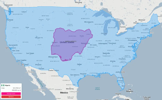
- Nigeria vs. United States: Nigeria is nearly 1.5 times the size of Texas. If placed over the eastern United States, it would stretch from New York to North Carolina and west to Indiana.
- Nigeria vs. Western Europe: Nigeria could contain Spain, France, and the United Kingdom combined, with room to spare for Belgium.
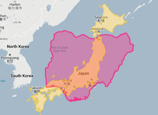
- Nigeria vs. Japan: Nigeria is approximately 2.4 times larger than Japan, despite Japan having about 40% of Nigeria’s population.
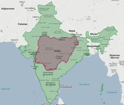
- Nigeria vs. India:
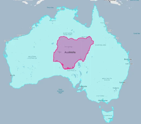
- Nigeria vs. Australia:
Nigeria’s Geographic Diversity: From Desert to Rainforest
Nigeria’s territory encompasses remarkable environmental diversity from north to south:
- Sahel Region: The northernmost part of Nigeria borders the Sahara Desert, featuring arid and semi-arid landscapes
- Savanna Belt: The central portions of northern Nigeria consist of guinea savanna and Sudan savanna, characterized by grasslands with scattered trees
- Middle Belt: This transitional zone between north and south features varied landscapes including the Jos Plateau, a significant highland area
- Rainforest Zone: Southern Nigeria contains tropical rainforests, though much has been cleared for agriculture and urban development
- Niger Delta: The southernmost portion features one of the world’s largest river deltas, with extensive mangrove swamps and wetlands
- Coastline: Nigeria possesses approximately 853 kilometers (530 miles) of coastline along the Gulf of Guinea in the Atlantic Ocean
The Niger River and Its Delta: Lifeblood of West Africa
The Niger River forms Nigeria’s most significant hydrological feature:
- Africa’s third-longest river flows for approximately 1,170 kilometers (730 miles) through Nigeria, entering from the northwest and emptying into the Gulf of Guinea
- The Niger River joins with its major tributary, the Benue River, at Lokoja, creating a distinctive “Y” shape that divides the country
- The Niger Delta, covering about 70,000 square kilometers (27,000 square miles), is one of the world’s largest river deltas and an ecological treasure despite environmental challenges from oil extraction
- This complex delta system contains numerous distributaries, creeks, and mangrove swamps, creating a labyrinthine wetland ecosystem
- The Niger River and its basin support agriculture, fishing, transportation, and hydroelectric power generation for millions of Nigerians
The Jos Plateau: Nigeria’s Highland Center
The Jos Plateau represents Nigeria’s most significant highland region:
- Located in central Nigeria, this elevated granite plateau rises abruptly from the surrounding plains to an average height of about 1,300 meters (4,300 feet) above sea level
- The highest point, Shere Hills, reaches 1,829 meters (6,001 feet)
- The plateau’s temperate climate contrasts with the surrounding lowlands, with average temperatures about 5-7°C (9-13°F) cooler than adjacent areas
- This region contains valuable mineral deposits, including tin, which was extensively mined during the colonial era, leaving distinctive mining ponds across the landscape
- The plateau’s fertile soils support diverse agriculture, including temperate crops uncommon elsewhere in Nigeria, such as potatoes and apples
Lake Chad: Shrinking Transboundary Water
Lake Chad forms part of Nigeria’s northeastern border:
- This shallow lake is shared by four countries: Nigeria, Niger, Chad, and Cameroon
- Once one of Africa’s largest lakes, Lake Chad has shrunk dramatically since the 1960s, with its surface area decreasing by approximately 90% from about 25,000 square kilometers to less than 1,500 square kilometers today
- This severe contraction is attributed to climate change, increased water usage for irrigation, and demographic pressure
- Despite its diminished size, the lake remains crucial for fishing, agriculture, and pastoralism in the region
- The lake’s changing shoreline and diminishing resources have contributed to regional tensions and population displacement
Population Distribution: The World’s Black Demographic Giant
Nigeria’s population pattern shows dramatic demographic dynamics:
- With over 230 million people, Nigeria is Africa’s most populous country, accounting for about one-sixth of the continent’s entire population
- Nigeria has one of the world’s highest average population densities for a large country, with approximately 226 people per square kilometer
- This density varies dramatically by region, with Lagos State exceeding 3,000 people per square kilometer while some northeastern states have fewer than 100 people per square kilometer
- About 53% of Nigerians live in urban areas, with rapid urbanization continuing to transform the country
- Lagos, the largest city with about 22 million inhabitants in its metropolitan area, is one of the world’s fastest-growing megacities and ranks among the largest urban agglomerations globally
Nigeria’s States: Large as European Nations
Many of Nigeria’s 36 states (administrative divisions) are comparable in size to entire countries:
| Nigerian State | Area (km²) | Comparable Country |
|---|---|---|
| Niger | 76,363 | Czech Republic (78,865 km²) |
| Borno | 70,898 | Ireland (70,273 km²) |
| Yobe | 45,502 | Estonia (45,227 km²) |
| Kaduna | 46,053 | Denmark (43,094 km²) |
| Taraba | 54,473 | Croatia (56,594 km²) |
Geography and Climate: Tropical Varieties
Nigeria’s geography creates diverse climatic conditions:
- Located entirely within the tropics, Nigeria experiences high temperatures year-round, with averages between 25-28°C (77-82°F) across most of the country
- The country has two primary seasons: a rainy season (April to October in the south, May to September in the north) and a dry season for the remainder of the year
- Annual rainfall decreases dramatically from south to north, with coastal areas receiving over 3,500 mm (138 inches) annually while the far northeast receives less than 500 mm (20 inches)
- The harmattan, a dry and dusty wind from the Sahara, affects northern Nigeria during the dry season, bringing cooler temperatures but also dust-laden air
- Despite being a tropical country, parts of Nigeria can experience relatively cool temperatures, particularly at higher elevations like the Jos Plateau and during harmattan periods
Natural Resources: Petroleum and Beyond
Nigeria possesses enormous natural resource wealth:
- Nigeria is Africa’s largest oil producer and ranks among the world’s top oil exporters, with most production centered in the Niger Delta region
- The country has the largest natural gas reserves in Africa, estimated at over 200 trillion cubic feet
- Nigeria possesses significant solid mineral deposits, including coal, tin, limestone, columbite, gold, iron ore, lead, and zinc
- The country’s agricultural potential is immense, with fertile soils supporting diverse crops across different ecological zones, from cocoa and rubber in the south to grains and cotton in the north
- Nigeria has substantial renewable energy potential, particularly in solar (especially in the north), hydroelectric power along the Niger and Benue rivers, and wind in specific locations
Biodiversity: From Savannas to Rainforests
Nigeria’s diverse ecosystems support remarkable biodiversity:
- The country is home to approximately 1,340 species of butterflies, 1,000 species of birds, 274 mammal species, 938 species of fish, and over 4,600 plant species
- Nigeria’s varied ecosystems include mangrove forests, rainforests, montane forests, savannas, and semi-desert, each supporting distinct flora and fauna
- Endangered species found in Nigeria include the Cross River gorilla (the world’s rarest great ape), Nigeria-Cameroon chimpanzee, forest elephant, and West African lion
- The Niger Delta constitutes one of the most extensive mangrove ecosystems in Africa, though it faces severe threats from oil pollution and development
- Despite substantial habitat loss, Nigeria maintains several important protected areas, including Gashaka-Gumti National Park, Cross River National Park, and Yankari Game Reserve
Geographic Challenges: Resource Pressures and Climate Change
Nigeria’s geography creates significant development challenges:
- Environmental Degradation: Oil spills in the Niger Delta, deforestation in the south, and desertification in the north have created serious environmental challenges
- Flooding: Seasonal flooding affects many parts of Nigeria, particularly along the Niger and Benue Rivers, with increasingly severe events in recent years
- Drought and Desertification: Northern Nigeria is experiencing advancing desertification, with the Sahara Desert estimated to be moving southward at 0.6 km per year in some areas
- Population Pressure: Nigeria’s rapidly growing population puts intense pressure on land, water, and other resources
- Climate Change: Nigeria is vulnerable to climate change impacts, including more extreme weather events, shifting agricultural zones, and coastal erosion
Nigeria’s National Challenges and Geographic Opportunities
Nigeria’s geography creates both challenges and opportunities:
- Nigeria’s substantial size combined with its colonial-era boundaries created a nation of extraordinary ethnic and cultural diversity, with over 250 ethnic groups and 500+ languages
- The country’s geography has contributed to regional economic disparities, with the oil-rich south having different development patterns than the agricultural north
- Nigeria’s position in West Africa makes it a natural regional leader and hub for transportation, trade, and cultural influence
- The country’s varied ecosystems create opportunities for diverse agricultural production and ecological tourism
- Nigeria’s Gulf of Guinea coastline provides access to global shipping lanes and fishing grounds, though it also faces challenges from coastal erosion and rising sea levels
Explore More Size Comparisons
Curious about how other major countries and continents compare in true size? Check out these related articles:
- The Colossal Truth About Tanzania: East African Giant Larger Than France, Germany and Italy Combined
- The Surprising Scale of Venezuela: South American Powerhouse Larger Than All of France and Germany Together
- The Mind-Blowing True Size of Egypt: Ancient Civilization Larger Than France, Germany and the UK Combined
- The True Size of Africa: A Continent Far Larger Than Maps Suggest
- Complete List of Countries by True Size
Sources & Further Reading
- National Bureau of Statistics, Nigeria. (2023). Statistical Data.
- National Space Research and Development Agency. (2022). Geographic Information.
- CIA World Factbook. (2023). Nigeria.