Tanzania
World Rank: #25
947,300 km²




Tanzania: The Vast Safari Giant Most People Completely Underestimate
Tanzania ranks as the twenty-fifth largest country in the world with a territory of 947,300 square kilometers (365,756 square miles). This massive East African nation is the continent’s thirteenth-largest country, yet its true scale remains consistently underestimated in global consciousness. What’s truly astounding is that Tanzania’s immense expanse could contain France, Germany, and Italy combined—essentially swallowing three of Europe’s largest and most influential nations with room to spare.
What makes Tanzania’s geography extraordinary is its remarkable diversity, featuring Africa’s highest mountain (Kilimanjaro), deepest lake (Tanganyika), largest lake (Victoria), and most famous wildlife ecosystem (Serengeti). From idyllic tropical islands to vast savanna plains and from high mountains to deep lakes, Tanzania encompasses a breathtaking range of landscapes that has earned it the nickname “Africa in miniature.”
Located between approximately 1° and 12° South latitude, Tanzania experiences minimal distortion on standard Mercator projection maps compared to countries at more extreme latitudes. However, psychological biases that lead people to underestimate African countries’ dimensions have contributed to widespread misconceptions about Tanzania’s true size and geographic significance.
Watch Tanzania expand its size as we move it away the equator. We compare it to the USA, Europe, Africa, Greenland, Brazil, Australia, Russia, India, China, etc. You can use this country size comparison interactive map here.
Tanzania’s Massive True Size Will Shock You: Global Perspective
To truly grasp Tanzania’s dimensions, these direct comparisons with familiar countries and regions provide eye-opening context:

Tanzania vs. Western Europe: Tanzania would completely engulf several major European powers combined
| Comparison | Area (km²) | Size Relative to Tanzania |
|---|---|---|
| Tanzania | 947,300 | 1.0 |
| France, Germany, and Italy combined | ~917,000 | ~0.97 times Tanzania’s size |
| Nigeria | 923,768 | 0.98 times Tanzania’s size |
| Texas and Utah combined (US states) | ~955,000 | ~1.01 times Tanzania’s size |
| Spain, United Kingdom, Italy, and Portugal combined | ~928,000 | ~0.98 times Tanzania’s size |
5 Incredible Tanzania Size Comparisons You’ve Never Seen
- Tanzania vs. United States: Tanzania is nearly 1.5 times the size of Texas, America’s second-largest state. If placed over the eastern United States, it would stretch from New York to South Carolina and west past the Mississippi River.

- Tanzania vs. Western Europe: Tanzania could contain France, Germany, Italy, and Denmark combined.
- Tanzania vs. Japan: Tanzania is approximately 2.5 times larger than Japan, despite Japan having more than twice Tanzania’s population.

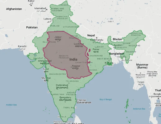
- Tanzania vs. India:
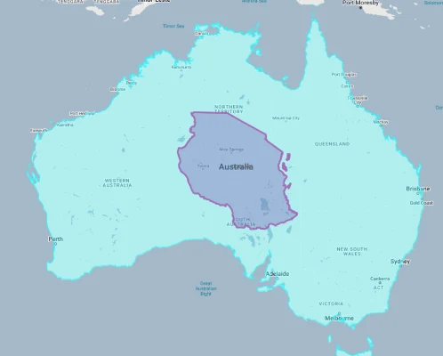
- Tanzania vs. Australia:
Tanzania’s Geographic Diversity: Four Distinct Zones
Tanzania’s territory can be divided into four major geographic regions:
- Coastal Lowlands: The warm, humid strip along the Indian Ocean, including the islands of Zanzibar, Pemba, and Mafia
- Central Plateau: The vast, elevated interior comprising much of the country, characterized by miombo woodland, savanna, and plains
- Highland Areas: Several mountainous regions including the Northern Highlands around Kilimanjaro and Meru, the Southern Highlands, and the Western Highlands near Lake Tanganyika
- Great Rift Valley: The western branch of the East African Rift System runs through western Tanzania, creating a dramatic landscape with deep lakes and escarpments
- Lake Victoria Basin: The northeastern corner of Tanzania borders Lake Victoria, Africa’s largest lake and the primary source of the Nile River
Mount Kilimanjaro: Roof of Africa
Mount Kilimanjaro is Tanzania’s most iconic geographical feature:
- Rising to 5,895 meters (19,341 feet), Kilimanjaro is the highest mountain in Africa and the highest free-standing mountain in the world
- This dormant volcano consists of three distinct volcanic cones: Kibo, Mawenzi, and Shira, with Kibo being the highest and containing the permanent summit glaciers
- Despite being just 300 kilometers (186 miles) from the equator, Kilimanjaro’s summit is crowned with glaciers and snow, though these are rapidly retreating due to climate change
- The mountain rises in splendid isolation from the surrounding plains, creating one of the world’s most dramatic elevational transitions
- Kilimanjaro represents one of the most accessible of the world’s Seven Summits (the highest peaks on each continent), requiring no technical climbing skills though the altitude presents significant challenges
Tanzania’s Great Lakes: Vast Inland Seas
Tanzania contains portions of three of Africa’s largest lakes:
- Lake Victoria, Africa’s largest lake (and the world’s second-largest freshwater lake by area), covers 68,800 square kilometers (26,600 square miles), with about 49% of its southern portion in Tanzania
- Lake Tanganyika, the world’s second-deepest lake (after Lake Baikal), reaches depths of 1,470 meters (4,820 feet) and forms much of Tanzania’s western border
- Lake Nyasa (Lake Malawi), the ninth-largest lake in the world, defines part of Tanzania’s southwestern border
- Together, these three lakes contain approximately 25% of the Earth’s unfrozen surface freshwater
- Tanzania also contains numerous smaller lakes, including Lake Natron in the north, famous for its extreme alkalinity and flocks of flamingos, and Lake Manyara, renowned for its tree-climbing lions
The Serengeti Ecosystem: Wildlife Spectacle
The Serengeti ecosystem represents one of the world’s most important wildlife areas:
- This vast ecosystem covers approximately 30,000 square kilometers (11,600 square miles), mostly within Tanzania (with a small portion extending into Kenya as the Maasai Mara)
- The Serengeti is famous for the annual wildebeest migration, the largest terrestrial mammal migration on Earth, involving approximately 1.5 million wildebeest and hundreds of thousands of zebras and gazelles
- The ecosystem encompasses several protected areas, including Serengeti National Park, Ngorongoro Conservation Area (featuring the world’s largest intact volcanic caldera), and several game reserves
- The Serengeti-Mara ecosystem supports the greatest concentration of plains game in Africa and one of the highest densities of large predators in the world
- This region has immense ecological significance and has been designated a UNESCO World Heritage Site and a Biosphere Reserve
Zanzibar: Spice Islands in the Indian Ocean
The semi-autonomous archipelago of Zanzibar forms a distinctive part of Tanzania:
- Located approximately 25-50 kilometers (15-30 miles) off the mainland coast, Zanzibar consists of two main islands, Unguja (commonly called Zanzibar) and Pemba, plus numerous smaller islands
- The archipelago covers about 2,654 square kilometers (1,025 square miles) and has a distinct history, culture, and political status within Tanzania
- Historically, Zanzibar was the center of the spice and slave trades in East Africa and was controlled by Omani Arabs for centuries before becoming a British protectorate
- The islands merged with Tanganyika in 1964 to form the United Republic of Tanzania, though Zanzibar maintains considerable autonomy
- The archipelago features pristine beaches, coral reefs, and historic Stone Town, a UNESCO World Heritage Site known for its narrow alleys, carved doors, and blend of African, Arab, Indian, and European architectural influences
Population Distribution: Coastal and Lake Concentration
Tanzania’s population pattern shows interesting demographic trends:
- With approximately 65 million people, Tanzania has a moderate average population density of about 69 people per square kilometer
- This density varies dramatically by region, with the highest concentrations along the coast, around Lake Victoria, and in the fertile highlands
- About 38% of Tanzanians live in urban areas, with this percentage steadily increasing through rural-to-urban migration
- Dar es Salaam, the former capital and largest city with about 6.4 million inhabitants, is one of the fastest-growing cities in Africa
- Dodoma, located in the central plateau, became the official capital in 1974, though many government functions remained in Dar es Salaam until the late 2010s when a concerted effort was made to complete the move
Tanzania’s Regions: Large as European Nations
Many of Tanzania’s 31 regions (administrative divisions) are comparable in size to entire countries:
| Tanzanian Region | Area (km²) | Comparable Country |
|---|---|---|
| Tabora | 76,151 | Czech Republic (78,865 km²) |
| Rukwa | 68,635 | Lithuania (65,300 km²) |
| Mbeya | 60,350 | Croatia (56,594 km²) |
| Morogoro | 70,624 | Ireland (70,273 km²) |
| Lindi | 66,046 | Sri Lanka (65,610 km²) |
Geography and Climate: A Land of Contrasts
Tanzania’s diverse geography creates a wide variety of climatic conditions:
- Despite being located entirely within the tropics, Tanzania’s climate varies dramatically due to topography, from hot and humid coastal areas to temperate highlands and semi-arid interior plains
- The country experiences two distinct rainfall patterns: the northern and eastern regions have bimodal rainfall (short rains from October to December and long rains from March to May), while the southern, western, and central regions have a single rainy season from December to April
- Average temperatures range from 25-31°C (77-88°F) along the coast to 15-20°C (59-68°F) in the highlands
- Rainfall varies dramatically, from over 2,000 mm (79 inches) annually in parts of the Southern Highlands and around Mount Kilimanjaro to less than 500 mm (20 inches) in the central plateau
- This climatic diversity supports an extraordinary range of ecosystems, from coral reefs and mangrove forests along the coast to alpine meadows on Kilimanjaro
Biodiversity Hotspot: Land of Mega-Fauna
Tanzania is one of the world’s most important countries for biodiversity:
- The country supports approximately 310 mammal species, including the “Big Five” (lion, elephant, rhino, leopard, and buffalo) and the greatest concentration of large mammals on Earth in the Serengeti ecosystem
- Tanzania is home to about 1,100 bird species, over 100 snake species, and more than 10,000 plant species, many of which are endemic
- The country contains a remarkable variety of ecosystems, including montane forests, miombo woodlands, acacia savannas, coastal forests, mangroves, and alpine zones
- Tanzania has dedicated approximately 38% of its land area to conservation in the form of national parks, game reserves, forest reserves, and other protected areas
- Several UNESCO World Heritage Sites recognize Tanzania’s natural wealth, including Serengeti National Park, Ngorongoro Conservation Area, Selous Game Reserve (now Nyerere National Park), and Kilimanjaro National Park
Natural Resources: Mineral Riches and Agricultural Potential
Tanzania possesses significant natural resources:
- The country is the fourth-largest gold producer in Africa and has significant deposits of diamonds, tanzanite (a blue/purple variety of zoisite found only in Tanzania), uranium, nickel, copper, and other minerals
- Tanzania has discovered substantial natural gas reserves off its southern coast, estimated at over 57 trillion cubic feet
- The fertile volcanic soils in the highlands and around Lake Victoria support diverse agriculture, with coffee, tea, cotton, cashews, tobacco, and sisal among the main export crops
- Forests cover approximately 38 million hectares (38% of land area), though deforestation is a significant concern
- Tanzania’s abundant wildlife, spectacular landscapes, and cultural heritage make tourism a major economic resource, accounting for approximately 17% of GDP and 25% of foreign exchange earnings before the COVID-19 pandemic
Geographic Challenges: Connectivity and Conservation
Tanzania’s geography creates significant development challenges:
- Transportation: The vast size and varied topography make building and maintaining transportation infrastructure challenging, with many rural areas poorly connected
- Drought and Flooding: Climate variability creates challenges for agriculture, with periodic droughts in the central regions and flooding in lowland areas
- Conservation vs. Development: Balancing the needs of a growing population with the preservation of globally significant ecosystems creates policy tensions
- Climate Change: Tanzania is vulnerable to climate change impacts, including glacier retreat on Kilimanjaro, coastal erosion, and altered rainfall patterns
- Land Degradation: Deforestation, soil erosion, and desertification affect various regions, particularly in areas with high population pressure
The Great Rift Valley: Geological Wonder
The Great Rift Valley is a significant geological feature running through western Tanzania:
- Tanzania contains a substantial portion of the western branch of the East African Rift System, a 6,000-kilometer (3,700-mile) crack in the Earth’s crust where the African Plate is splitting into two
- This massive geological fault has created a series of long, narrow lakes including Lake Tanganyika, Lake Rukwa, and Lake Nyasa (Malawi) within Tanzania
- The rift is bordered by high escarpments and mountains, creating spectacular scenery with dramatic elevation changes
- Volcanic activity associated with the rift has created notable features like the Ngorongoro Crater, a 600-meter (2,000-foot) deep caldera spanning 260 square kilometers (100 square miles)
- The rift valley in Tanzania continues to be seismically active, with occasional earthquakes and ongoing geological processes that are slowly splitting the African continent
Explore More Size Comparisons
Curious about how other major countries and continents compare in true size? Check out these related articles:
- The Mind-Blowing True Size of Egypt: Ancient Civilization Larger Than France, Germany and the UK Combined
- The Unexpected Scale of Nigeria: West African Powerhouse Larger Than Turkey and Germany Combined
- The Surprising Scale of Ethiopia: Ancient Highland Empire Larger Than France and Spain Combined
- The True Size of Africa: A Continent Far Larger Than Maps Suggest
- Complete List of Countries by True Size
Sources & Further Reading
- National Bureau of Statistics, Tanzania. (2023). Statistical Data.
- Tanzania National Parks Authority (TANAPA). (2022). Protected Areas Information.
- CIA World Factbook. (2023). Tanzania.