Indonesia
World Rank: #15
1,904,569 km²






Indonesia: The World’s Largest Archipelagic Nation
Indonesia ranks as the fifteenth-largest country in the world with a land area of 1,904,569 square kilometers (735,358 square miles). What makes Indonesia truly remarkable is that this vast territory is spread across more than 17,000 islands stretching along the equator for over 5,000 kilometers (3,100 miles) from east to west. This archipelagic nation effectively bridges Asia and Australia, creating a unique geographic position between the Indian and Pacific Oceans.
Unlike most large countries that consist primarily of contiguous landmasses, Indonesia’s territory is fragmented across numerous islands, creating one of the world’s longest coastlines at approximately 54,720 kilometers (34,000 miles). Despite this fragmentation, Indonesia’s land area is comparable to combined territories of France, Germany, and the United Kingdom.
Located directly along the equator, Indonesia experiences minimal distortion on standard Mercator projection maps. However, the country’s sprawling archipelagic nature means that global maps often fail to convey the true scale and complexity of Indonesia’s geography, particularly when it comes to the thousands of smaller islands that make up this diverse nation.
Watch Indonesia shrink to its actual size as we move it toward the equator. We compare it to the USA, Europe, Africa, Russia, Greenland, Brazil, Australia, India, China, etc. You can use this country size comparison interactive map here.
Indonesia’s True Size in Global Perspective
To better understand Indonesia’s dimensions, direct comparisons with other countries and regions provide valuable context:

Indonesia vs. Europe: Indonesia’s east-to-west span is comparable to the distance from London to Moscow
| Comparison | Area (km²) | Size Relative to Indonesia |
|---|---|---|
| Indonesia | 1,904,569 | 1.0 |
| Mexico | 1,964,375 | 1.03 times Indonesia’s size |
| France, Germany, and UK combined | ~1,882,000 | ~0.99 times Indonesia’s size |
| Alaska (US state) | 1,717,854 | 0.90 times Indonesia’s size |
| Libya | 1,759,540 | 0.92 times Indonesia’s size |
5 Surprising Indonesia Size Comparisons
- Indonesia vs. United States: If superimposed on the United States, Indonesia would stretch roughly from San Francisco to Chicago.

- Indonesia vs. Western Europe: Indonesia’s total land area is nearly equivalent to France, Germany, and the United Kingdom combined.
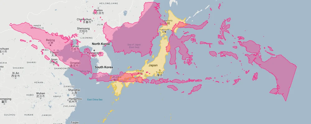
- Indonesia vs. Japan: Indonesia is approximately 5 times larger than Japan in land area.
- Indonesia’s East-West Span: Indonesia’s east-to-west span is equivalent to the distance from London to Baghdad, or New York to Denver.
- Indonesia vs. Russia:

Indonesia’s Geographic Diversity: Islands Beyond Counting
Indonesia’s extraordinary geographic diversity is characterized by:
- Island Abundance: With over 17,000 islands (approximately 6,000 inhabited), Indonesia is the world’s largest archipelagic state
- Major Islands: The country includes several of the world’s largest islands, including Sumatra (473,481 km²), Borneo (shared with Malaysia and Brunei; Indonesian portion: 539,460 km²), Papua (shared with Papua New Guinea; Indonesian portion: 319,036 km²), and Java (138,794 km²)
- Active Volcanoes: Indonesia contains approximately 150 active volcanoes, more than any other country, forming part of the Pacific Ring of Fire
- Rainforests: The country possesses the third-largest area of tropical rainforest in the world, after Brazil and the Democratic Republic of Congo
- Marine Biodiversity: Indonesia’s waters include much of the Coral Triangle, the global epicenter of marine biodiversity
Java: The Demographic Heart of Indonesia
Java is Indonesia’s most significant island in terms of population and economic activity:
- Despite comprising only about 7% of Indonesia’s total land area, Java is home to approximately 56% of the country’s population – nearly 150 million people
- With a population density exceeding 1,100 people per square kilometer, Java is one of the most densely populated large islands in the world
- Jakarta, the capital and largest city, is located on Java and forms the center of a metropolitan area with more than 30 million inhabitants
- The island’s fertile volcanic soil supports intensive agriculture, particularly rice cultivation
- In 2022, Indonesia announced plans to relocate its capital from Jakarta to a new planned city called Nusantara on the island of Borneo, partly due to Java’s overcrowding and Jakarta’s vulnerability to flooding
Population Distribution: Island Disparities
Indonesia’s population distribution shows dramatic variations across its archipelago:
- With approximately 275 million people, Indonesia is the world’s fourth most populous country
- Population density varies dramatically from over 15,000 people per square kilometer in parts of Jakarta to fewer than 10 people per square kilometer in parts of Papua
- Nearly 60% of Indonesians live on Java, despite it being only the country’s fifth-largest island by area
- About 56% of Indonesia’s population lives in urban areas, a percentage that has been steadily increasing
- The demographic center of Indonesia has been shifting eastward as development spreads from Java to the outer islands
Indonesia’s Major Islands: Each Comparable to Countries
Indonesia’s largest islands are each comparable in size to significant countries:
| Indonesian Island | Area (km²) | Comparable Country |
|---|---|---|
| Borneo (Indonesian portion: Kalimantan) | 539,460 | France (543,940 km²) |
| Sumatra | 473,481 | Sweden (450,295 km²) |
| Papua (Indonesian portion) | 319,036 | Poland (312,696 km²) |
| Sulawesi | 174,600 | Syria (185,180 km²) |
| Java | 138,794 | Greece (131,957 km²) |
Geography and Climate: The Equatorial Position
Indonesia’s position straddling the equator creates distinctive climatic conditions:
- The equator runs through the islands of Sumatra, Borneo, Sulawesi, and Halmahera, placing the country in the humid tropical zone
- Most of Indonesia experiences two seasons: a wet monsoon season (October to April) and a dry season (May to September), with regional variations
- Temperatures remain relatively constant throughout the year, with lowland areas averaging 25-27°C (77-81°F)
- Highland areas, particularly in Papua, can reach much cooler temperatures and even contain equatorial glaciers on Puncak Jaya, though these are rapidly retreating due to climate change
- Indonesia’s climate diversity contributes to its status as one of the world’s 17 megadiverse countries, containing approximately 10% of the world’s plant species and 12% of all mammal species
The Indonesian Throughflow: Vital Global Ocean Current
Indonesia’s geographic position creates a crucial ocean passage:
- The Indonesian Throughflow is a series of ocean currents that carry water from the Pacific Ocean to the Indian Ocean through Indonesia’s archipelago
- This oceanic passageway transfers approximately 15 million cubic meters of water per second, making it a significant component of global ocean circulation
- The Throughflow influences climate patterns across the Indo-Pacific region and affects global climate systems
- Key straits involved include the Makassar Strait between Borneo and Sulawesi, and the Lombok Strait between Bali and Lombok
- The complex underwater topography of Indonesia’s seas, including deep ocean trenches and shallower continental shelves, creates unique oceanographic conditions that support extraordinary marine biodiversity
Natural Resources: Wealth Above and Below Ground
Indonesia’s diverse territory contains abundant natural resources:
- Indonesia possesses significant petroleum and natural gas reserves, particularly in Sumatra, Kalimantan, and offshore fields
- The country is a major producer of coal, tin, nickel, gold, and copper
- Indonesia’s vast forests, though experiencing significant deforestation, still represent one of the world’s largest tropical forest areas
- The country is the world’s largest producer of palm oil, with extensive plantations particularly in Sumatra and Kalimantan
- Indonesia’s territorial waters contain rich fisheries and significant potential for renewable marine energy
Geographic Hazards: Living on the Ring of Fire
Indonesia’s position on the Pacific Ring of Fire creates significant natural hazards:
- Volcanic Eruptions: With around 150 active volcanoes, Indonesia experiences frequent eruptions, including catastrophic events such as the 1883 eruption of Krakatoa
- Earthquakes: Indonesia sits at the meeting point of several tectonic plates, making it highly prone to earthquakes, including the devastating 2004 Indian Ocean earthquake that triggered a catastrophic tsunami
- Tsunamis: Indonesia’s coastlines are vulnerable to tsunamis generated by seismic activity, with recent devastating examples in Aceh (2004), Palu (2018), and the Sunda Strait (2018)
- Floods and Landslides: Heavy monsoon rains combined with deforestation have increased the frequency of floods and landslides across the archipelago
- Sea Level Rise: As an archipelagic nation, Indonesia is particularly vulnerable to climate change-induced sea level rise, with Jakarta already experiencing significant subsidence combined with rising waters
Explore More Size Comparisons
Curious about how other major countries and continents compare in true size? Check out these related articles:
- The True Size of Mexico: A Land of Geographic Diversity
- The Real Size of Peru: South America’s Third-Largest Nation
- The Real Size of India: Seventh Largest But Home to One-Sixth of Humanity
- Complete List of Countries by True Size
Sources & Further Reading
- Badan Pusat Statistik (Statistics Indonesia). (2023). Geographic and Demographic Data.
- Badan Informasi Geospasial (Geospatial Information Agency). (2022). Indonesia Geographic Information.
- CIA World Factbook. (2023). Indonesia.