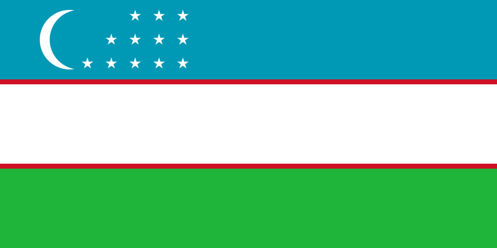
Uzbekistan
World Rank: #44
447,400 km²



Next Smaller Country
(Rank #45)
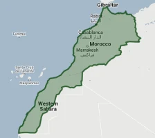
Morocco
446,550 km²
Uzbekistan: Central Asia’s Double-Landlocked Nation
Uzbekistan ranks as the forty-fourth largest country in the world with a territory of 447,400 square kilometers (172,700 square miles). Located in the heart of Central Asia, Uzbekistan stands as one of only two double-landlocked countries in the world (the other being Liechtenstein)—meaning it is completely surrounded by countries that are themselves landlocked.
What makes Uzbekistan geographically remarkable is its dramatic contrast between fertile river valleys and harsh deserts. The country contains some of Central Asia’s oldest and most magnificent cities along the ancient Silk Road, while also encompassing portions of both the Kyzylkum and Karakum deserts and the rapidly disappearing Aral Sea—one of the world’s worst environmental disasters. This geographic diversity has shaped Uzbekistan’s development as a cultural and economic crossroads for millennia.
Located between approximately 37° and 46° North latitude, Uzbekistan experiences moderate distortion on standard Mercator projection maps. While its dimensions are represented fairly accurately on most world maps, its central position in the Eurasian landmass often leaves it overlooked in global-scale representations.
Let’s explore how Uzbekistan’s true size compares to other major countries and regions, and what makes this Central Asian nation geographically unique.
Watch Uzbekistan shrink to its actual size as we move it toward the equator. We compare it to the USA, Europe, Africa, Greenland, Brazil, Australia, Russia, India, China, etc. You can use this country size comparison interactive map here.
Uzbekistan’s True Size in Global Perspective
To better understand Uzbekistan’s dimensions, direct comparisons with other countries and regions provide valuable context:

Uzbekistan vs. Western Europe: Uzbekistan is comparable in size to Sweden
| Comparison | Area (km²) | Size Relative to Uzbekistan |
|---|---|---|
| Uzbekistan | 447,400 | 1.0 |
| Sweden | 450,295 | 1.01 times Uzbekistan’s size |
| Germany | 357,022 | 0.80 times Uzbekistan’s size |
| California (US state) | 423,970 | 0.95 times Uzbekistan’s size |
| Japan | 377,975 | 0.84 times Uzbekistan’s size |
5 Surprising Uzbekistan Size Comparisons
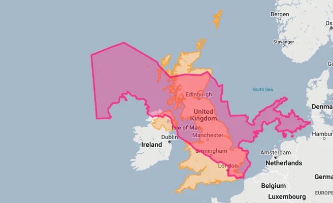
- Uzbekistan vs. United Kingdom: Uzbekistan is approximately 1.85 times larger than the United Kingdom (242,495 km²), despite receiving far less international attention.
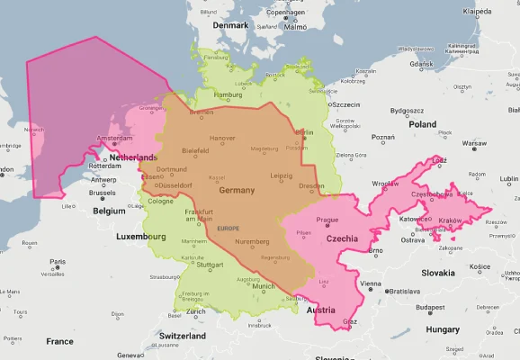
- Uzbekistan vs. Germany: Uzbekistan is approximately 1.25 times larger than Germany (357,022 km²), Europe’s most populous country.
- Uzbekistan vs. California: Uzbekistan is about 6% larger than California (423,970 km²), the third-largest U.S. state.

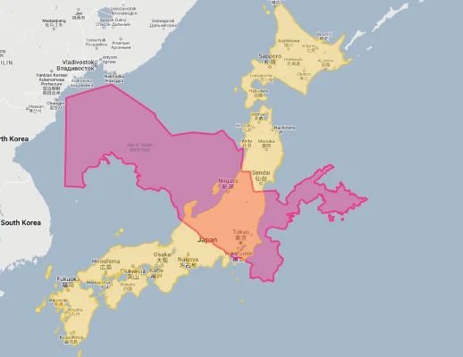
- Uzbekistan vs. Japan: Uzbekistan is 18% larger than Japan (377,975 km²), despite Japan having a population over four times larger.
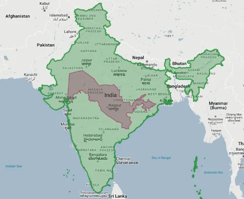
- Uzbekistan vs. India:
Uzbekistan’s Geographic Diversity: Deserts to Oases
Uzbekistan features a remarkable variety of landscapes:
- Deserts: The Kyzylkum (Red Sand) Desert covers much of the northwest, while portions of the Karakum (Black Sand) Desert extend into the country’s south
- Mountain Foothills: The eastern and southeastern regions include foothills of the Tian Shan and Pamir mountain ranges, with elevations reaching 4,643 meters (15,233 feet) at Khazret Sultan
- River Valleys: The fertile valleys of the Amu Darya, Syr Darya, and their tributaries create green corridors through the arid landscape
- The Aral Sea Basin: Once the world’s fourth-largest inland sea, the Aral Sea has shrunk dramatically due to water diversions, leaving behind a salt-encrusted basin in western Uzbekistan
- Fergana Valley: This densely populated, fertile valley is surrounded by mountains and forms Uzbekistan’s agricultural heartland
The Fergana Valley: Uzbekistan’s Agricultural Core
The Fergana Valley represents one of Central Asia’s most significant geographic features:
- This triangular-shaped valley spans approximately 22,000 square kilometers (8,500 square miles) and is shared between Uzbekistan, Kyrgyzstan, and Tajikistan
- The valley is surrounded by mountain ranges—the Tian Shan to the north and the Gissar-Alai to the south—creating a naturally enclosed basin
- Fed by the Syr Darya River and its tributaries, the valley features rich alluvial soils that have supported intensive agriculture for millennia
- The Uzbek portion of the Fergana Valley is divided into three provinces (Andijan, Fergana, and Namangan) and contains approximately 28% of Uzbekistan’s population despite covering only about 5% of its territory
- The valley’s agricultural productivity, particularly for cotton and fruit, has made it economically vital but also contributed to water management challenges throughout the region
Population Distribution: Oasis Concentration
Uzbekistan’s population distribution reflects its challenging geography:
- With approximately 35 million people, Uzbekistan has a moderate average population density of about 79 people per square kilometer
- This density varies dramatically, with the Fergana Valley having densities over 500 people per square kilometer, while vast desert regions have fewer than 1 person per square kilometer
- About 50% of Uzbeks live in urban areas, a proportion that is steadily increasing
- The capital, Tashkent, houses over 2.4 million people in the city proper and approximately 3 million in its metropolitan area – about 9% of the country’s population
- Population is generally concentrated along river valleys and oases, with historical Silk Road cities like Samarkand, Bukhara, and Khiva forming population centers for centuries
Uzbekistan’s Regions: Some Comparable to European Countries
Uzbekistan is divided into 12 provinces (viloyats), one autonomous republic (Karakalpakstan), and one independent city (Tashkent):
| Uzbek Region | Area (km²) | Comparable Country |
|---|---|---|
| Republic of Karakalpakstan | 166,590 | Tunisia (163,610 km²) |
| Navoi Province | 110,800 | Bulgaria (110,994 km²) |
| Bukhara Province | 40,320 | Switzerland (41,285 km²) |
| Kashkadarya Province | 28,570 | Albania (28,748 km²) |
| Samarkand Province | 16,770 | Kuwait (17,818 km²) |
Geography and Climate: Continental Extremes
Uzbekistan’s landlocked position creates a continental climate with extreme variations:
- The country experiences a classic continental climate with long, hot summers and cold winters
- Summer temperatures regularly exceed 40°C (104°F) in desert and lowland areas, while winter temperatures can drop below -20°C (-4°F) in northern regions
- Precipitation is generally sparse, with annual rainfall averaging between 100-200 mm (4-8 inches) in desert regions and up to 800 mm (31 inches) in mountain foothills
- Rainfall is concentrated in winter and spring, with summers typically being very dry
- The country experiences over 300 sunny days per year in many regions, creating significant potential for solar energy
International Borders: Central Asian Crossroads
Uzbekistan is the only country that borders all four other Central Asian states plus Afghanistan:
- Uzbekistan shares borders with Kazakhstan (2,203 km), Turkmenistan (1,793 km), Afghanistan (144 km), Tajikistan (1,312 km), and Kyrgyzstan (1,314 km)
- As a double-landlocked country, Uzbekistan must cross at least two borders to reach the ocean, creating significant challenges for international trade
- The borders were established during the Soviet era and often create complex enclaves and exclaves, particularly in the Fergana Valley
- The Aral Sea, once shared between Uzbekistan and Kazakhstan, has significantly receded, altering the effective border
- Border management has improved in recent years with all neighbors, facilitating increased regional trade and movement
Water Resources: Life-Giving Rivers
In this arid region, water resources are Uzbekistan’s most precious asset:
- The two major rivers are the Amu Darya (2,620 km) and the Syr Darya (2,212 km), which historically flowed to the Aral Sea
- Extensive irrigation networks, some dating back thousands of years and others developed during the Soviet era, have diverted water from these rivers for agriculture
- Uzbekistan contains approximately 17,700 km of irrigation canals, including the massive Karakum Canal
- Both major rivers originate outside Uzbekistan, creating complex transboundary water management challenges with upstream countries
- Water scarcity is a significant issue, with the country using over 90% of its water resources for agriculture, particularly cotton cultivation
The Aral Sea Crisis: An Environmental Catastrophe
Uzbekistan is home to one of the world’s most severe environmental disasters:
- The Aral Sea, once the world’s fourth-largest inland body of water, has lost over 90% of its volume since the 1960s due to water diversions for cotton irrigation
- The Uzbek portion of the Aral Sea is now essentially a dry salt flat, though small water bodies remain in the northern (Kazakh) section
- The former seaport of Muynak now sits more than 150 kilometers (93 miles) from the current shoreline, with abandoned fishing boats resting on desert sand
- The exposed seabed has created a toxic salt desert covering approximately 38,000 square kilometers (14,670 square miles), with salt and dust storms affecting human health across the region
- Climate change has been exacerbated in the region, with more extreme temperatures and altered precipitation patterns following the sea’s disappearance
Natural Resources: Beyond Cotton
Uzbekistan’s varied territory contains diverse natural resources:
- Mineral resources include gold (with Uzbekistan ranking as the world’s ninth-largest producer), uranium, silver, copper, zinc, lead, and tungsten
- The country has substantial natural gas reserves, estimated at 1.1 trillion cubic meters, making it self-sufficient in this energy resource
- Agricultural resources are significant in irrigated areas, with cotton (known as “white gold”) historically being the dominant crop, though diversification has increased
- Solar energy potential is substantial, with many regions receiving over 3,000 hours of sunshine annually
- Water resources, though stressed, remain vital for the country’s development and have shaped settlement patterns throughout history
Geographic Hazards: Earthquakes and More
Uzbekistan’s geographic position exposes it to various natural hazards:
- Earthquakes: Uzbekistan lies in a seismically active zone, with the devastating 1966 Tashkent earthquake (magnitude 7.5) destroying much of the capital city
- Drought: The arid climate makes many regions vulnerable to periodic drought conditions, affecting agriculture and water supplies
- Dust Storms: Desertification and the Aral Sea’s desiccation have increased the frequency and intensity of dust and salt storms
- Landslides: Mountain and foothill regions, particularly in the east, are susceptible to landslides during periods of heavy rainfall
- Flooding: Flash floods can occur in mountain valleys during spring snowmelt or intense rainfall events
Sources & Further Reading
- State Committee of the Republic of Uzbekistan on Statistics. (2023). Geographic Data on Uzbekistan.
- International Fund for Saving the Aral Sea. (2022). Aral Sea Basin Program.
- CIA World Factbook. (2023). Uzbekistan.