Norway
World Rank: #61
385,207 km² (148,729 sq mi)


Next Smaller Country
(Rank #62)
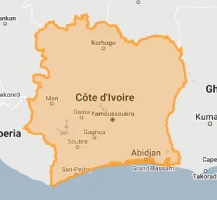
Ivory Coast
322,463 km² (124,504 sq mi)
Norway: The Arctic Nation That Maps Get Completely Wrong
Ever wondered why Norway looks enormous on world maps? It’s not your imagination—it’s one of the most dramatically distorted countries on standard maps, appearing up to 400% larger than its actual size in the far north!
Welcome to the truth about Norway’s dimensions—a fascinating Nordic nation that ranks 61st globally with 385,207 square kilometers (148,729 square miles) of territory. Despite this moderate size ranking, Norway’s extraordinary north-south stretch creates an optical illusion that few other countries experience.
Throughout this article, we’ll drag Norway across the map to reveal its authentic proportions compared to other countries. The visual transformation is truly mind-boggling—especially when you see how the northernmost regions shrink dramatically when moved toward the equator!
Norway extends from 58° all the way to 71° North latitude—with its northernmost territory, Svalbard, reaching a staggering 81° North (just 9 degrees from the actual North Pole). This extreme northern position creates some of the worst map distortion on Earth, making this long, slender country appear deceptively massive.
Ready to discover Norway’s genuine size and see how map projections have been fooling us all? Here a video made with our interactive tool (adjusts for Mercator projection distortion) that shows how big Norway really is:
Watch Norway dramatically shrink as we move it from its high northern latitude toward the equator. We compare it to the USA, Europe, Africa, Brazil, Australia, and other regions. You can use this country size comparison interactive map here.
Norway’s True Size in Global Perspective
To better understand Norway’s actual dimensions, these comparisons with familiar regions provide eye-opening context:

Norway vs. Germany: Norway is slightly larger than Germany, though it appears much bigger on standard maps
| Comparison | Flag | Area (km²) | Size Relative to Norway |
|---|---|---|---|
| Norway | |
385,207 | 1.0 |
| Japan |  |
377,975 | 0.98 times Norway’s size |
| Germany |  |
357,022 | 0.93 times Norway’s size |
| Montana (US state) |  |
380,800 | 0.99 times Norway’s size |
| Zimbabwe |  |
390,757 | 1.01 times Norway’s size |
4 Surprising Norway Size Comparisons
- Norway vs. California: Norway is about 92% the size of California (423,970 km²), though on world maps it often appears larger due to its high latitude.

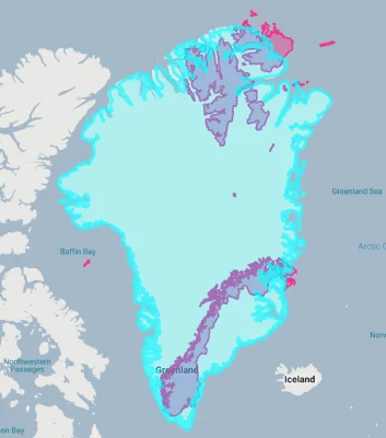
- Norway vs. Greenland:
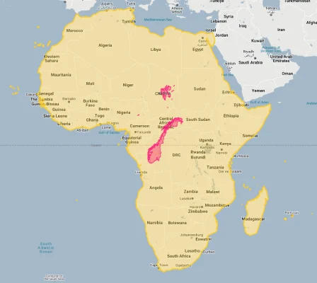
- Norway vs. Africa:
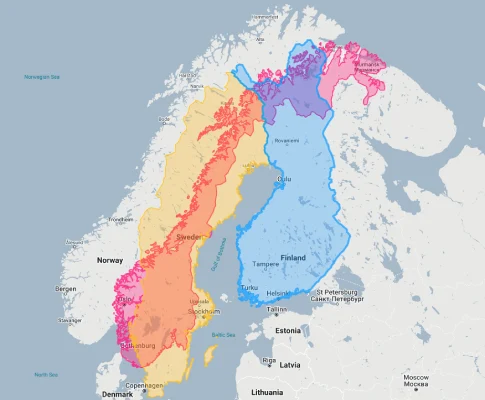
- Norway vs. Nordic Neighbors: Norway is smaller than Sweden (450,295 km²) but larger than Finland (338,424 km²), creating a middle ground among its Nordic neighbors.
The Great Norwegian Distortion: How Maps Misrepresent the North
Norway’s unique geography creates extraordinary map distortion:
- The Extreme Latitude Effect: Norway stretches from 58°N to 71°N, with its Svalbard territory extending to a staggering 81°N—just 9 degrees from the North Pole itself. This placement creates colossal distortion on Mercator maps, where areas near the poles are dramatically magnified
- The Deceptive Northern Regions: Norway’s northernmost county, Finnmark, appears nearly three times its actual size on standard maps. When moved to equatorial latitudes, this region shrinks dramatically, revealing its true proportions
- The Svalbard Illusion: The Svalbard archipelago (61,022 km²) looks enormous on world maps but is actually smaller than West Virginia. The distortion is so extreme that on some maps, Svalbard appears larger than the entire southern half of mainland Norway
- The Elongated Shape Factor: Norway’s unique shape—stretching over 1,752 kilometers (1,089 miles) from north to south but only 430 kilometers (267 miles) at its widest point—creates an impression of greater size than comparably-sized but more compact countries
- The Psychological Impact: This persistent map distortion shapes how Norwegians and others perceive the country’s global importance and relative size. Many visitors express surprise at the actual distances when traveling through Norway
Norway’s Geographic Identity: Land of Mountains and Fjords
Norway’s dramatic landscape forms a unique geographic signature:
- Dramatic Fjords: Norway’s coastline spans an astonishing 25,148 kilometers (15,626 miles) when including all fjords and islands—longer than the circumference of the Earth at the equator! The spectacular Sognefjord extends 204 kilometers (127 miles) inland and reaches depths of 1,300 meters (4,265 feet)
- Mountainous Terrain: Mountains cover two-thirds of Norway’s landmass, with the highest peak being Galdhøpiggen at 2,469 meters (8,100 feet). This predominantly rugged landscape leaves just 3% of the country suitable for agriculture
- Glacier Country: Norway is home to nearly 1,700 glaciers covering about 2,200 square kilometers (850 square miles), with Jostedalsbreen being the largest in continental Europe at 474 square kilometers (183 square miles)
- Arctic Wilderness: Svalbard, located halfway between mainland Norway and the North Pole, contains some of Europe’s largest untouched wilderness areas, where polar bears outnumber humans
- Island Nation: Norway includes over 240,000 islands, making it one of the world’s most island-rich countries. The Lofoten archipelago alone contains stunning landscapes that draw visitors from around the globe
Population Distribution: One of Europe’s Most Sparsely Populated Nations
Norway’s inhabitants are clustered in specific regions, leaving vast areas nearly empty:
- With approximately 5.4 million people across 385,207 square kilometers, Norway maintains one of Europe’s lowest population densities at just 14 people per square kilometer (36 per square mile)—compared to the Netherlands at 508 people per square kilometer
- This density varies dramatically: Oslo exceeds 1,500 people per square kilometer while Finnmark in the far north has a mere 2 people per square kilometer—making parts of northern Norway among Europe’s most isolated inhabited regions
- About 83% of Norwegians live in urban areas, with the Oslo metropolitan region alone home to approximately 1.5 million people—nearly 30% of the entire nation’s population
- The majority of settlements cluster along the coast, with interior mountain regions and the far north remaining largely uninhabited except for scattered communities
- In Svalbard, just 2,667 people inhabit an archipelago of 61,022 square kilometers—creating a population density of 0.044 people per square kilometer, making it one of the world’s most sparsely populated territories
Norway’s Counties: Administrative Geography
Norway is divided into 11 counties (fylker), each with unique characteristics:
| Norwegian County | Area (km²) | Comparable Area |
|---|---|---|
| Troms og Finnmark (largest county) | 74,829 | Slightly smaller than Ireland (70,273 km²) |
| Nordland | 38,155 | Similar to Bhutan (38,394 km²) |
| Innlandet | 52,072 | Similar to Costa Rica (51,100 km²) |
| Viken | 24,593 | Similar to Macedonia (25,713 km²) |
| Oslo (smallest county) | 454 | Similar to Andorra (468 km²) |
Geography and Climate: The Land of the Midnight Sun
Norway’s high latitude creates distinctive environmental conditions:
- Despite its northern location, Norway enjoys a climate that’s milder than expected thanks to the warming influence of the Gulf Stream, which makes the Norwegian coast up to 20°C warmer than other places at the same latitude
- In areas above the Arctic Circle, the sun doesn’t set for approximately 76 days during summer (midnight sun) and doesn’t rise for about 58 days during winter (polar night)
- Average July temperatures range from 12°C to 18°C (54°F to 64°F) across much of the country, while January averages range from -3°C in Oslo to -15°C (5°F) in the interior highlands
- Annual precipitation varies dramatically, with Bergen on the western coast receiving an average of 2,250 mm (89 inches) of rainfall annually—making it one of Europe’s wettest cities—while eastern valleys may receive as little as 300 mm (12 inches)
- Climate change is affecting Norway more rapidly than many regions, with Arctic areas warming at more than twice the global average rate. The Norwegian mainland has warmed by approximately 1°C since 1900, with more pronounced warming in the north
Borders and Maritime Claims: A Strategic Arctic Nation
Norway’s position gives it strategic importance in Northern Europe:
- Norway shares a 1,619-kilometer (1,006-mile) land border with three countries: Sweden (1,630 km), Finland (736 km), and Russia (196 km)—with the Russian border representing an important NATO-Russia frontier
- With its enormous coastline stretching 25,148 kilometers (15,626 miles) including all fjords and islands, Norway maintains a crucial Atlantic maritime presence
- Norway controls the second-largest Exclusive Economic Zone in Europe at 2,385,178 km² (921,174 sq mi)—larger than the combined land area of France, Germany, Spain, and Italy
- The strategic Svalbard archipelago gives Norway sovereignty over territories just 1,050 kilometers (650 miles) from the North Pole, though under the unique Svalbard Treaty of 1920, citizens of all 46 signatory nations have equal rights to engage in commercial activities there
- Norway’s northernmost waters include important shipping lanes that are becoming increasingly accessible due to Arctic ice melt, potentially establishing new maritime routes between Europe and Asia
Natural Resources: Ocean Wealth and Hydropower
Norway’s landscape provides distinctive natural resources:
- Oil and Gas: Norway’s continental shelf contains extensive petroleum reserves, making Norway the 7th largest oil exporter and 3rd largest natural gas exporter globally—resources that have transformed the formerly modest economy into one of the world’s wealthiest
- Hydroelectric Power: The country’s mountainous terrain and abundant rainfall have enabled Norway to develop Europe’s largest hydropower capacity, generating 98% of its electricity from renewable sources
- Fisheries: Norway’s extensive coastline supports one of the world’s most productive fishing industries, with exports reaching over 2.7 million tonnes of seafood annually
- Minerals: Norway possesses significant deposits of industrial minerals, including limestone, olivine, iron, titanium, and nickel
- Forests: Approximately 37% of Norway’s land area is forested, providing timber resources and supporting biodiversity
Geographic Challenges: Mountains, Climate, and Isolation
Norway’s environment creates specific challenges:
- Mountainous Terrain: Norway’s dramatic topography makes transportation infrastructure development especially challenging and expensive. The country has invested heavily in tunnels—over 1,100 road tunnels including the world’s longest road tunnel at 24.5 kilometers (15.2 miles)
- Harsh Winter Conditions: Extreme cold, heavy snowfall, and limited daylight during winter months create significant challenges for transportation, agriculture, and energy demands
- Natural Hazards: Avalanches, landslides, and flooding represent persistent risks in many parts of the country, particularly in fjord and mountain regions
- Remote Communities: Maintaining services and infrastructure for isolated settlements, particularly in the far north and along the complex coastline, requires substantial investment per capita
- Climate Change: Rising temperatures are affecting Norway’s glaciers, ecosystem stability, and traditional ways of life, particularly for indigenous Sami communities in the north
Explore More Size Comparisons
Curious about how other major countries and regions compare in true size? Check out these related articles:
- The True Size of Sweden: Nordic Nation Larger Than Most Realize
- The Real Size of Finland: Northern European Giant
- The Real Size of Iceland: Island Nation Punching Above Its Weight
- Complete List of Countries by True Size
Sources & Further Reading
- Statistics Norway. (2023). Nature and Environment.
- Norwegian Mapping Authority. (2022). Geographical Information.
- CIA World Factbook. (2023). Norway.