Belarus
World Rank: #85
207,600 km² (80,155 sq mi)

Next Larger Country
(Rank #84)
Kyrgyzstan
199,951 km² (77,202 sq mi)
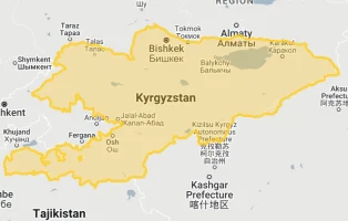
Next Smaller Country
(Rank #86)
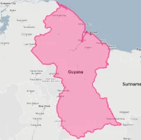
Guyana
214,969 km² (83,000 sq mi)

Belarus: The Forest-Rich Heartland of Eastern Europe
Did you know Belarus contains 40% of Europe’s last remaining primeval forest? Or that this landlocked nation is almost perfectly rectangular and roughly the same size as Kansas?
Welcome to Belarus – Eastern Europe’s hidden geographical treasure. Ranking 85th globally with 207,600 square kilometers (80,155 square miles), Belarus is just 13% smaller than the United Kingdom but houses less than 1/7th of its population. This forested nation shares roughly the same size as Senegal and Kyrgyzstan, though these comparisons rarely enter public consciousness.
In this article, we’ll drag Belarus across the map to reveal how this Eastern European country truly measures up against other nations. Located between 51°N and 56°N latitude, Belarus experiences minimal map distortion on standard projections, meaning its representation on world maps is relatively accurate – a compact, nearly rectangular territory nestled between Russia, Ukraine, Poland, Lithuania, and Latvia.
Despite its moderate dimensions, Belarus packs extraordinary environmental significance into its borders, containing Europe’s largest old-growth forest ecosystem and sprawling wetlands that earn it the nickname “The Lungs of Europe.” Its terrain is predominantly flat, with 70% of the country lying less than 200 meters above sea level, creating vast swathes of marshy lowlands interspersed with over 11,000 lakes and 20,800 rivers.
World maps lie a bit (due to Mercator projection distortion). Here is how big Belarus really is, if we apply resize the country on the map to get account for Mercator projection distortion:
Watch how Belarus compares when overlaid on other countries. We’ve moved it across the USA, Western Europe, Australia, and many other nations to reveal its true proportions. You can use this country size comparison interactive map here.
7 Surprising Belarus Size Facts
- Belarus is almost exactly the same size as Kansas (213,100 km²)
- You could fit 20 Luxembourgs inside Belarus
- Belarus is 13% smaller than the United Kingdom but has only 9.4 million people
- The country is 80 times smaller than Russia, its eastern neighbor
- Belarus covers just 2.1% of Europe’s total land area but contains 40% of its remaining primeval forest
- Belarus is approximately twice the size of Portugal (92,212 km²)
- The country contains 11,000 lakes despite being smaller than 12 U.S. states
Belarus’s True Size in Global Perspective
To appreciate Belarus’s actual dimensions, these direct comparisons with familiar regions offer eye-opening context:
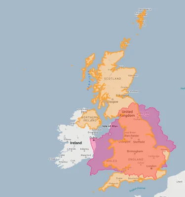
Belarus vs. United Kingdom: Belarus is approximately 13% smaller than the UK (207,600 km² vs. 242,495 km²)
| Comparison | Flag | Area (km²) | Size Relative to Belarus |
|---|---|---|---|
| Belarus | |
207,600 | 1.0 |
| United Kingdom |  |
242,495 | 1.17 times Belarus’s size |
| Senegal |  |
196,722 | 0.95 times Belarus’s size |
| Kansas (US state) |  |
213,100 | 1.03 times Belarus’s size |
| Guyana | |
214,969 | 1.04 times Belarus’s size |
| Syria |  |
185,180 | 0.89 times Belarus’s size |
| Portugal |  |
92,212 | 0.44 times Belarus’s size |
5 Fascinating Belarus Size Comparisons
- Belarus vs. United Kingdom: Belarus (207,600 km²) is only 13% smaller than the United Kingdom (242,495 km²), yet has just 9.4 million people compared to the UK’s 67 million. This creates a striking population density difference – 45 people per square kilometer in Belarus versus 281 in the UK.
- Belarus vs. American States: Belarus is almost exactly the same size as Kansas (213,100 km²) with just a 2.6% difference. If placed over the eastern United States, Belarus would cover roughly all of New England plus a portion of New York state – significantly larger than many Americans might estimate.

- Belarus vs. Russia: Despite being Russia’s close ally, Belarus is dwarfed by its eastern neighbor. Russia (17,098,246 km²) is approximately 82 times larger than Belarus – a scale difference difficult to comprehend. Belarus would fit into Russia more than 80 times, highlighting the extraordinary difference in territorial scale between these neighboring states.

- Belarus vs. Western European Nations: Belarus is about twice the size of Portugal (92,212 km²), 40% larger than Greece (131,957 km²), and 77% the size of the United Kingdom (242,495 km²). These comparisons help place Belarus’s dimensions in context relative to more familiar Western European countries.

Belarus overlaid on Germany. 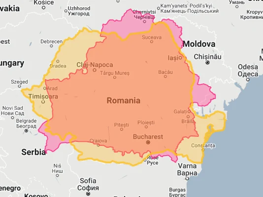
Belarus overlaid on Romania. - Belarus vs. Neighboring Countries: Belarus is approximately 63% the size of Poland (312,696 km²), 87% the size of Romania (238,397 km²), and 34% the size of Ukraine (603,550 km²). These comparisons to immediate neighbors help situate Belarus within its regional context as a medium-sized Eastern European nation.

Belarus overlaid on Poland.
Belarus’s Geographic Significance: Environmental Powerhouse
Belarus’s moderate dimensions belie its outsized environmental importance:
Forest Guardian
Despite occupying just 2.1% of Europe’s land area, Belarus contains approximately 40% of the continent’s remaining primeval forest. The Białowieża Forest (Belovezhskaya Pushcha), straddling the Poland-Belarus border, represents Europe’s largest tract of old-growth woodland – an ancient forest unchanged by human activity for over 8,000 years. Belarus protects larger portions of this UNESCO World Heritage site than any other European nation relative to its size.
Wetland Wealth
Belarus contains Europe’s largest complex of intact natural mires and wetlands in the Polesia region – often called “Europe’s Amazon.” Despite its modest territorial footprint, Belarus preserves approximately 24,000 square kilometers of wetlands – representing over 11.5% of its total area and one of the highest proportions of any country in Europe. These wetlands provide critical habitat for 52 species of mammals and 264 bird species, many rare or endangered.
Hydrological Importance
This landlocked nation contains over 20,800 rivers and 11,000 lakes, with water features covering approximately 2% of its territory. Belarus sits on the continental divide between the Baltic and Black Sea basins, with rivers from its modest territory flowing to both watersheds. Major European rivers including the Dnieper, Western Dvina, and Neman all originate from or flow through Belarus, giving this medium-sized country outsized significance in European hydrology.
Carbon Reservoir
Belarus contains some of Europe’s most significant carbon sinks within its borders. The country’s extensive peatlands, covering approximately 14.2% of its territory (the fourth-highest percentage globally), store an estimated 4 billion tons of carbon – equivalent to about 4 years of EU carbon emissions. This gives Belarus disproportionate importance in regional climate regulation despite its moderate size, with these peatlands serving as crucial carbon reservoirs.
Belarus’s Geographic Features: Flat Terrain with Environmental Richness
Belarus packs diverse natural features into its modest territory:
- Predominant Flatness: Despite common misconceptions, Belarus is predominantly flat, with 70% of its territory lying less than 200 meters above sea level. The average elevation is just 160 meters (525 feet), with the highest point – Dzyarzhynskaya Hara in the Minsk Upland – reaching a modest 345 meters (1,132 feet). This makes Belarus one of Europe’s flattest countries, with a maximum elevation difference of just 346 meters across its entire 207,600 km² territory – less elevation change than found in many European cities.
- Extensive Forests: Forests cover 39.8% of Belarus (about 8.3 million hectares) – the fifth-highest percentage in Europe and twice the European average of 19.5%. This high forest coverage within a relatively compact area creates one of Europe’s most densely wooded countries. Belarusian forests are predominantly coniferous (60%) and deciduous (40%), creating habitats for the continent’s largest populations of European bison, lynx, and wolves within a country smaller than the UK.
- Wetland Networks: Approximately 11.5% of Belarus consists of wetlands (about 24,000 km²), giving it the fourth-highest concentration of peatlands globally relative to its size. The massive Pripyat Marshes in southern Belarus form Europe’s largest wetland complex, covering over 2 million hectares – nearly 10% of Belarus’s territory. These wetlands are so extensive that they significantly influence the country’s local climate and hydrology despite Belarus’s modest overall dimensions.
- Glacial Heritage: Belarus’s entire territory was shaped by glaciation during the last ice age, creating a distinctive landscape of terminal moraines, drumlins, kames, and over 11,000 lakes – most of glacial origin. The glacial Lake Narach (79.6 km²) is Belarus’s largest, while the country’s network of post-glacial features includes over 150 erratic boulders designated as national monuments. This glacial landscape has created what geologists call a “lake district” covering approximately 3% of Belarus’s northern territory.
- River Networks: Despite being landlocked, Belarus contains over 20,800 rivers with a combined length exceeding 90,600 kilometers – creating a river density of approximately 0.44 km of river per square kilometer of territory. The largest river, the Dnieper, flows south for 700 kilometers through Belarus before continuing to Ukraine and the Black Sea. Together with the Western Dvina, Neman, Pripyat, and Bug rivers, these waterways drain 100% of Belarus’s territory to either the Baltic or Black Sea.
Belarus’s Regions: Administrative Geography
Belarus’s territory is divided into six provinces (voblasts) plus the capital city Minsk:
| Belarusian Region | Area (km²) | Comparable To | Major City |
|---|---|---|---|
| Gomel (largest voblast) |
40,372 | Slightly larger than Switzerland (41,285 km²) | Gomel |
| Vitebsk | 40,051 | Similar to Switzerland (41,285 km²) | Vitebsk |
| Minsk | 39,912 | Similar to Bhutan (38,394 km²) | Minsk |
| Mogilev | 29,068 | Similar to Albania (28,748 km²) | Mogilev |
| Brest | 32,791 | Similar to Moldova (33,846 km²) | Brest |
| Grodno (smallest voblast) |
25,127 | Similar to Macedonia (25,713 km²) | Grodno |
| Minsk City (capital administrative unit) |
348 | Similar to Malta (316 km²) | Minsk |
Population Distribution: Sparse Habitation
Belarus’s 9.4 million inhabitants are distributed across its territory with distinctive patterns:
- With approximately 9.4 million residents, Belarus maintains a relatively low population density of 45 people per square kilometer (117 per square mile) – far below neighboring Poland (122/km²) and less than 1/6th that of the similarly-sized United Kingdom (281/km²).
- Belarus shows dramatic population concentration, with nearly 20% of the entire country’s population (about 2 million people) living in the capital city of Minsk alone. This creates an extraordinary capital-to-country ratio that ranks among the highest in Europe, with Minsk having nearly 11 times more residents than the second-largest city, Gomel (510,000).
- The country exhibits a classic primate city distribution pattern, with no second-tier cities between 500,000-1,000,000 residents. Just five cities exceed 200,000 residents: Minsk, Gomel, Mogilev, Vitebsk, and Grodno. This creates a stark urban hierarchy with the capital vastly outweighing all regional centers combined.
- Belarus has experienced significant rural depopulation, with the rural population declining from 45% in 1989 to just 21% today. This rural exodus has created a population distribution anomaly – approximately 78% of Belarusians live in urban areas despite the country having extensive forests and relatively few major industrial centers.
- The country’s southern Gomel region, despite covering nearly 20% of Belarus’s territory, has experienced significant population decline following the 1986 Chernobyl nuclear disaster. The Chernobyl Exclusion Zone extends approximately 2,600 km² into Belarus – larger than Luxembourg – creating Europe’s largest permanently evacuated territory within a country already dealing with population decline.
Natural Resources: Hidden Wealth in Limited Territory
Belarus’s modest territory contains significant resources:
- Potash Dominance: Despite its relatively small size, Belarus possesses approximately 10% of the world’s potash reserves – an essential fertilizer component. The Starobin deposit in central Belarus is one of the world’s largest, containing more than 2.2 billion tons of potassium salts. This concentration makes Belarus the world’s third-largest potash producer from a territorial base smaller than Kansas.
- Timber Resources: Belarus’s 9.6 million hectares of forest (39.8% of its territory) contain approximately 1.8 billion cubic meters of standing timber. This forest wealth makes Belarus the fifth most forested country in Europe both in absolute terms and by percentage, despite having just the twelfth largest territory. These forest resources substantially exceed those of the larger and more populous Poland.
- Peat Deposits: Belarus contains Europe’s third-largest peat reserves (after Russia and Finland) at approximately 4 billion tons. These deposits, covering 14.2% of the national territory (2.6 million hectares), represent one of the world’s highest concentrations of peat per square kilometer. Belarus has historically used these deposits for fuel and soil improvement, with peat still contributing to the national energy mix.
- Oil and Natural Gas: Belarus contains modest but significant hydrocarbon reserves, with proven oil reserves of about 198 million barrels and natural gas reserves of approximately 2.8 billion cubic meters – smaller than many energy exporters but substantial for a country of Belarus’s limited size. The Pripyat Basin in the south contains most of these deposits.
- Non-metallic Minerals: Belarus’s territory contains Europe’s largest deposits of rock and potassium salts, significant reserves of construction materials (including over 300 deposits of building sand, 150 clay deposits, and extensive gravel resources), and economically important deposits of dolomite, chalk, and marl used in construction and manufacturing.
Strategic Position: The East-West Corridor
Belarus’s location gives it distinctive geopolitical significance:
- Critical Transport Corridor: Despite its modest size, Belarus sits astride the most direct land route between Central Europe and Russia. This position places approximately 80% of land-based trade between the EU and Russia across Belarusian territory. The country contains crucial segments of both the E30 highway and the main railway line connecting Berlin to Moscow – infrastructure carrying over $100 billion in trade annually through a country smaller than Kansas.
- Energy Transit Hub: Belarus hosts critical energy infrastructure, including the Druzhba (Friendship) oil pipeline – Europe’s longest oil pipeline – and the Yamal-Europe natural gas pipeline. Together, these systems carried up to 20% of Europe’s Russian gas imports and significant oil volumes prior to recent geopolitical shifts. This energy transit role gives Belarus outsized strategic importance relative to its physical dimensions.
- Cultural Borderland: Belarus occupies a distinctive cultural transition zone between Eastern and Western cultural influences, Orthodox and Catholic religious traditions, and Cyrillic and Latin alphabets. This creates a unique cultural synthesis within a relatively compact national territory that has historically functioned as a meeting ground between different European cultural spheres.
- Military Buffer Zone: Belarus’s position creates a strategic ‘cushion’ between NATO and Russia, with the country effectively forming a 650-kilometer (400-mile) buffer along a potentially sensitive frontier. Despite its modest size, Belarus hosts significant Russian military installations, including the Hantsavichy radar station and elements of Russia’s air defense network that extend Moscow’s strategic depth westward.
- Geopolitical Pressure Point: Belarus’s location creates a distinctive territorial feature known as the “Suwalki Gap” – a narrow 65-kilometer (40-mile) corridor along the Poland-Lithuania border that represents NATO’s only land connection to its Baltic members. Belarus’s position adjacent to this strategic chokepoint gives it significance in European security architecture disproportionate to its territorial dimensions.
Environmental Challenges: Pollution Legacy and Climate Impacts
Belarus’s territory faces distinctive environmental pressures:
- Chernobyl Contamination: Approximately 23% of Belarus’s territory (47,500 km²) – an area larger than Denmark – received significant radioactive contamination following the 1986 Chernobyl nuclear disaster. Despite occupying just 2.1% of Europe’s land area, Belarus absorbed approximately 70% of Chernobyl’s fallout, creating Europe’s largest zone of nuclear contamination. This disproportionate impact continues to affect land use and public health in southern Belarus.
- Water Management Challenges: Belarus’s flat topography and extensive wetlands create particular challenges for water management, with about 19% of the country’s territory historically prone to flooding. Climate change has increased precipitation variability, with more intense rainfall events affecting a landscape that naturally drains slowly due to minimal elevation differences.
- Peatland Degradation: Approximately 51% of Belarus’s extensive peatlands have been drained for agriculture, forestry, or peat extraction. This widespread modification of wetlands that naturally covered 14.2% of the national territory has reduced carbon sequestration capacity and increased fire risk, particularly during drought periods. Peatland fires in drought years can affect up to 1% of national territory.
- Industrial Pollution Legacy: Despite its relatively modest industrial base, Belarus contains several significant pollution hotspots related to Soviet-era industrial development. The cities of Novopolotsk (petrochemicals), Grodno (chemicals), and Soligorsk (potash mining) have pollution footprints that affect approximately 5% of national territory through soil and water contamination.
- Climate Change Vulnerability: Belarus’s extensive forests and wetlands face particular vulnerability to climate change, with shifting precipitation patterns and rising temperatures affecting ecosystem stability. The country has experienced increasingly frequent forest fires, with the area burned annually increasing approximately 43% since the 1990s. Climate models predict potential biome shifts affecting up to 40% of Belarus’s territory by 2070.
Border Significance: Multi-Vector Boundaries
Belarus’s borders create distinctive international connections:
- Belarus shares a 3,642-kilometer (2,263-mile) land border with five countries: Russia (1,283 km), Ukraine (1,084 km), Poland (398 km), Lithuania (679 km), and Latvia (198 km). This creates one of Eastern Europe’s most internationally connected countries relative to its size, with 1.75 kilometers of international border per 100 square kilometers of territory – more than twice Russia’s ratio.
- The country’s western border with Poland and Lithuania forms part of the European Union’s external frontier, creating what’s often called the EU’s Eastern Border. This 1,077-kilometer segment represents both a significant customs barrier and the eastern edge of the Schengen Area – Europe’s passport-free travel zone – giving Belarus disproportionate significance in European border management.
- Belarus’s eastern border with Russia is largely administrative rather than restrictive, functioning under the Union State agreement that permits free movement of people between the two countries. This creates a distinctive border asymmetry, with Belarus maintaining highly controlled western borders but essentially open eastern boundaries – a geopolitical reflection of the country’s position between two different regional systems.
- The country’s southern border with Ukraine runs through the heart of Polesia – Europe’s largest wetland region, often called “Europe’s Amazon.” This creates a natural boundary covering approximately 500 kilometers that includes the Chernobyl Exclusion Zone on both sides – a unique transboundary protected area inadvertently created by nuclear contamination.
- Belarus is completely landlocked, with the nearest coastline being the Baltic Sea approximately 160 kilometers from its northwestern border. This geographic constraint means Belarus relies on transit through neighboring countries for maritime trade, with access to seaports in Lithuania (Klaipėda), Latvia (Riga), Ukraine (Odessa), and Russia (St. Petersburg) playing crucial roles in the national economy.
Explore More Size Comparisons
Curious about how other major countries and regions compare in true size? Check out these related articles:
- Real Size Of United Kingdom: 94 Times Smaller Than Australia Yet Controls 6th Largest Economy
- Real Size Of Poland: Almost Identical To UK But With Just 1/3 The Population
- Real Size Of Ukraine: Eastern Europe’s Largest Country
- Real Size Of Lithuania: Baltic Nation’s Actual Proportions
- Complete List of Countries by True Size
Sources & Further Reading
- National Statistical Committee of Belarus. (2024). Geographical Information and National Statistics.
- Belarusian Geographic Society. (2023). Physical Geography of Belarus.
- Ministry of Natural Resources and Environmental Protection. (2024). Environmental Data of Belarus.
- CIA World Factbook. (2024). Belarus.