Mozambique
World Rank: #30
799,380 km²


Mozambique: The Enormous East African Coastal Giant Hidden in Plain Sight
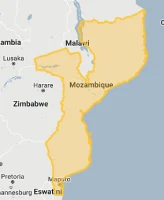
Mozambique ranks as the thirtieth largest country in the world with a territory of 799,380 square kilometers (308,642 square miles). This vast East African nation is the continent’s sixteenth-largest country, yet its true scale remains dramatically underappreciated in global consciousness. What’s truly astonishing is that Mozambique’s massive expanse could contain Turkey and Italy combined—essentially engulfing two significant Eurasian and Mediterranean powers with room to spare.
What makes Mozambique’s geography particularly remarkable is its extraordinary length. Stretching approximately 2,470 kilometers (1,535 miles) along Africa’s eastern coast, Mozambique possesses one of the continent’s longest coastlines, facing the Indian Ocean with pristine beaches, coral reefs, and tropical islands. This elongated shape creates a country of remarkable diversity, from coastal lowlands to interior plateaus and mountain ranges.
Located between approximately 10° and 27° South latitude, Mozambique experiences moderate distortion on standard Mercator projection maps. While this distortion is not as extreme as for countries at higher latitudes, the psychological tendency to underestimate African countries’ dimensions has contributed to widespread misconceptions about Mozambique’s true size and geographic significance.
Watch Mozambique shrink to its actual size as we move it toward the equator. We compare it to the USA, Europe, Africa, Greenland, Brazil, Australia, Russia, India, China, etc. You can use this country size comparison interactive map here.
Mozambique’s True Size Will Astound You: Global Perspective
To truly grasp Mozambique’s dimensions, these direct comparisons with familiar countries and regions provide eye-opening context:
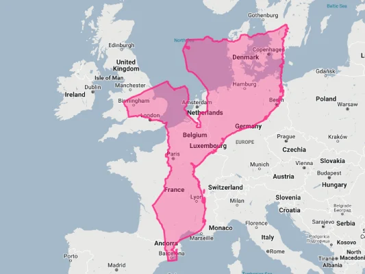
Mozambique vs. Western Europe: Mozambique would completely engulf several major European powers combined
| Comparison | Area (km²) | Size Relative to Mozambique |
|---|---|---|
| Mozambique | 799,380 | 1.0 |
| Turkey and Italy combined | ~784,000 | ~0.98 times Mozambique’s size |
| Turkey | 783,562 | 0.98 times Mozambique’s size |
| Texas and South Carolina combined (US states) | ~775,000 | ~0.97 times Mozambique’s size |
| United Kingdom, Italy, and Portugal combined | ~784,000 | ~0.98 times Mozambique’s size |
5 Jaw-Dropping Mozambique Size Comparisons You Won’t Believe
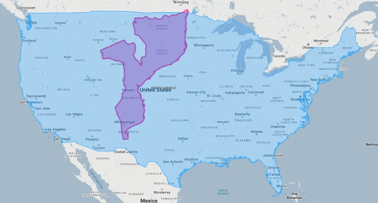
- Mozambique vs. United States: Mozambique is approximately 1.3 times the size of Texas. If placed over the eastern United States, it would stretch from New York to Georgia and west to Tennessee.
- Mozambique vs. Western Europe: Mozambique could contain Germany, Italy, Switzerland, Belgium, and the Netherlands combined.
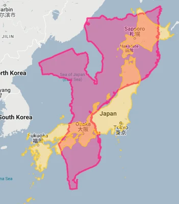
- Mozambique vs. Japan: Mozambique is approximately 2.1 times larger than Japan, despite Japan having a population over five times greater.
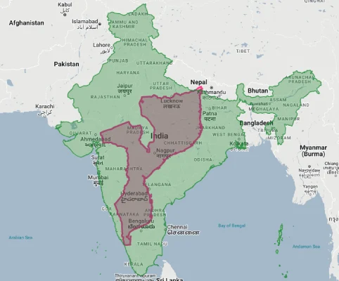
- Mozambique vs. India:
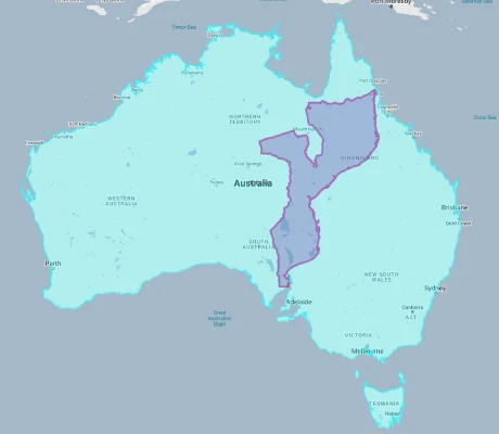
- Mozambique vs. Australia:
Mozambique’s Geographic Diversity: Three Major Zones
Mozambique’s territory can be divided into three distinct geographical regions:
- Coastal Lowlands: A broad, low-lying coastal plain extends along most of Mozambique’s 2,470-kilometer (1,535-mile) Indian Ocean coastline, varying in width from 50 to 200 kilometers (31 to 124 miles)
- Central Plateau: Moving inland, the landscape rises to form a plateau ranging from 200 to 600 meters (650 to 2,000 feet) in elevation, which covers much of central Mozambique
- Highland Regions: The western and northwestern portions of the country feature more rugged terrain with mountains and highlands, particularly along the borders with Zimbabwe, Zambia, and Malawi
- Major Rivers: Several significant rivers flow through Mozambique from the interior highlands to the Indian Ocean, including the Zambezi (Africa’s fourth-longest river), Limpopo, Save, and Rovuma
- Islands: The coastline includes numerous islands, with the Quirimbas and Bazaruto archipelagos being the largest and most significant
The Zambezi River: Dividing the Nation
The mighty Zambezi River forms a defining feature of Mozambique’s geography:
- Africa’s fourth-largest river flows through Mozambique for approximately 650 kilometers (400 miles) before emptying into the Indian Ocean
- The Zambezi effectively divides Mozambique into northern and southern halves, creating a significant transportation barrier
- The river’s massive delta covers approximately 12,000 square kilometers (4,630 square miles) of wetlands, mangrove forests, and shifting channels
- The Cahora Bassa Dam on the Zambezi, one of Africa’s largest hydroelectric facilities, created a reservoir extending 250 kilometers (155 miles) upstream with a surface area of 2,700 square kilometers (1,040 square miles)
- The river is prone to devastating floods, with major events in 2000 and 2007 displacing hundreds of thousands of people
Mount Binga: The Mozambican Highpoint
Mozambique’s western highlands contain the country’s highest elevations:
- Mount Binga, standing at 2,436 meters (7,992 feet), is Mozambique’s highest peak, located on the border with Zimbabwe in Manica Province
- The mountain is part of the Chimanimani Mountains, a range that straddles the Mozambique-Zimbabwe border
- This highland region features dramatic landscapes including sheer quartzite cliffs, montane grasslands, and patches of afromontane forest
- The area around Mount Binga is protected as part of the Chimanimani National Reserve, an important biodiversity hotspot with high levels of plant endemism
- The cooler climate of these highlands supports distinct ecosystems not found elsewhere in Mozambique, including cloud forests and alpine meadows
The Bazaruto Archipelago: Indian Ocean Paradise
Off Mozambique’s central coast lies one of Africa’s most stunning island groups:
- The Bazaruto Archipelago consists of six main islands: Bazaruto, Benguerra, Magaruque, Santa Carolina (Paradise Island), Bangue, and Pansy Shell Island
- These islands formed approximately 10,000 years ago when sea levels rose, separating coastal sand dunes from the mainland
- The archipelago is protected as Bazaruto National Park, covering 1,430 square kilometers (550 square miles) of islands and surrounding marine areas
- The islands host remarkable biodiversity, including the largest population of the rare dugong in the Western Indian Ocean, nesting sea turtles, and over 2,000 fish species
- Bazaruto’s massive sand dunes, some reaching 100 meters (330 feet) in height, create dramatic landscapes shifting between brilliant white beaches, azure waters, and inland freshwater lakes
Population Distribution: A Coastal Nation
Mozambique’s population pattern shows interesting demographic trends:
- With approximately 33 million people, Mozambique has a moderate average population density of about 41 people per square kilometer
- This density varies dramatically by region, with about 60% of Mozambicans living within 50 kilometers (31 miles) of the coast
- About 38% of Mozambicans live in urban areas, with urbanization accelerating
- Maputo, the capital and largest city with about 1.1 million inhabitants (and 2.5 million in the greater metropolitan area), is located at the country’s southernmost point
- Population distribution is also influenced by major transportation corridors—the “development corridors” that connect coastal ports to neighboring landlocked countries
Mozambique’s Provinces: Large as European Nations
Many of Mozambique’s 11 provinces (administrative divisions) are comparable in size to entire countries:
| Mozambican Province | Area (km²) | Comparable Country |
|---|---|---|
| Niassa | 129,056 | Greece (131,957 km²) |
| Cabo Delgado | 82,625 | Austria (83,871 km²) |
| Nampula | 81,606 | Czech Republic (78,865 km²) |
| Zambézia | 103,478 | Iceland (103,000 km²) |
| Tete | 100,724 | South Korea (100,210 km²) |
Geography and Climate: Tropical Variations
Mozambique’s geography creates a predominantly tropical climate with regional variations:
- Located entirely within the tropics, Mozambique has a climate heavily influenced by the warm Mozambique Current flowing southward along its coast and the inland plateau elevations
- The country experiences two distinct seasons: a wet season from November to April and a dry season from May to October
- Annual rainfall varies significantly from north to south, with the northern provinces receiving up to 1,500 mm (59 inches) while the southern regions may get less than 600 mm (24 inches)
- Coastal areas experience higher humidity and more moderate temperatures, while inland regions have greater temperature ranges
- Mozambique is vulnerable to tropical cyclones during the summer months (November to April), with devastating examples including Cyclone Idai in 2019, which affected millions of people
Natural Resources: Untapped Potential
Mozambique possesses significant natural resources:
- In 2010-2011, massive natural gas discoveries were made offshore in the Rovuma Basin, with reserves estimated at 100 trillion cubic feet—among the largest in Africa
- The country has substantial mineral deposits, including coal, titanium, tantalum, graphite, gold, precious stones, and bauxite
- Mozambique’s extensive coastline provides rich marine resources, though these are under pressure from overfishing
- The country has considerable hydroelectric potential, primarily from the Zambezi River, with the Cahora Bassa Dam generating 2,075 megawatts of power
- About 49% of Mozambique is forested, with valuable hardwoods including ebony, mahogany, and ironwood, though deforestation is a significant concern
Biodiversity: Rich but Threatened
Mozambique’s diverse ecosystems support remarkable biodiversity:
- The country hosts approximately 6,000 plant species, 740 bird species, 214 mammal species, and 171 reptile species
- Major ecosystems include coastal forests, miombo woodlands, mopane woodlands, montane forests, grasslands, mangroves, and marine systems
- Mozambique contains several biodiversity hotspots, including the Eastern Afromontane zone in the highlands and the Coastal Forests of Eastern Africa along parts of the coast
- Iconic wildlife includes elephants, lions, leopards, hippos, crocodiles, and a variety of antelope species, though many populations were reduced during the civil war (1977-1992)
- Marine biodiversity is particularly rich, with coral reefs, seagrass beds, and mangrove forests supporting dugongs, five species of sea turtles, hundreds of coral species, and over 2,000 fish species
Gorongosa National Park: Resurrection of a Wilderness
Central Mozambique contains one of Africa’s most remarkable conservation success stories:
- Gorongosa National Park covers approximately 4,000 square kilometers (1,544 square miles) at the southern end of the Great African Rift Valley
- The park encompasses extraordinary ecological diversity, from floodplains and savanna to woodland and rainforest on Mount Gorongosa
- Once one of Africa’s most spectacular wildlife reserves, Gorongosa lost 95% of its large animals during Mozambique’s civil war (1977-1992)
- Since 2004, an ambitious restoration project has revitalized the ecosystem, with wildlife populations rebounding dramatically—a globally significant conservation success story
- Today, the park again supports thriving populations of elephants, lions, buffalo, hippos, and numerous antelope species, while serving as a model for combining conservation with community development
Geographic Challenges: Cyclones, Floods, and Development
Mozambique’s geography creates significant development challenges:
- Natural Disasters: Mozambique is highly vulnerable to cyclones, floods, and droughts, with climate change increasing the frequency and intensity of extreme weather events
- Transportation: The country’s elongated shape creates challenges for national integration, with the Zambezi River dividing the country and few bridges crossing this major barrier
- Regional Inequality: Development is concentrated in the southern region around Maputo, creating significant regional disparities
- Coastal Erosion: Rising sea levels and coastal erosion threaten low-lying coastal areas where much of the population lives
- Deforestation: Forest loss continues at concerning rates, driven by charcoal production, agriculture, and timber harvesting
Explore More Size Comparisons
Curious about how other major countries and continents compare in true size? Check out these related articles:
- The Hidden Enormity of Namibia: Desert Giant Larger Than France and the United Kingdom Combined
- The Surprising Scale of Turkey: Transcontinental Power Larger Than Most European Nations Combined
- The Astonishing Scale of Pakistan: Asian Giant Larger Than Turkey and United Kingdom Combined
- The True Size of Africa: A Continent Far Larger Than Maps Suggest
- Complete List of Countries by True Size
Sources & Further Reading
- CIA World Factbook. (2023). Mozambique.