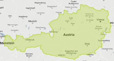
Austria
World Rank: #115
83,871 km² (32,383 sq mi)
Next Larger Country
(Rank #114)
United Arab Emirates
83,600 km² (32,278 sq mi)
Austria: The Alpine Nation That’s Much Smaller Than You Think
Did you know Austria is smaller than Maine yet contains the largest underground lake in Europe? Or that this Alpine nation has more castles per square kilometer than any other European country?
Welcome to the surprising dimensions of Austria – a country whose historical significance and natural grandeur belie its modest size. Ranking 115th globally with just 83,871 square kilometers (32,383 square miles), Austria is smaller than the U.S. state of Maine (91,646 km²) and occupies just 35% the territory of neighboring Germany despite once ruling a vast empire that dominated Central Europe.
In this article, we’ll drag Austria across the map to reveal how this landlocked nation truly measures up against other countries. Located between 46.4°N and 49.0°N latitude, Austria experiences minimal map distortion on standard projections, meaning its represented size is quite accurate – a compact, roughly rectangular country nestled in the heart of Europe, sharing borders with eight different nations.
Despite its limited dimensions, Austria packs extraordinary geographic diversity into its territory. The country transitions from Alpine peaks exceeding 3,798 meters (12,461 feet) to gentle lowlands and river valleys below 200 meters (656 feet), creating remarkable topographic variety within a nation that’s just 580 kilometers (360 miles) across at its widest point. Most impressively, this modestly-sized country contains over 900 peaks above 3,000 meters (9,842 feet) – one of Europe’s highest concentrations of alpine summits.
World maps fall victim to Mercator projection distortion (Africa is much bigger than on the map, Greenland is much smaller, etc.). Here is the true size of Austria compared to other big countries (adjusting for Mercator projection distortion):
Watch how Austria compares when overlaid on other countries. We’ve moved it across the USA, UK, Russia, and many other nations to reveal its true proportions. You can use this country size comparison interactive map here.
7 Mind-Blowing Austria Size Facts
- Austria is smaller than Maine (83,871 km² vs. 91,646 km²)
- The country is just 35% the size of Germany yet shares the same language and cultural heritage
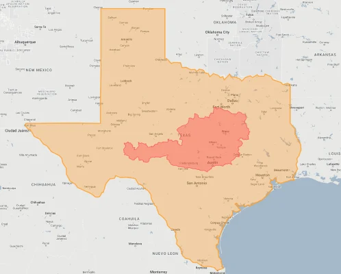
- Austria fits inside Texas more than 8 times
- Despite its small size, Austria contains over 13,000 castles, palaces, and stately homes
- Austria is 204 times smaller than Russia yet once led an empire of 52 million people
- You can drive across Austria’s entire width in just 7 hours (580 km/360 miles)
- Austria contains 900+ mountain peaks above 3,000 meters (9,842 feet) despite being smaller than South Carolina
Austria’s True Size in Global Perspective
To appreciate Austria’s actual dimensions, these direct comparisons with familiar regions offer eye-opening context:
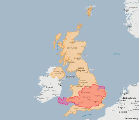
Austria vs. United Kingdom: Austria is approximately 35% the size of the UK (83,871 km² vs. 242,495 km²)
| Comparison | Flag | Area (km²) | Size Relative to Austria |
|---|---|---|---|
| Austria | |
83,871 | 1.0 |
| Maine (US state) |  |
91,646 | 1.09 times Austria’s size |
| South Carolina (US state) | |
82,931 | 0.99 times Austria’s size |
| Czech Republic |  |
78,867 | 0.94 times Austria’s size |
| United Arab Emirates | |
83,600 | 0.99 times Austria’s size |
| Scotland (UK constituent country) |  |
77,933 | 0.93 times Austria’s size |
| Bavaria (German state) | 70,550 | 0.84 times Austria’s size |
5 Surprising Austria Size Comparisons
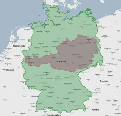
- Austria vs. Germany: Austria (83,871 km²) is just 35% the size of Germany (357,022 km²) despite the two nations sharing language, culture, and a complex intertwined history. This contrast is particularly striking considering that Austria once dominated German affairs through the Habsburg Empire – a case of a smaller nation wielding influence over its much larger neighbor. Modern Germany could contain nearly 4.3 Austrias within its borders, yet Austria maintains a distinct national identity and similar economic development.
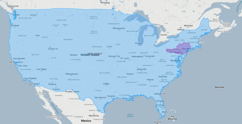
- Austria vs. United States: Austria would fit into the continental United States approximately 110 times, dramatically illustrating the difference in scale between European and North American geography. Austria is smaller than 38 of the 50 U.S. states, with its closest size equivalents being South Carolina (82,931 km²) and Maine (91,646 km²). If placed over the eastern United States, Austria would cover roughly the distance from New York City to Washington D.C. – underscoring how a European nation with substantial global impact occupies territory Americans might consider merely regional.
- Austria vs. Former Empire: Perhaps the most striking size comparison involves Austria’s historical empire. Prior to World War I, the Austro-Hungarian Empire covered approximately 676,615 square kilometers (261,243 square miles) – more than 8 times larger than modern Austria. This creates one of Europe’s most dramatic contrasts between imperial and current territory, with modern Austria occupying just 12.4% of its former imperial lands. The successor states to this empire now include portions of 13 modern countries across Central and Eastern Europe.

Austria overlaid on Hungary. - Austria vs. Texas: Austria (83,871 km²) would fit into Texas (695,662 km²) more than 8 times, highlighting how a single U.S. state dwarfs a European nation that once dominated Central European politics. This comparison is particularly striking considering Austria’s outsized historical and cultural influence compared to its modest dimensions – Vienna alone produced intellectual and artistic contributions disproportionate to the country’s size.
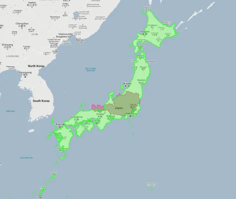
Austria overlaid on Texas. - Austria vs. Japan: Austria is approximately 22% the size of Japan (377,975 km²), though both nations share distinctive mountainous topography and limited arable land. This comparison highlights how countries with similar geographic challenges can develop along different paths due to location and historical circumstances. Despite occupying less than a quarter of Japan’s territory, Austria maintains comparable GDP per capita and quality of life measurements.
Austria’s Unique Geographic Position: The Continental Crossroads
Austria’s location gives it distinctive geographical significance despite its modest size:
The Eight-Neighbor Nation
Despite its modest dimensions, Austria shares borders with eight different countries: Germany, Czech Republic, Slovakia, Hungary, Slovenia, Italy, Switzerland, and Liechtenstein. This creates one of the world’s highest neighbor-to-area ratios at approximately 0.95 neighbors per 10,000 square kilometers – more than triple Germany’s ratio of 0.28. This exceptional connectivity has historically positioned Austria as a crucial crossroads between Central, Eastern, Southern, and Western Europe, with Vienna functioning as a continental hub despite the country’s limited territorial footprint.
The Alpine Keystone
Austria occupies a central position within the Alpine arc, containing approximately 28% of the entire Alpine territory despite representing just 4% of the total area of Alpine nations. The country serves as a crucial east-west connector through the Alps via the strategically vital Brenner Pass and other mountain corridors. This Alpine centrality has given Austria disproportionate control over trans-European trade routes and transportation links through history, with mountain passes through Austrian territory functioning as continental gateways between Northern and Southern Europe.
The Danube Linchpin
The Danube River flows through Austria for 350 kilometers (217 miles), representing approximately 13% of the country’s territory but creating outsized hydrological significance. Austria occupies a crucial middle position along Europe’s second-longest river, effectively controlling Danube navigation between Upper and Lower sections. This riverine position has historically given Austria exceptional influence over Continental trade, with Vienna’s development as a major European capital largely stemming from its control of this vital waterway despite Austria’s modest overall territorial dimensions.
The Cultural Bridge
Austria’s position at the intersection of Germanic, Slavic, Hungarian, and Italian cultural spheres has created a distinctive role as a cultural crossroads disproportionate to its size. The country functions as a transitional zone between major European cultural regions, with significant historical connections to Western, Eastern, and Southern European traditions. This bridging position allowed Vienna to develop as a continental cultural capital despite Austria’s limited territory, producing contributions to music, art, psychology, and philosophy vastly exceeding what would be expected from a nation of Austria’s modest dimensions.
Austria’s Alpine Character: Vertical Dimension Compensates for Limited Area
Austria’s mountainous terrain creates extraordinary geographic diversity within limited borders:
- Predominantly Mountainous: Approximately 68% of Austria’s territory consists of mountains, primarily the Eastern Alps but also including portions of the Central Alps and the beginning of the Carpathian range. This mountainous character creates remarkable vertical diversity within limited horizontal space, with elevations ranging from 114 meters (374 feet) along the Danube in Vienna to 3,798 meters (12,461 feet) at Grossglockner – Austria’s highest peak. The Eastern Alps alone contain over 900 peaks exceeding 3,000 meters (9,842 feet) within Austrian territory – an extraordinary concentration for a country smaller than Maine.
- Valley Networks: Austria’s mountain terrain is interspersed with approximately 200 significant valleys forming distinctive settled regions called “täler” (singular: tal). These valleys create naturally compartmentalized regions within Austria’s already limited territory, with the Inn Valley, Salzach Valley, Drau Valley, and Mur Valley functioning as distinct geographical and cultural units. This valley-dominated landscape creates a situation where direct distances between major Austrian cities often belie the actual travel routes, with many journeys requiring navigation around mountain barriers despite the country’s modest dimensions.
- Glacial Features: Despite its small size, Austria contains 925 glaciers covering approximately 450 square kilometers – 0.5% of the national territory. These include the Pasterze Glacier (8.4 km/5.2 miles long), the largest glacier in the Eastern Alps. Austria’s glacial resources store approximately 17-22 billion cubic meters of freshwater – creating one of Europe’s most important water towers within limited territorial space. The country’s glaciers and high alpine regions create environmentally significant cold-water sources for major European rivers including the Danube, Rhine, and their tributaries.
- Cave Networks: Austria contains more than 18,000 documented caves within its modest territory, including some of Europe’s most significant underground systems. Most remarkably, the Seegrotte near Vienna contains Europe’s largest underground lake at 6,200 square meters – an extraordinary subterranean feature in a country smaller than South Carolina. The Eisriesenwelt near Salzburg, with 42 kilometers (26 miles) of passages, ranks as the world’s largest ice cave, while the Dachstein-Mammuthöhle system extends for more than 67 kilometers (42 miles) – both contained within Austria’s limited borders.
- Biogeographic Diversity: Austria’s complex topography creates exceptional environmental diversity within limited territory. The country encompasses six distinct biogeographic regions: Alpine, Continental, Pannonian, Carpathian, Baltic, and Mediterranean Illyrian – an extraordinary ecological range for a country of Austria’s size. This environmental diversity has produced remarkable biodiversity, with Austria containing approximately 45,000 documented animal species and 3,165 plant species – roughly 30% of all Central European flora concentrated in just 83,871 square kilometers.
Austria’s Regions: Administrative Geography
Austria is divided into nine federal states (Bundesländer):
| Austrian State | Area (km²) | Comparable To | Capital |
|---|---|---|---|
| Lower Austria (largest state) |
19,178 | Slightly smaller than Israel (20,770 km²) | St. Pölten |
| Styria | 16,401 | Similar to Kuwait (17,818 km²) | Graz |
| Upper Austria | 11,982 | Similar to Qatar (11,586 km²) | Linz |
| Tyrol | 12,640 | Slightly larger than Lebanon (10,452 km²) | Innsbruck |
| Carinthia | 9,538 | Similar to Cyprus (9,251 km²) | Klagenfurt |
| Vienna (smallest state) |
415 | Similar to Andorra (468 km²) | Vienna |
| Burgenland (easternmost state) |
3,965 | Similar to Rhode Island (4,001 km²) | Eisenstadt |
Population Distribution: Concentrated in Limited Areas
Austria’s 9.1 million inhabitants are distributed unevenly across its compact territory:
- With approximately 9.1 million residents across 83,871 square kilometers, Austria maintains a moderate population density of 109 people per square kilometer (282 per square mile) – slightly above the European average but considerably lower than neighboring countries like Switzerland (219/km²), Germany (232/km²), and Italy (200/km²).
- Austria shows dramatic population concentration, with Vienna alone containing approximately 1.9 million people – around 21% of the entire country’s population within just 0.5% of its territory. This creates a classic primate city pattern, with Vienna more than 4 times larger than Austria’s second city, Graz (approximately 295,000 residents). The Vienna metropolitan area (2.8 million) contains nearly 31% of Austria’s population in an area less than 3% of the national territory.
- Population distribution follows Austria’s complex topography, with approximately 60% of Austrians living along the country’s major river valleys – primarily the Danube, Inn, Salzach, Enns, and Mur. These valley corridors contain the country’s nine largest cities and most of its major transportation infrastructure, creating ribbon-like settlement patterns tightly constrained by mountain terrain. This hydrographic influence means that despite Austria’s compact dimensions, approximately 70% of its territory is sparsely populated.
- The country exhibits strong east-west population density gradients, with eastern Austria (primarily Lower Austria, Vienna, and northern Burgenland) containing approximately 45% of the national population within 30% of the territory. This creates population densities exceeding 120 people per square kilometer in eastern regions while western alpine states like Tyrol maintain average densities around 60 people per square kilometer despite containing most major tourism centers.
- Austria’s mountainous terrain creates vertical population distribution patterns unusual for a European country, with permanent settlements historically limited to elevations below 1,200 meters (3,937 feet). Approximately 75% of Austrians live below 500 meters elevation despite mountains covering 68% of the national territory. This vertical population distribution creates a situation where most Austrians live in relatively small habitable zones within a country that appears larger than its effective settled area.
Historical Geographic Transformation: From Empire to Small State
Austria’s territorial evolution created one of Europe’s most dramatic geographic contractions:
- Imperial Contraction: Prior to World War I, the Austro-Hungarian Empire covered approximately 676,615 square kilometers (261,243 square miles) – more than 8 times larger than modern Austria’s 83,871 square kilometers. The 1919 Treaty of Saint-Germain-en-Laye reduced Austria to just 12.4% of its former imperial territory, creating one of history’s most dramatic peaceful territorial contractions. This reduction transformed Austria from a multinational empire dominating Central Europe into a small, predominantly ethnically homogeneous Alpine republic.
- Population Transformation: The post-WWI settlement reduced Austria’s population from approximately 52 million to just 6.5 million – a decline of nearly 88%. This demographic collapse fundamentally altered Austria’s position within Europe, transforming it from one of the continent’s most populous polities to a minor state. Vienna, designed as an imperial capital for a vast multinational empire, suddenly became the oversized administrative center for a small Alpine nation, creating distinctive urban-rural imbalances that persist to the present.
- Territorial Discontinuity: The collapse of the Austro-Hungarian Empire created distinctive territorial discontinuities, with many historic Austrian regions suddenly located in different countries. This created situations where culturally and historically Austrian cities like Prague, Brno, Trieste, Zagreb, and Budapest were separated from Austria by new international boundaries – effectively severing cultural connections that had developed over centuries and fragmenting once-integrated economic regions.
- Geographic Reorientation: Austria’s imperial contraction fundamentally changed the country’s geographic orientation, transforming it from a multinational state spanning Central, Eastern, and Southeastern Europe to a predominantly Alpine nation. This shifted Austria’s self-perception from a Danubian empire to an Alpine republic, with mountains replacing rivers as the defining national geographical feature. This reorientation created a distinctive alpine national identity that distinguishes modern Austria from its imperial predecessor despite occupying part of the same territory.
- Border Creation: Modern Austria’s borders largely follow geographic features but were primarily determined by political and ethnic considerations following World War I. The country’s northern border with the Czech Republic and Slovakia approximately follows the historic boundary between Austrian and Bohemian crown lands, while its eastern border with Hungary represents a compromise that left significant Hungarian territory in Austria (Burgenland). The southern border with Slovenia and Italy cut through historically integrated regions like Tyrol and Carinthia, creating divided cultural landscapes that continue to influence regional identities.
Border Complexity: The Multi-Neighbor Nation
Austria’s boundaries create distinctive international relationships:
- Austria shares a 2,562-kilometer (1,591-mile) land border with eight countries: Germany (784 km), Czech Republic (402 km), Slovakia (105 km), Hungary (366 km), Slovenia (330 km), Italy (404 km), Switzerland (158 km), and Liechtenstein (35 km). This creates Europe’s highest ratio of neighbors to national territory at 0.95 neighbors per 10,000 square kilometers – more than triple Germany’s ratio of 0.28 and far exceeding France’s 0.15. This exceptional multinational connectivity means that the average distance from any point in Austria to an international border is just 32 kilometers (20 miles).
- The country’s distinctive elongated east-west orientation creates a maximum east-west distance of 580 kilometers (360 miles) compared to a north-south distance of just 294 kilometers (183 miles) at its widest point. This shape stretches Austria across Central Europe’s major geographic units – from the Bohemian Massif through the Eastern Alps to the Pannonian Plain – creating extraordinary environmental diversity within limited territorial dimensions and facilitating connections with disparate European regions.
- Austria maintains one of Europe’s most complex border regions in South Tyrol (Alto Adige), where the border with Italy cuts through the historically integrated Tyrol region. This creates a distinctive situation where Germanic-speaking South Tyroleans on the Italian side maintain closer cultural and historical ties to Austrian Tyrol than to most of Italy. This cross-border cultural continuity creates a transnational region spanning the international boundary, with the Brenner Pass functioning as a connector rather than divider despite the political border.
- As a landlocked country, Austria depends entirely on neighboring nations for maritime access. The nearest seaports to Vienna are Trieste, Italy (370 km/230 mi) and Koper, Slovenia (390 km/242 mi), both former Habsburg ports now in different countries. This creates distinctive transportation dependencies and has incentivized Austria to develop exceptional land-based infrastructure connecting to these Mediterranean outlets – a geopolitical compensation for the lack of direct sea access.
- Austria’s position within the Schengen Area facilitates relatively frictionless mobility across all its international borders except Liechtenstein (which maintains a customs union with Switzerland). This open-border situation effectively enlarges Austria’s functional territory, with many border regions functioning as integrated cross-border units. The Vienna-Bratislava metropolitan region forms Europe’s only significant bi-national capital region, with just 55 kilometers (34 miles) separating these cities that were united within the Habsburg Empire until 1918.
Alpine Resources: Quality Over Quantity
Austria’s modest territory contains distinctive natural assets:
- Water Wealth: Despite occupying less than 2% of Europe’s land area, Austria contains approximately 5% of the continent’s freshwater resources – an extraordinary hydrological concentration. The country’s 925 glaciers store approximately 17-22 billion cubic meters of water, while its Alpine lakes contain an additional 14 billion cubic meters. This hydrological wealth has allowed Austria to generate nearly 60% of its electricity from hydropower – one of the highest percentages worldwide – and maintain water exports to neighboring countries despite limited territorial dimensions.
- Forest Resources: Austria maintains exceptional forest cover at approximately 47% of national territory (about 39,000 square kilometers) – among Europe’s highest percentages and well above the EU average of 38%. This creates one of Europe’s highest wood volumes per capita, with Austria producing approximately 20 million cubic meters of timber annually from a territory smaller than Maine. Austria’s sustainable forestry practices have actually increased forest coverage by 300,000 hectares over the past 50 years despite limited national territory.
- Mineral Deposits: Austria’s modest territory contains significant mineral wealth, particularly in Alpine regions. The country leads Europe in magnesite production (approximately 750,000 tons annually from a single mine at Hochfilzen) and contains Europe’s largest tungsten deposit at Mittersill – providing approximately 8% of global supply from a mine covering just 15 square kilometers. Despite its limited size, Austria produces over 30 million tons of industrial minerals annually, including talc, kaolin, dolomite, and gypsum – creating substantial resource outputs from minimal territory.
- Agricultural Efficiency: Austria’s limited territory includes approximately 31,815 square kilometers of agricultural land (38% of national territory), predominantly in eastern regions. Despite territorial constraints, Austria maintains exceptional agricultural productivity, with average wheat yields of 5.8 tons per hectare compared to the European average of 5.2 – creating substantial food production capacity from limited arable land. The country produces approximately 5.2 million tons of grains, 3.7 million tons of vegetables, and 1.1 million tons of fruits annually from its modest agricultural territory.
- Recreational Resources: Austria’s mountainous terrain creates exceptional winter sports resources, with approximately 22,000 kilometers of ski runs and 3,000 ski lifts concentrated within limited territory. The country contains roughly 400 ski areas despite occupying less than 1% of Europe’s land area – creating the world’s highest density of Alpine ski resources. This topographic advantage has allowed Austria to develop approximately 150 million tourist overnight stays annually – nearly 17 visitor nights per resident per year – generating substantial economic activity from limited territorial dimensions.
Explore More Size Comparisons
Curious about how other major countries and regions compare in true size? Check out these related articles:
- Real Size Of Switzerland: Alpine Nation Smaller Than West Virginia Yet Contains 48 Mountains Over 4,000 Meters
- Real Size Of Germany: Central European Power’s True Dimensions
- Real Size Of Czech Republic: The Most Castles Per Square Kilometer In Europe
- Real Size Of Hungary: Smaller Than Indiana But With More Thermal Water Than Any Country In Europe
- Complete List of Countries by True Size
Sources & Further Reading
- Statistics Austria. (2024). Geographical Information and National Statistics.
- CIA World Factbook. (2024). Austria.