World Rank: #111
88,361 km² (34,116 sq mi)
Next Larger Country
(Rank #110)
Jordan
89,342 km² (34,495 sq mi)

Serbia: The Balkan Crossroads Packed with Surprising Geographical Extremes
Did you know Serbia, smaller than Ohio, contains Europe’s largest river gorge? Or that this compact Balkan nation could fit inside Texas 7.5 times yet houses some of the continent’s oldest archaeological sites dating back over 8,000 years?
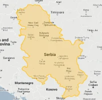
Welcome to Serbia – a geographically diverse powerhouse where the Pannonian Plains meet the Dinaric Alps in a territory just 88,361 square kilometers (34,116 square miles). This landlocked nation sits at the crossroads of Central and Southeast Europe, where major European cultural, religious, and geopolitical spheres have converged for millennia. Despite its modest size, Serbia delivers extraordinary natural diversity: from the fertile plains along the Danube (Europe’s second-longest river), through rolling hills dotted with medieval monasteries, to dramatic mountain ranges with peaks exceeding 2,000 meters.
Serbia’s strategic position at the intersection of major European corridors has placed this relatively small country at the center of continental history. The Morava-Vardar valley creates the most direct route between Central Europe and the Aegean Sea, while the Danube River connects Western Europe with the Black Sea – giving Serbia outsized geopolitical importance despite controlling less territory than Indiana.
In this exploration, we’ll drag Serbia across the global map, revealing the Mercator projection distortion (made with our interactive country comparison map tool):
Watch Serbia’s true dimensions revealed as we drag it across continents! See how this Balkan nation compares to global giants and neighboring countries using our interactive mapping tool.
7 Mind-Blowing Serbia Size Facts That Will Astonish You
- Serbia is smaller than Ohio (88,361 km² vs. 116,096 km²) yet contains more thermal springs than any other European country except Iceland
- Despite being just 1/193rd the size of Russia, Serbia’s capital Belgrade is larger than all but 15 Russian cities
- You could fit Serbia into Texas more than 7.5 times, yet it contains 15 major river systems within its compact borders
- Serbia houses Europe’s largest gorge – the Đerdap/Iron Gates on the Danube is 100 km long with cliffs rising 800 meters – all within a country smaller than Maine
- This little-known wine producer has more vineyard acreage per square kilometer than France, with some regions cultivating grapes continuously since Roman times
- You can drive across Serbia’s entire width in just 5 hours (370 km/230 miles) while passing through five distinct climate zones
- While occupying just 0.05% of the world’s land area, Serbia contains 39% of all European bird species and 18% of all European butterfly species
Serbia’s True Size in Global Perspective
Need perspective on just how modest Serbia’s territory really is? These striking comparisons reveal the surprising dimensions of this influential Balkan nation:
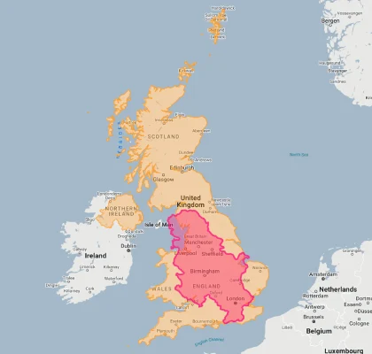
Serbia would cover just 36% of the United Kingdom’s territory, yet has more thermal springs, higher mountains, and significantly more hours of sunshine per year!
| Size Twin | Flag | Area (km²) | Size Comparison to Serbia |
|---|---|---|---|
| Serbia | |
88,361 | Our Balkan baseline! |
| Indiana (US state) |  |
94,321 | 7% larger than Serbia, though with 3 million fewer people |
| Portugal |  |
92,212 | 4% larger than Serbia despite being perceived as a much bigger country |
| Jordan | |
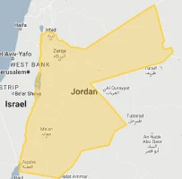
89,342 | Just 1% larger than Serbia yet has 40% less population |
| Hungary |  |
93,030 | 5% larger than Serbia but contains no mountains over 1,000 meters |
| Maine (US state) | |
91,646 | 4% larger than Serbia yet has only 1.3 million people to Serbia’s 7 million |
| Lake Superior (Great Lake) | |
82,100 | 7% smaller than Serbia – the entire country is just slightly larger than this single lake! |
5 Eye-Opening Size Comparisons That Put Serbia in Perspective
- Serbia vs. Former Yugoslavia: The Dramatic Downsizing
Perhaps the most striking size comparison for Serbia involves its own historical territory. Modern Serbia (88,361 km²) represents just 34.5% of former Yugoslavia’s 255,804 km² – a dramatic territorial contraction that transformed the country from a significant regional power to a modest Balkan state. Six independent nations now occupy the territory that once formed Yugoslavia, with Serbia reduced to a fraction of its former federal territory. This historical shrinkage represents one of Europe’s most significant territorial transformations in recent decades. While Serbia remains the largest successor state, its current borders contain just over one-third of the landscape it influenced within Yugoslavia – creating a dramatic example of how geopolitical events can fundamentally reshape a nation’s geographical footprint. Despite this territorial reduction, Serbia maintains the strongest military and largest economy among the former Yugoslav republics, demonstrating how national influence can sometimes transcend simple geographical dimensions.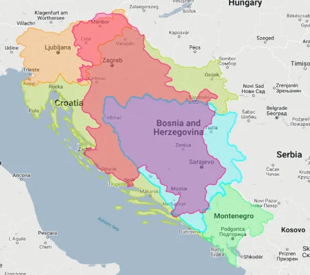
- Serbia vs. United States: A Balkan Nation Lost in America
The Serbian territory would fit into the continental United States nearly 107 times! This extreme contrast shows how a historically significant European nation occupies what Americans might consider merely a mid-sized region. Serbia is smaller than 41 of the 50 U.S. states, with its closest size equivalent being Indiana (94,321 km²). If placed over the eastern United States, Serbia would barely span the distance from Philadelphia to Richmond – yet this tiny territory contains more years of recorded history than the entire United States. The Serbian capital Belgrade has been continuously inhabited for over 7,000 years, predating America’s oldest city (St. Augustine, FL) by more than 6,650 years. Perhaps most astonishingly, Serbia’s Starčevo and Vinča archaeological cultures (5500-4500 BCE) were developing sophisticated agricultural settlements and creating proto-writing systems when most of North America remained in the hunter-gatherer stage – all within a territory that would be considered a modest region within just one U.S. state.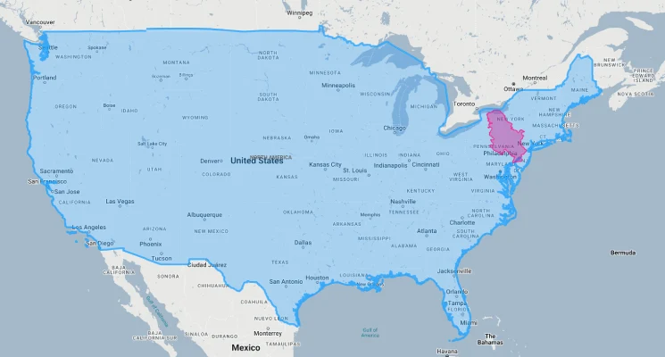
- Serbia vs. Russia: The Ultimate Size Disparity
Serbia (88,361 km²) could fit into Russia (17,098,246 km²) an astounding 193 times, creating one of the world’s most extreme size comparisons. Just Russia’s Sakha Republic alone (3,083,523 km²) could contain 34 Serbias within its borders. When overlaid on a map of Russia, Serbia appears as little more than a tiny speck – smaller than many Russian cities’ metropolitan areas. Despite this overwhelming disparity, Serbia maintains a population density approximately 23 times higher than Russia’s, with 7 million people living in a space less than 0.52% the size of Russia. Perhaps most remarkably, the Serbian capital Belgrade (1.4 million residents) is actually larger than all but 15 Russian cities despite the enormous territorial difference between the two nations. This extraordinary contrast highlights how population concentration can sometimes compensate for limited geographical dimensions, allowing a tiny nation to develop urban centers rivaling those of much larger countries.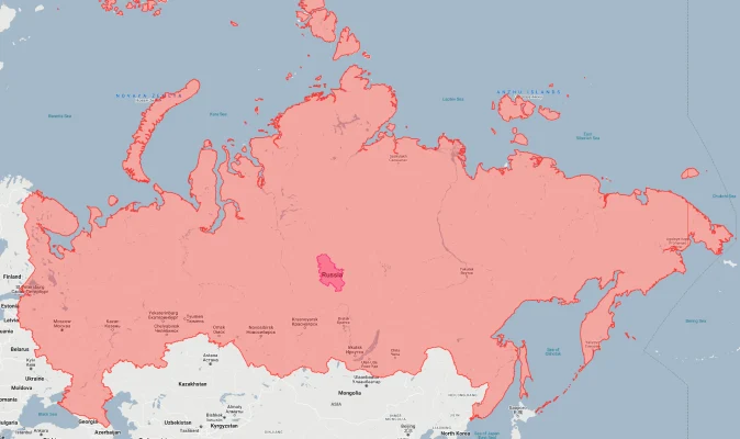
- Serbia vs. Texas: The Lone Star Swallows the Balkan State
Serbia (88,361 km²) would fit into Texas (695,662 km²) more than 7.5 times, highlighting how a single U.S. state dwarfs this historically significant European nation. The distance from El Paso to Texarkana (greater than 800 miles) is more than 2.5 times Serbia’s entire north-south length. While driving across Texas requires at least 12 hours, you can traverse Serbia from Hungary to North Macedonia in just 5 hours. What makes this comparison particularly striking is the historical context: Serbia as a named political entity has existed in various forms since the 7th century CE, developing a national identity over approximately 1,400 years, while Texas has existed as a distinct political unit (Spanish colony, Mexican state, republic, and U.S. state) for just over 300 years. This comparison dramatically illustrates how historical depth and territorial extent often have little correlation – Serbia packs millennia of cultural development and over 40 different ethnic groups into a space less than 13% the size of Texas.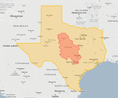
- Serbia vs. Africa: A European Minnow on an African Giant
The entire territory of Serbia (88,361 km²) represents just 0.29% of Africa’s vast landmass – you could fit it into the continent approximately 344 times! Even relatively small African nations like Uganda (241,550 km²) and Ghana (238,533 km²) are nearly three times larger than Serbia. What makes this comparison particularly meaningful is the ecological contrast: Serbia contains 39% of European bird species within its tiny territory, while much larger African nations often contain a smaller percentage of their continent’s biodiversity. This comparison also illuminates historical power dynamics – Serbia, despite its modest size, was historically able to project significant military and cultural influence across the Balkans, while many African nations with territories 3-10 times larger struggled to establish similar regional dominance due to colonial intervention. This dramatic contrast demonstrates how geopolitical influence often transcends simple territorial dimensions, with factors like historical continuity, resource concentration, and strategic location sometimes enabling very small nations to exert outsized regional importance.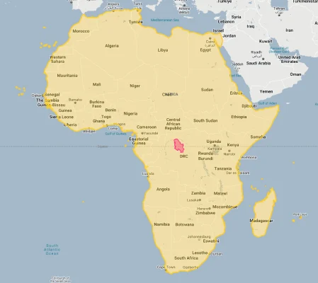
The Balkan Crossroads: Serbia’s Strategic Geographic Position
Despite its modest dimensions, Serbia occupies one of the most strategically significant positions in all of Europe:
Where Eight Nations Converge
Serbia sits at the ultimate Balkan crossroads, sharing borders with eight different countries despite its limited dimensions: Hungary to the north, Romania to the northeast, Bulgaria to the southeast, North Macedonia to the south, Kosovo (whose status remains disputed) to the southwest, Montenegro to the southwest, Bosnia and Herzegovina to the west, and Croatia to the northwest. This extraordinary border density creates one of the world’s highest neighbor-to-area ratios at approximately 0.091 neighbors per 1,000 square kilometers – nearly triple the European average of 0.032. This exceptional connectivity has positioned Serbia as a crucial transit hub between Central Europe and the Eastern Mediterranean for thousands of years, with major pan-European transportation corridors converging within its limited territory. This geographical position has both blessed and cursed Serbian history, creating outstanding commercial opportunities while simultaneously placing the country at the intersection of competing imperial ambitions throughout European history.
The Continental Connector
Serbia controls the most direct land route between Central Europe and the Eastern Mediterranean through the Morava-Vardar valley – a geographical feature that has functioned as Europe’s primary north-south corridor since ancient times. This natural passage, cutting through the otherwise rugged Balkan terrain, connects the Pannonian Basin with the Aegean Sea via a route that passes directly through Serbian territory. The significance of this corridor cannot be overstated: it has served as the primary military and commercial route linking Central Europe with Constantinople/Istanbul, Greece, and the Near East since Roman times. Control of this passage gave Serbia disproportionate geopolitical importance throughout history despite its modest dimensions. The modern E75 highway and the international railway line from Budapest to Thessaloniki follow this ancient corridor, handling approximately 40% of all overland trade between Central Europe and Turkey/Greece. This strategic route creates one of Europe’s most significant transportation funnels within Serbia’s limited territory.
The Danube Gateway
Serbia controls 588 kilometers of the Danube River – approximately 21% of the navigable length of Europe’s most important waterway. This gives Serbia extraordinary influence over continental trade despite its limited total area. The country contains the most challenging section of the entire Danube navigation system – the dramatic Iron Gates gorge where the river narrows from several kilometers wide to just 150 meters, creating Europe’s largest river canyon. Control of this critical waterway choke point has given Serbia exceptional strategic importance for centuries. Belgrade’s position at the confluence of the Danube and Sava rivers creates one of Europe’s most significant natural harbors at the exact point where the Pannonian Plain meets the Balkan highlands – a geographical advantage that helped develop Belgrade into a major European capital despite Serbia’s modest overall dimensions. The Danube connects Serbia directly to eight other European countries, effectively extending Serbian economic reach far beyond its limited terrestrial borders.
The Civilizational Boundary
Serbia sits precisely on the fault line between Eastern and Western civilizational spheres – one of Europe’s most significant cultural boundaries. The country straddles the historical division between the Western (Catholic/Protestant) and Eastern (Orthodox) Christian worlds, while also forming the northernmost extent of historical Ottoman Turkish influence in Europe. This position at the intersection of three major cultural spheres created a uniquely diverse society where Central European, Mediterranean, and Ottoman influences blend in ways impossible elsewhere on the continent. Serbia’s writing system exemplifies this boundary status by officially using both Latin (Western) and Cyrillic (Eastern) alphabets – one of the few countries worldwide to employ dual scripts. This cultural bridging position allowed Serbia to develop distinctive synthesis traditions in architecture, cuisine, music, and folk customs despite its modest dimensions, producing a cultural diversity disproportionate to its territorial extent.
Geographical Extremes in a Compact Package: Serbia’s Diverse Terrain
How does a country smaller than Ohio pack such extraordinary geographical diversity? Explore Serbia’s remarkable landscapes that defy its limited dimensions:
- From Plains to Peaks in Just Hours: Serbia’s modest territory encompasses remarkable vertical diversity, transitioning from the flat Pannonian Plain (elevation 65m) in the north to the rugged Dinaric mountain ranges (peaks exceeding 2,000m) in the south – all within a country that can be driven across in just 5 hours. This dramatic elevation change creates extraordinary ecological variety, with alpine ecosystems and Mediterranean-influenced valleys often separated by less than 50 kilometers. The country’s highest point, Midžor in the Stara Planina mountains (2,169m/7,116ft), rises more than 2,100 meters above its lowest point along the Danube – creating a vertical range that rivals many much larger European nations. This compressed elevation profile creates one of Europe’s most concentrated climate transition zones, where continental, alpine, and sub-Mediterranean conditions exist in close proximity, generating exceptional biodiversity within limited territorial confines.
- Europe’s Grand Canyon: Serbia contains the continent’s largest river gorge – the Iron Gates (Đerdap) on the Danube River. This spectacular 100-kilometer canyon cuts through the Carpathian Mountains with limestone cliffs soaring 800 meters above the water – higher than any comparable river canyon in Europe. This geological marvel narrows Europe’s mightiest river from several kilometers wide to just 150 meters at its narrowest point, creating powerful currents that challenged navigators for millennia before being tamed by modern dams. The gorge forms not only a remarkable natural feature but also one of Europe’s most historically significant transit corridors, with evidence of continuous human settlement dating back over 10,000 years. These dramatic limestone cliffs pack more vertical terrain into a short stretch than the Mississippi River encounters in its entire length, creating one of Europe’s most significant geological features within Serbia’s limited territorial dimensions.
- The Phantom Lakes of Vojvodina: Northern Serbia contains one of Europe’s most unusual hydrological systems – a network of “phantom lakes” in the Vojvodina region that appear and disappear seasonally. These remarkable temporary lakes, including Rusanda, Okanj, and Slano Kopovo, transform from dry plains to significant water bodies covering thousands of hectares during spring floods. This distinctive cyclical system creates one of Europe’s most important migratory bird habitats, with Slano Kopovo alone hosting more than 200 bird species during their seasonal journeys – remarkably high biodiversity for a country of Serbia’s limited dimensions. These phantom lakes represent a globally significant wetland system despite being contained within a territory smaller than Indiana, demonstrating how geographical significance often transcends simple measurements of territorial extent.
- The Underground Wonderland: Serbia contains over 4,000 documented caves despite its modest size, with many featuring extraordinary dimensions. The Lazareva Cave system includes chambers exceeding 160 meters in height – taller than a 40-story building – while the Resavska Cave contains mineral formations over 500,000 years old. The country’s deepest cave, Jama na Dubašnici, descends 280 meters vertically – nearly as deep as New York’s Empire State Building is tall. Perhaps most remarkably, the Zlot Cave system contains passages stretching over 13 kilometers – creating one of Europe’s most extensive underground networks within a country smaller than Maine. This exceptional subterranean complexity effectively doubles Serbia’s territorial dimensions by adding vertical extent to its horizontal footprint, creating a three-dimensional landscape diversity that defies the country’s modest size ranking.
- The Thermal Eldorado: Despite occupying less than 1% of Europe’s landmass, Serbia contains more than 300 thermal springs – the highest concentration in Europe outside Iceland. These remarkable geothermal features range from warm mineral springs (15-25°C) to superheated thermal jets exceeding 96°C, hot enough to boil an egg. The country’s exceptional hydrothermal resources include 40 developed spa towns, some continuously operating since Roman times, with waters containing unique mineral combinations used to treat dozens of medical conditions. This extraordinary geothermal wealth stems from Serbia’s position above the junction of two major tectonic plates – the Eurasian and African plates – creating intense underground heat flows that manifest as surface springs despite the country’s limited dimensions. The Serbian spa town of Vrnjačka Banja alone contains seven different springs with waters of varying temperatures and mineral compositions within a three-square-kilometer area – an extraordinary concentration of geothermal diversity within an already compact national territory.
Serbia’s Regions: Distinct Landscapes in a Small Territory
Despite its modest dimensions, Serbia contains several dramatically different geographical regions:
| Serbian Region | Area (km²) | Comparable To | Geographic Character |
|---|---|---|---|
| Vojvodina (northern province) |
21,506 | Slightly larger than Israel (20,770 km²) | Flat Pannonian plains with exceptional agricultural productivity |
| Belgrade Region | 3,234 | Similar to Rhode Island (3,144 km²) | Urban center at the strategic confluence of Sava and Danube rivers |
| Šumadija (central region) |
~12,000 | Similar to Qatar (11,586 km²) | Rolling hills and forests, once covered in dense oak woodlands |
| Eastern Serbia | ~13,000 | Similar to Montenegro (13,812 km²) | Carpathian mountains and the dramatic Iron Gates canyon |
| Western Serbia | ~15,000 | Similar to East Timor (14,874 km²) | Dinaric Alps with limestone mountains and dramatic river valleys |
| Southern Serbia | ~18,000 | Similar to Kuwait (17,818 km²) | Diverse highlands with Mediterranean influences in the south |
| Kosovo* (disputed territory) |
10,887 | Similar to Lebanon (10,452 km²) | Mountain-ringed plateau with significant mineral resources |
*Kosovo declared independence in 2008, which Serbia does not recognize. The international status remains disputed, with some countries recognizing Kosovo as independent and others considering it part of Serbia.
Explore More Size Comparisons
Curious about how other major countries and regions compare in true size? Check out these related articles:
- Real Size Of Croatia: Coastal Gem With More Islands Than Days in a Year in a Territory Smaller Than West Virginia
- Real Size Of Romania: Carpathian Nation With Europe’s Largest Virgin Forest Yet Smaller Than Oregon
- Real Size Of Hungary: Smaller Than Indiana But With More Thermal Water Than Any Country in Europe
- Real Size Of Bulgaria: From Black Sea Beaches to Alpine Peaks in a Territory Smaller Than Tennessee
- Complete List of Countries by True Size
Sources & Further Reading
- Statistical Office of the Republic of Serbia. (2024). Geographical and Statistical Data of Serbia.
- CIA World Factbook. (2024). Serbia.