World Rank: #132
45,227 km² (17,462 sq mi)




Estonia: The Tiny Tech Powerhouse with More Islands Than the Caribbean
Did you know Estonia, smaller than New Hampshire, contains more islands than many Caribbean nations combined? This compact Baltic nation packs an astounding 2,222 islands into just 45,227 square kilometers (17,462 square miles) – creating one of world’s highest ratios of islands per land area.
Like other northern countries, Estonia appears significantly distorted on standard Mercator maps. This projection dramatically exaggerates the size of countries far from the equator, making this already small nation look deceptively large in global context.
When viewed on typical maps, Estonia might appear similar in size to much larger countries. In reality, this northern tech hub could fit into its neighbor Russia 378 times! Our interactive tool corrects this severe distortion by letting you drag Estonia across the map to see its true dimensions compared to other nations:
Watch Estonia’s true size revealed! See how this Baltic nation compares when dragged across continents using our interactive mapping tool that corrects for Mercator distortion.
7 Surprising Estonia Size Facts
- Estonia is 378 times smaller than Russia, its eastern neighbor, yet has a higher GDP per capita and digital innovation index
- With just 45,227 km², Estonia is smaller than 41 US states yet contains 2,222 islands – more than the Bahamas, Jamaica, and Barbados combined
- Estonia is 30% smaller than Latvia and 44% smaller than Lithuania, making it the tiniest Baltic state
- Estonia’s Pskov Oblast neighbor in Russia is 55,399 km², meaning this single Russian region is 23% larger than the entire country of Estonia
- Despite its modest size, Estonia has 3,794 lakes, more per square kilometer than neighboring Finland, the “Land of a Thousand Lakes”
- You can drive across Estonia’s entire width in just 3.5 hours (350 km/217 mi), traveling from the Baltic Sea to Russia
- Estonia is roughly the same size as Denmark (45,227 vs. 43,094 km²) despite Denmark being perceived as a much larger country
Estonia Among Its Baltic and Nordic Neighbors
Estonia occupies an interesting position between the Baltic and Nordic worlds:

Estonia (highlighted in red) compared to its Baltic neighbors. As the smallest Baltic state, Estonia would fit into the combined territories of Latvia and Lithuania 2.9 times!
Size Comparisons with Neighboring Countries
| Neighbor Comparison | Flag | Area (km²) | Size Relative to Estonia |
|---|---|---|---|
| Estonia | |
45,227 | Our Baltic baseline |
| Latvia |  |
64,589 | 43% larger than Estonia with 1.9 million people vs Estonia’s 1.3 million |
| Lithuania |  |
65,300 | 44% larger than Estonia with 2.8 million people (over twice Estonia’s population) |
| Finland |  |
338,424 | 7.5 times larger than Estonia despite having only 4 times the population |
| Sweden |  |
450,295 | 10 times larger than Estonia (across the Baltic Sea) |
| Russia |  |
17,098,246 | 378 times larger than Estonia, its tiny western neighbor |
| Pskov Oblast (Russian region) | |
55,399 | 23% larger than all of Estonia despite being just one of Russia’s 85 federal subjects |
Estonia vs. Other Global Size Twins
| Global Size Twin | Flag | Area (km²) | How It Compares |
|---|---|---|---|
| Estonia | |
45,227 | Our digital pioneer baseline |
| Denmark |  |
43,094 | 5% smaller than Estonia but with 4.3 times more people |
| Netherlands |  |
41,850 | 7% smaller than Estonia but with 13 times more people |
| Switzerland |  |
41,284 | 9% smaller than Estonia despite being perceived as larger |
| Bhutan |  |
38,394 | 15% smaller than Estonia but with similar population |
| New Hampshire (US state) |  |
24,214 | 4% larger than Estonia with similar population density |
| Haiti |  |
27,750 | 39% smaller than Estonia but with 8.3 times more people |
Estonia vs. Russia: The Ultimate David and Goliath
The size contrast between Estonia and Russia is one of the most extreme on Earth – Estonia would fit into Russia an incredible 378 times! When placed on a map of Russia, Estonia appears smaller than many Russian cities.
Estonia’s entire territory (45,227 km²) is less than 0.3% of Russia’s vast 17,098,246 km². To put this in perspective, Russia’s Krasnoyarsk Krai region alone (2,339,700 km²) could contain 51 Estonias with room to spare.
Most strikingly, Russia’s Pskov Oblast (55,399 km²) – the single Russian region directly bordering Estonia – is 23% larger than the entire country of Estonia. Yet despite this enormous size difference, Estonia’s GDP per capita ($27,900) is significantly higher than Russia’s ($12,200).
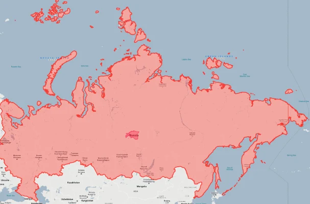
Estonia (highlighted in red) would fit into Russia 378 times! This dramatic contrast shows how severely Mercator projection distorts our perception of size.
Estonia vs. Its Baltic Siblings
Estonia is significantly smaller than its Baltic neighbors, creating an interesting regional size gradient:
- Estonia vs. Latvia: Estonia (45,227 km²) is 30% smaller than Latvia (64,589 km²) despite the two countries often being perceived as similar in size. Latvia could contain 1.4 Estonias within its borders. This size difference appears even more significant when considering that Estonia has approximately 1.3 million residents compared to Latvia’s 1.9 million – creating a significant population density difference (30 people/km² vs. 34 people/km²).
- Estonia vs. Lithuania: The contrast with Lithuania (65,300 km²) is even more dramatic – Estonia is 44% smaller than its southernmost Baltic neighbor. Lithuania could contain almost 1.5 Estonias within its territory. The population difference is even more striking, with Lithuania’s 2.8 million people more than doubling Estonia’s population.
- Baltic Proportions: When looking at the total Baltic territory (175,116 km²), Estonia occupies just 26% of the region, while Latvia holds 37% and Lithuania 37%. This makes Estonia the definitive “little brother” in the Baltic family despite often receiving more international attention due to its technological advancement.
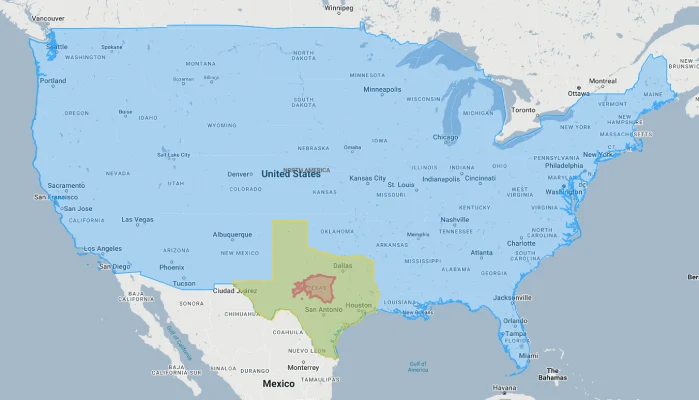
- Baltic Comparison with Texas: All three Baltic states combined (175,116 km²) would fit into Texas nearly 4 times – with Estonia alone fitting into the Lone Star State more than 15 times. This remarkable size comparison highlights how compact the entire Baltic region truly is on a global scale.
Estonia’s Extraordinary Geographic Features
Despite its modest size, Estonia packs remarkable geographical diversity:
- The Island Nation on the Mainland: Estonia’s most distinctive geographical feature is its extraordinary island count – 2,222 islands dot its coast despite the country’s modest dimensions. This creates one of the world’s highest ratios of islands to mainland area. The largest, Saaremaa (2,673 km²), would rank as the world’s 175th largest island and alone constitutes about 6% of Estonia’s entire territory. Remarkably, Estonia has more islands than many famed island nations including the Bahamas (700), Maldives (1,192), and Fiji (332) – all within a country smaller than New Hampshire.
- The Boggy Bottom of Europe: Approximately 22% of Estonia’s limited territory is covered by wetlands and peatlands – one of Europe’s highest percentages. This creates a landscape where approximately 1 in 5 steps would land on a bog, fen, or marsh. The most impressive is Soomaa National Park (so important it’s nicknamed “The Fifth Season”) where annual floods can submerge 175 km² of forest, creating a vast water world navigable only by canoe – a landscape feature typically found only in much larger countries.
- The Lake District in Miniature: Estonia contains 3,794 lakes packed into its compact territory – more per square kilometer than its much larger neighbor Finland, famously known as “The Land of a Thousand Lakes.” The largest, Lake Peipus (3,555 km²), forms much of Estonia’s eastern border with Russia and is Europe’s 5th-largest lake – remarkably constituting nearly 8% of Estonia’s entire territory within a single water body.
- The Meteorite Country: Estonia’s modest territory contains an astonishing concentration of meteorite craters – at least 8 confirmed impact sites including the spectacular Kaali crater. This 110-meter-wide, 22-meter-deep crater on Saaremaa Island was formed approximately 4,000 years ago and is one of the world’s most recent major impact sites. Estonia has more confirmed meteorite craters per square kilometer than any other nation on Earth – an extraordinary geological distinction for such a small country.
Estonia’s Three Distinct Geographic Regions
Despite its compact size, Estonia divides into three distinct geographical zones:
| Region | Area (km²) | Similar Size To | Geographic Character |
|---|---|---|---|
| Northern Coastal Plain | ~15,000 | Connecticut | Limestone cliff coastline (the Baltic Klint) with the capital Tallinn, industrial areas, and smaller islands |
| Central Uplands | ~16,000 | Kuwait | Rolling hills including Estonia’s highest point (Suur Munamägi at just 318m) with lakes, forests, and agricultural areas |
| Western Islands | ~14,000 | Northern Ireland | Archipelago including Saaremaa, Hiiumaa, and thousands of smaller islands with unique ecosystems and cultural traditions |
5 Natural Wonders Packed into Estonia’s Small Territory
1. The Estonian Meteorite Crater Field
Estonia’s Kaali crater field on Saaremaa Island features nine distinct impact craters formed approximately 4,000 years ago when a meteorite shattered upon entering Earth’s atmosphere.
The main crater measures 110 meters across and 22 meters deep, with a small lake at the bottom. This impact was so significant that it likely influenced Estonian and Baltic mythology, potentially inspiring references to “sun falling from the sky” in ancient folklore.
2. The Singing Bogs of Soomaa
Estonia’s Soomaa National Park contains one of Europe’s largest intact peatland ecosystems, where visitors can walk on floating bog islands that actually “sing” when stepped upon due to water movement beneath the surface vegetation.
During the annual spring “fifth season,” melting snow creates a flood covering 175 km² of forest, turning hiking trails into canoe routes through a mystical submerged landscape with treetops poking through reflective waters.
3. The Baltic Klint Waterfalls
Along Estonia’s northern coast runs the Baltic Klint, a limestone escarpment where rivers drop dramatically to the sea, creating the highest waterfall in the Baltic states – the 30.5-meter Jägala Falls.
During winter, these falls transform into a magical ice wall with walkable caves behind the frozen cascade, creating one of Europe’s most accessible ice formations within just a 30-minute drive from the capital city.
4. The Moving Dunes of Rannametsa
In southwestern Estonia, the Rannametsa dunes rise to 35 meters above sea level, forming Estonia’s largest sand dune system that continues to shift and move with coastal winds.
These dunes contain the unique Tolkuse Bog, one of the few places in Europe where a raised bog exists directly adjacent to the sea, creating an extraordinary ecological transition zone from marine to freshwater environments within just a few hundred meters.
5. The Primeval Forest of Alutaguse
Estonia’s eastern border contains the Alutaguse wilderness, the country’s largest contiguous forest area, where European brown bears, wolves, and flying squirrels still roam in significant numbers.
This pristine forest features trees over 150 years old and contains some of Europe’s best-preserved raised bog systems, including Agusalu bog with distinctive ‘islands’ of higher forest surrounded by wetland labyrinths navigable only by wooden boardwalks.
Explore More Size Comparisons
Curious about how other countries compare in true size? Check out these related articles:
- Real Size Of Latvia: Baltic Nation With More Bogs Than People Yet Smaller Than West Virginia
- Real Size Of Lithuania: Baltic Nation Smaller Than West Virginia Yet Home to Europe’s Geographical Center
- Real Size Of Finland: Land of 188,000 Lakes in a Territory Smaller Than Montana
- Real Size Of Russia: The Giant That Would Stretch From San Francisco to London if Moved South
- Complete List of Countries by True Size