Montenegro
World Rank: #156
13,812 km²

Next Larger Country
(Rank #155)
East Timor
14,874 km²
Next Smaller Country
(Rank #157)
Bahamas
13,943 km²
Montenegro: Rugged Balkan Pearl
Montenegro ranks as the 156th largest country in the world with a territory of 13,812 square kilometers (5,333 square miles). Located on the Adriatic coast of the Balkan Peninsula, Montenegro is bordered by Croatia, Bosnia and Herzegovina, Serbia, Kosovo, and Albania, occupying a strategic position between the Mediterranean and the interior Balkans.
What makes Montenegro geographically remarkable is its extraordinary topographical diversity in such a compact area. This small nation packs impressive variety of landscapes into an area roughly the size of Connecticut or Northern Ireland.
Located between latitudes 41° and 44° North, Montenegro experiences minimal distortion on standard Mercator projection maps. The common perception of Montenegro’s size is generally accurate, with its position in southern Europe making it appear proportionally correct on most maps.
Let’s explore how Montenegro’s true size compares to other regions with our interactive map that adjusts for that Mercator projection distortion and gives you the true size of Montenegro:
Watch Montenegro shrink to its actual size as we move it toward the equator. We compare it to the USA, Europe, Africa, Greenland, Brazil, Australia, Russia, India, China, etc. You can use this country size comparison interactive map here.
Montenegro’s True Size in Global Perspective
To better understand Montenegro’s dimensions, direct comparisons with other regions provide valuable context:
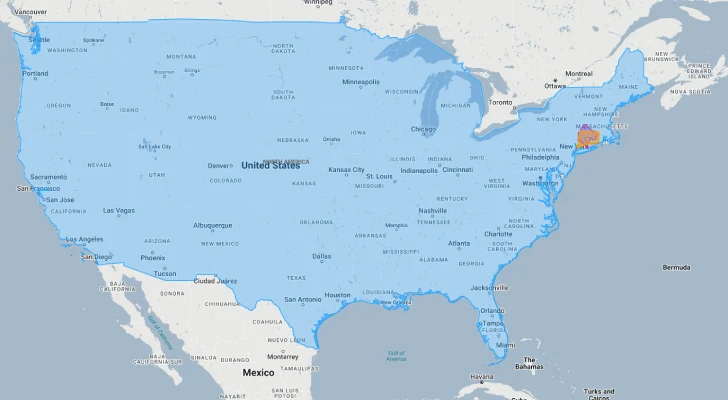
Montenegro vs. US States: Montenegro is similar in size to Connecticut and about 1/30 the size of California
| Comparison | Flag | Area (km²) | Size Relative to Montenegro |
|---|---|---|---|
| Montenegro | |
13,812 | 1.0 |
| Serbia |  |
88,361 | 6.40 times Montenegro’s size |
| Croatia |  |
56,594 | 4.10 times Montenegro’s size |
| Bosnia and Herzegovina |  |
51,209 | 3.71 times Montenegro’s size |
| Albania |  |
28,748 | 2.08 times Montenegro’s size |
| North Macedonia |  |
25,713 | 1.86 times Montenegro’s size |
| Kosovo |  |
10,887 | 0.79 times Montenegro’s size |
| Slovenia |  |
20,273 | 1.47 times Montenegro’s size |
| Connecticut (US state) |  |
14,357 | 1.04 times Montenegro’s size |
| Northern Ireland (UK) |  |
14,130 | 1.02 times Montenegro’s size |
5 Surprising Montenegro Size Comparisons
- Montenegro vs. Serbia: Serbia, with which Montenegro shared a state until 2006, is approximately 6.4 times larger than Montenegro.
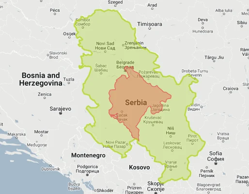
- Montenegro vs. Bosnia and Herzegovina: Bosnia and Herzegovina is about 3.7 times larger than Montenegro – despite both being relatively small Balkan states.

- Montenegro vs. Croatia: Croatia is 4.1 times larger than Montenegro, though both countries share similar Adriatic coastlines.

- Montenegro vs. Slovenia:

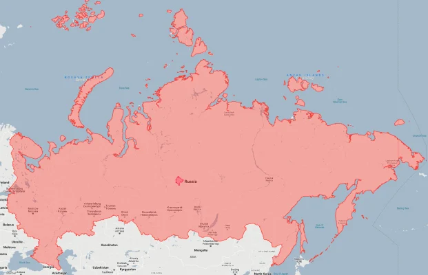
- Montenegro vs. Russia: Russia is approximately 1,236 times larger than Montenegro – the world’s largest country could fit Montenegro more than 1,200 times within its borders.
Montenegro’s Geographic Diversity: Mountains and Coast
Despite its small size, Montenegro contains remarkable geographic diversity, often described as having “wild beauty”:
- Coastal Region: The narrow coastal strip along the Adriatic features dramatic limestone cliffs, the spectacular Bay of Kotor, and beautiful beaches
- Karst Region: The central limestone plateau contains numerous caves, sinkholes, and the largest lake in the Balkans, Lake Skadar (shared with Albania)
- Dinaric Alps: The rugged mountain interior includes deep river canyons, high peaks, and Europe’s last virgin forests
- Highest Peak: Zla Kolata reaches 2,534 meters (8,314 feet) on the border with Albania
- Durmitor National Park: A UNESCO World Heritage site featuring limestone peaks, glacial lakes, and the Tara River Canyon – the deepest canyon in Europe and second deepest in the world after the Grand Canyon
Adriatic Coastline: Small Country, Significant Shore
Montenegro’s coastline is one of its defining geographical features:
- Montenegro has 293.5 kilometers (182.4 miles) of coastline along the Adriatic Sea
- The Bay of Kotor (Boka Kotorska) is Europe’s southernmost fjord-like formation, with steep limestone cliffs rising dramatically from the water
- The coastal strip is extremely narrow in places, with mountains rising steeply from the sea – at some points, you can swim in the sea and see snow-capped peaks simultaneously
- Historic coastal towns like Kotor, Budva, and Herceg Novi preserve their Venetian architectural heritage
- Despite having only about 0.5% of Europe’s coastline, Montenegro has more than 120 beaches along its shores
Tara River Canyon: Europe’s Grand Canyon
The Tara River Canyon represents one of Montenegro’s most spectacular geographical features:
- The Tara Canyon stretches for 82 kilometers (51 miles) and reaches depths of up to 1,300 meters (4,300 feet)
- It is the deepest canyon in Europe and second deepest in the world after the Grand Canyon in the United States
- The canyon is protected as part of Durmitor National Park, a UNESCO World Heritage site
- The crystal-clear Tara River, known as the “Tear of Europe” due to its exceptional water quality, carves through the canyon
- The Đurđevića Tara Bridge spans the canyon at a height of 172 meters (564 feet), offering spectacular views
Population Distribution: One of Europe’s Least Densely Populated Countries
Montenegro’s population pattern reflects its challenging topography:
- With approximately 620,000 people, Montenegro has an average population density of about 45 people per square kilometer, one of the lowest in Europe
- Population is concentrated in the coastal region and in the relatively flat area around the capital Podgorica
- Podgorica, the capital, hosts about 185,000 residents in its urban area, roughly 30% of the country’s total population
- The mountainous northern regions are sparsely populated, with some municipalities having fewer than 10 people per square kilometer
- Unlike many European countries, Montenegro has several towns with historical significance that are more prominent in cultural terms than their populations would suggest (e.g., Cetinje, the former royal capital)
Montenegro’s Administrative Divisions: Small But Varied
Montenegro’s administrative organization divides its compact territory into 24 municipalities:
| Municipality | Area (km²) | Comparable Area |
|---|---|---|
| Nikšić (largest) | 2,065 | Luxembourg (2,586 km²) |
| Pljevlja | 1,346 | Sao Tome and Principe (964 km²) |
| Podgorica (capital) | 1,441 | County of Rutland, UK (382 km²) |
| Kotor | 335 | Malta (316 km²) |
| Tivat (smallest) | 46 | San Marino (61 km²) |
Climate and Geography: Mediterranean Meets Alpine
Montenegro’s varied topography creates distinct climate zones within short distances:
- The country has two primary climate zones: Mediterranean climate along the coast and continental climate in the mountainous interior
- The coastal region experiences hot, dry summers and mild, rainy winters, with Podgorica being one of Europe’s hottest capitals in summer
- Mountain regions have cold winters with substantial snowfall and cool summers
- Montenegro receives abundant precipitation, with Crkvice in the mountains recording Europe’s highest rainfall average at over 4,600mm (181 inches) annually
- Despite being just 80km (50 miles) from the coast, the northern mountains can be snowbound for up to six months of the year
Strategic Position: Gateway to the Adriatic
Montenegro’s compact size belies its historical strategic importance:
- Montenegro shares 680 kilometers (423 miles) of land borders with five countries or territories: Croatia, Bosnia and Herzegovina, Serbia, Kosovo, and Albania
- The Bay of Kotor provides one of the finest natural harbors in the Mediterranean, historically coveted by various naval powers
- Montenegro’s mountainous terrain historically provided natural defenses, allowing it to resist Ottoman conquest more successfully than most Balkan regions
- The Montenegrin coast lies at the entrance to the Adriatic Sea, giving it strategic significance through naval history
- Despite its small size, Montenegro was the only Balkan nation to maintain de facto independence during most of the Ottoman period
Natural Resources: Waters, Forests and Minerals
Montenegro’s varied landscape provides several valuable natural resources:
- Forests cover approximately 60% of Montenegro’s territory, making it one of Europe’s most forested countries
- Water resources are abundant, with numerous rivers, lakes, and a significant coastline
- Mineral resources include bauxite, lead, zinc, coal, salt, and limestone for construction
- Hydropower potential is significant due to mountainous terrain and abundant rainfall
- The country has valuable tourism resources in its combination of pristine beaches, historic towns, and dramatic mountain landscapes
Environmental Protection: From “Ecological State” to Development Challenges
Montenegro’s approach to its natural environment is notable but evolving:
- In 1991, Montenegro officially declared itself an “Ecological State”, constitutionally committing to environmental protection
- The country has five national parks protecting approximately 10% of its territory
- Durmitor National Park and the Natural and Cultural-Historical Region of Kotor are both UNESCO World Heritage sites
- Rapid coastal development in recent decades has created tension between tourism growth and environmental protection
- Lake Skadar, the largest lake in the Balkans, is a Ramsar wetland of international importance, hosting over 270 bird species
Explore More Size Comparisons
Curious about how other Balkan countries and major nations compare in true size? Check out these related articles:
- The True Size of Serbia
- The Real Size of Croatia
- The Real Size of Albania
- Complete List of Countries by True Size
Sources & Further Reading
- Statistical Office of Montenegro (MONSTAT). (2024). Geographic and Demographic Data.
- CIA World Factbook. (2024). Montenegro.