Greece
World Rank: #95
131,957 km² (50,949 sq mi)


Next Larger Country
(Rank #94)
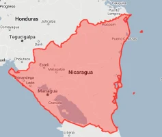
Nicaragua
130,373 km² (50,337 sq mi)
Next Smaller Country
(Rank #96)
South Korea
100,210 km² (38,691 sq mi)

Greece: The Ancient Nation with More Coastline Than Africa
Did you know that Greece – the birthplace of Western civilization – has a longer coastline than all of Africa despite being the size of a single U.S. state? Or that this Mediterranean country controls over 6,000 islands while having a mainland smaller than Mississippi?
Welcome to the surprising dimensions of Greece – a country whose geographical footprint is dramatically expanded by its extraordinary maritime presence. Ranking 95th globally with just 131,957 square kilometers (50,949 square miles) of territory, Greece is approximately half the size of the United Kingdom or roughly equivalent to Alabama. Yet this modest-sized nation controls some of the Mediterranean’s most strategic waters and islands.
In this article, we’ll drag Greece across the map to reveal how this Aegean nation truly measures up against other countries. Located between 34°N and 42°N latitude, Greece experiences minimal map distortion on standard projections, meaning the Greece you see on maps is relatively accurate in size – but its fragmented, archipelagic nature often makes its full extent difficult to appreciate.
Despite its moderate dimensions, Greece packs extraordinary geographic diversity into its territory, stretching from the Pindus Mountains through the Thessalian plains to the countless islands dotting the Aegean and Ionian Seas. The country’s remarkably complex shoreline stretches an astonishing 13,676 kilometers (8,498 miles) – longer than the entire coastline of India despite Greece having just 3% of India’s land area!
Here is how big Greece actually is (video made with our interactive tool that adjusts for Mercator projection distortion):
Watch how Greece compares when overlaid on other countries. We’ve moved it across the USA, Western Europe, Australia, and many other nations to reveal its true proportions. You can use this country size comparison interactive map here.
7 Mind-Blowing Greece Size Facts
- Greece has 13,676 km of coastline – longer than the entire continent of Africa (26,000 km) despite having just 0.44% of Africa’s land area
- Greece is smaller than Louisiana but contains more islands than the entire Caribbean
- Greece is only 54% the size of the United Kingdom yet has 41% more coastline
- Greece’s mainland is roughly the same size as Mississippi (125,438 km²), but its thousands of islands extend its territory considerably
- Greece’s Exclusive Economic Zone is nearly 5 times larger than its land area at approximately 505,600 km²
- Greece is 35 times smaller than Australia but has a longer coastline
- If Greece were in the U.S., it would rank as the 31st largest state, between Mississippi and Alabama
Greece’s True Size in Global Perspective
To appreciate Greece’s actual dimensions, these direct comparisons with familiar regions offer eye-opening context:

Greece vs. United Kingdom: Greece is approximately 54% the size of the UK (131,957 km² vs. 242,495 km²)
| Comparison | Flag | Area (km²) | Size Relative to Greece |
|---|---|---|---|
| Greece | |
131,957 | 1.0 |
| United Kingdom |  |
242,495 | 1.84 times Greece’s size |
| Nicaragua | |
130,373 | 0.99 times Greece’s size |
| Mississippi (US state) |  |
125,438 | 0.95 times Greece’s size |
| South Korea | |
100,210 | 0.76 times Greece’s size |
| Portugal |  |
92,212 | 0.70 times Greece’s size |
| Iceland |  |
103,000 | 0.78 times Greece’s size |
6 Astonishing Greece Size Comparisons
- Greece vs. United Kingdom: Greece (131,957 km²) is approximately 54% the size of the United Kingdom (242,495 km²), yet has a significantly longer coastline due to its countless islands and jagged mainland shores. Despite having roughly half the UK’s land area, Greece’s extraordinary 13,676 kilometers of coastline dwarfs the UK’s 12,429 kilometers.
- Greece vs. American States: Greece is almost exactly the same size as Mississippi (125,438 km²) or Alabama (135,767 km²). If placed over the eastern United States, Greece would cover roughly the distance from Washington D.C. to Charlotte, North Carolina – a substantial area but far smaller than many Americans might assume given Greece’s outsized historical and cultural significance.

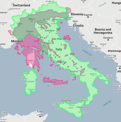
- Greece vs. Mediterranean Neighbors: Greece is approximately 44% the size of Italy (301,340 km²) and 26% the size of Spain (505,990 km²), making it one of the smaller Mediterranean nations despite its prominence. However, Greece controls more islands than both countries combined and has a longer coastline than either, demonstrating how Greece’s effective maritime presence exceeds its modest land area.
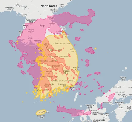
- Greece vs. South Korea: Greece is about 32% larger than South Korea (100,210 km²), though South Korea packs more than five times Greece’s population into its smaller territory. This stark contrast in population density (South Korea: 527 people/km² vs. Greece: 82 people/km²) highlights the different development patterns between these two peninsula-dominated countries with similar coastal orientations.
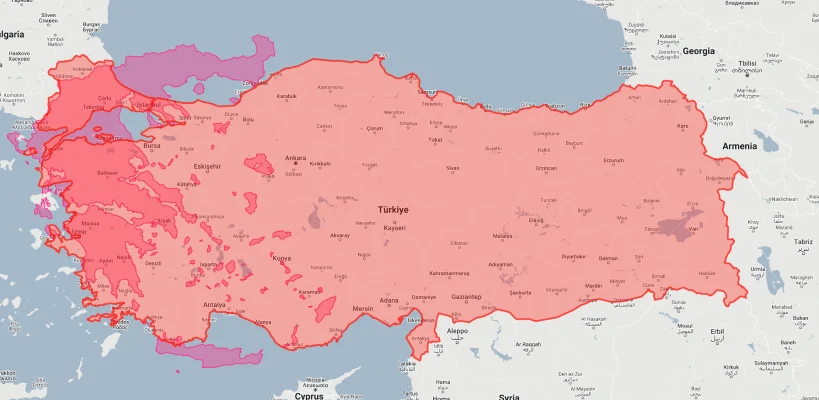
- Greece vs. Turkey:
- Greece vs. Spain:

The Greek Paradox: Maximum Maritime Influence from Minimal Territory
How has Greece leveraged its modest territory into such extraordinary influence?
The Archipelagic Advantage
Greece’s territorial footprint is dramatically expanded by its 6,000+ islands and islets, of which approximately 227 are inhabited. This archipelagic nature creates the remarkable situation where Greece—with mainland dimensions similar to Mississippi—controls a maritime domain nearly 5 times its land area. The strategic distribution of these islands across the Aegean and Ionian Seas historically gave Greece control over critical Mediterranean shipping lanes and trade routes.
The Coastline Effect
Greece possesses one of the world’s most extraordinary coastline-to-area ratios at approximately 1 kilometer of coast per 9.6 square kilometers of territory. This creates an exceptional maritime orientation, with no point in Greece more than 85 kilometers from the sea. This coastal advantage facilitated the development of Greek maritime trade, naval power, and cultural diffusion that vastly exceeded what would be expected from a nation of Greece’s modest size.
The Geographical Crossroads
Greece occupies a pivotal position at the intersection of Europe, Asia, and Africa—three continents whose cultural exchanges have shaped world history. This crossroads position at the nexus of major civilizations allowed Greece to serve as a cultural bridge and trading hub despite its limited territorial dimensions. Athens lies just 250 kilometers from Turkish shores, creating a natural connection point between Europe and Asia.
The Cultural Magnification
Greece’s extraordinary cultural and historical legacy—from Homeric epics to classical philosophy, democratic governance to architectural innovation—has created a “psychological size effect” where Greece looms larger in global consciousness than its physical dimensions would suggest. This cultural footprint, established during ancient Greece’s golden age and reinforced through subsequent European intellectual traditions, gives Greece outsized recognition despite ranking just 95th in global land area.
Greece’s Geographic Diversity: Extraordinary Variety in Limited Space
Greece packs remarkable landscape diversity into its modest territory:
- Mountains Dominate: Despite its reputation for islands and coastlines, Greece is actually one of Europe’s most mountainous countries, with approximately 80% of its territory classified as mountainous or hilly. The Pindus range forms the “spine” of mainland Greece, with peaks reaching 2,918 meters (9,573 feet) at Mount Olympus – mythological home of the Greek gods. This mountain-dominated geography creates dramatic topographic diversity within a relatively compact national framework.
- Unparalleled Island Universe: Greece controls approximately 6,000 islands and islets, of which only 227 are inhabited. This creates the highest island-to-mainland ratio of any country globally, with islands comprising approximately 19% of Greece’s total territory (about 25,000 km²). The island of Crete alone (8,336 km²) is larger than the U.S. state of Delaware, while the island cluster of the Cyclades contains 33 major islands within a sea area of just 14,000 km² – creating one of Earth’s densest island concentrations.
- Peninsular Complexity: Mainland Greece features extraordinary peninsular complexity, with the Peloponnese peninsula nearly separated from the mainland by the 6.3-kilometer Corinth Canal. The three-pronged Chalkidiki Peninsula extends into the Aegean with finger-like projections, while numerous smaller peninsulas create Greece’s remarkably jagged coastline. This peninsular character means that no point in Greece is more than 85 kilometers from the sea – a degree of maritime proximity matched by few nations.
- Biodiversity Hotspot: Despite occupying just 0.09% of Earth’s land surface, Greece hosts more than 6,600 plant species (approximately 25% of which are endemic), 116 mammal species, 240 bird species, and 102 reptile and amphibian species. This makes Greece one of Europe’s richest biodiversity centers – a function of its varied topography, complex coastline, numerous islands creating isolation effects, and position at the crossroads of European, Asian, and African biomes.
- Remarkable Coastline: Greece’s 13,676-kilometer (8,498-mile) coastline is the 11th longest globally despite the country ranking just 95th in area – creating one of the world’s highest coastline-to-area ratios at 1 kilometer of coast per 9.6 square kilometers of territory. For comparison, this ratio is almost 15 times higher than the United States, where the figure is 1 kilometer of coast per 141 square kilometers of territory. This coastal complexity creates countless bays, coves, and natural harbors that historically facilitated maritime commerce and naval development.
Greece’s Regions: Geographic Diversity
Greece is divided into 13 administrative regions encompassing both mainland and island territories:
| Greek Region | Area (km²) | Comparable To | Major City |
|---|---|---|---|
| Central Macedonia (largest region) |
18,811 | Slightly smaller than Israel (20,770 km²) | Thessaloniki |
| Crete (largest island) |
8,336 | Larger than Cyprus (9,251 km²) | Heraklion |
| Attica (includes Athens) |
3,808 | Similar to Rhode Island (4,001 km²) | Athens |
| South Aegean (island region) |
5,286 | Similar to Trinidad and Tobago (5,130 km²) | Rhodes |
| Ionian Islands | 2,307 | Similar to Luxembourg (2,586 km²) | Corfu |
| Epirus (northwestern region) |
9,203 | Similar to Cyprus (9,251 km²) | Ioannina |
| North Aegean (island region) |
3,836 | Similar to Rhode Island (4,001 km²) | Mytilene |
Population Distribution: Concentrated in Limited Space
Greece’s 10.4 million inhabitants are distributed with notable patterns across its limited territory:
- With approximately 10.4 million residents, Greece maintains a moderate population density of 82 people per square kilometer (212 per square mile) – lower than most Western European countries but concentrated in specific areas due to the country’s mountainous terrain.
- Greece shows dramatic population concentration, with the Athens Metropolitan Area containing approximately 3.75 million people – around 36% of the entire country’s population within just 2.9% of its territory. This creates the most pronounced urban primacy in the European Union, with Athens having nearly 6.5 times more residents than Greece’s second-largest city, Thessaloniki (approximately 790,000).
- The population is heavily coastal, with approximately 85% of Greeks living within 50 kilometers of the sea. This coastal concentration creates a distinctive ribbon-like settlement pattern around much of the Greek mainland and dominant coastal development on most inhabited islands.
- Despite having over 6,000 islands, only 227 are inhabited, and just 78 have more than 100 permanent residents. Island populations range from Crete’s 650,000 residents to many islands with fewer than 50 year-round inhabitants. This creates stark seasonal population fluctuations, with some tourist islands seeing their populations expand by more than 1,000% during summer months.
- Mountain villages throughout Greece have experienced significant depopulation, with many interior settlements losing over 50% of their populations since 1950. This has created a demographic hollowing-out of Greece’s mountainous interior, which comprises approximately 80% of the country’s land area but contains a diminishing portion of its population.
Maritime Dominance: A Nation Defined by the Sea
Greece’s relationship with the sea shapes its national identity and territorial footprint:
- Island Nation Reality: Greece controls approximately 6,000 islands and islets scattered across the Aegean and Ionian Seas, though only 227 are inhabited. This creates an extraordinary situation where islands constitute roughly 19% of Greece’s total land area (about 25,000 km²) – the highest proportion of island territory to total land area of any country in Europe and among the highest globally.
- Maritime Territory: Greece’s Exclusive Economic Zone (EEZ) covers approximately 505,600 square kilometers – nearly 4 times larger than its land territory. This creates a situation where Greece’s effective maritime footprint vastly exceeds its modest land area, giving the country control over crucial shipping lanes and marine resources disproportionate to its ranking as the world’s 95th largest nation by land area.
- Shipping Superpower: Despite its modest size, Greece controls the world’s largest merchant fleet with Greek-owned vessels representing approximately 21% of global shipping capacity. This maritime dominance stems from Greece’s strategic position and seafaring tradition, creating an economic footprint that vastly exceeds what would be expected from a nation with Greece’s limited territorial dimensions.
- Coastal Complexity: Greece’s 13,676-kilometer coastline creates one of the world’s highest coastline-to-area ratios at approximately 1 kilometer of coast per 9.6 square kilometers of territory. This extraordinary coastal complexity creates countless natural harbors and bays, facilitating the development of shipping, fishing, and tourism industries that form the backbone of the Greek economy.
- Strategic Waterways: Greece controls key portions of the Mediterranean’s eastern basin, including strategic passages like the Dardanelles approach and routes connecting the Eastern Mediterranean to Western Europe. This maritime position has historically given Greece influence exceeding its terrestrial dimensions, with the country effectively functioning as a “maritime crossroads” between Europe, Asia, and Africa.
Topographic Challenges: A Mountainous Nation
Greece’s rugged terrain creates distinctive challenges within its modest territory:
- Mountain Dominance: Approximately 80% of Greece consists of mountains or hills, with the Pindus range forming a “spine” running north-south through the mainland. This mountainous character has historically isolated communities and complicated infrastructure development, with many mountain villages remaining difficult to access. Despite accounting for 80% of Greece’s territory, these mountainous regions contain less than 20% of the population.
- Limited Arable Land: Greece’s mountain-dominated terrain leaves just 19% of the national territory suitable for cultivation – one of the lowest percentages in Europe. This limited agricultural base (approximately 25,000 km²) creates a distinctive challenge for a country with Greece’s population size, contributing to its historical reliance on maritime trade and, more recently, food imports.
- Infrastructure Challenges: Greece’s combination of mountainous terrain, numerous islands, and complex coastline creates significant infrastructure challenges. The country’s road network must navigate difficult mountain terrain, while fully connecting its inhabited islands requires an extensive ferry system spanning 230 destinations. Maintaining transportation links across this fragmented geography costs approximately 2-3 times more per capita than in less geographically complex European nations.
- Natural Hazard Vulnerability: Greece’s position along the boundary between the African and Eurasian tectonic plates makes it Europe’s most seismically active country, with approximately 50% of European earthquake activity occurring within Greek territory. This seismic risk, combined with flash flood vulnerability in mountain valleys and wildfire risks in dry summers, creates complex natural hazard management challenges within Greece’s limited territorial footprint.
- Frontier Management: Greece’s complex geography creates challenging border management requirements, with the country maintaining both land borders with four countries (Albania, North Macedonia, Bulgaria, and Turkey) and extensive maritime boundaries requiring monitoring and patrol across thousands of islands and islets. This creates border control requirements vastly disproportionate to Greece’s modest territorial dimensions.
Historical Significance: Legacy Exceeding Size
Greece’s impact through history vastly exceeds its physical dimensions:
- Density of Heritage: Despite occupying just 0.09% of Earth’s land surface, Greece contains 18 UNESCO World Heritage Sites – creating one of the world’s highest concentrations of globally recognized cultural treasures per square kilometer. This extraordinary density of archaeological and historical sites means Greece averages one World Heritage site per 7,330 square kilometers compared to a global average of one per 72,500 square kilometers.
- Classical Legacy: From a territorial base approximately the size of Alabama, ancient Greece produced philosophical traditions, democratic governance concepts, architectural forms, literary works, and scientific approaches that fundamentally shaped Western civilization. This remarkable cultural output from such limited geography created an influence-to-area ratio perhaps unmatched in human history.
- Literary Impact: Greece’s literary tradition, beginning with Homer’s epics around the 8th century BCE, spans nearly 3,000 years of continuous written culture – the longest of any European nation. This extraordinarily deep literary heritage from such limited geography includes works that established fundamental forms and themes still dominant in Western literature.
- Maritime Empire: At its peak around 450 BCE, the Athenian Empire controlled approximately 200,000 square kilometers of territory and dominated the eastern Mediterranean despite originating from an Attica region of just 3,808 square kilometers – creating an empire more than 50 times larger than its core territory. This remarkable amplification of influence through maritime power demonstrates how Greece historically leveraged its limited territorial base.
- Diaspora Influence: Beyond its physical borders, Greece maintains a globally significant diaspora estimated at 5-7 million people – nearly matching the current population within Greece itself. This creates a situation where Greek cultural influence extends far beyond the country’s modest territorial dimensions, with significant Greek communities established from Melbourne to Montreal, Chicago to Munich.
Border Contexts: Compact Nation at the Crossroads
Greece’s position and boundaries create distinctive international relationships:
- Greece shares a 1,110-kilometer (690-mile) land border with four countries: Albania (282 km), North Macedonia (234 km), Bulgaria (494 km), and Turkey (206 km). This creates a relatively short land border compared to Greece’s extensive coastline, with the country having 12.3 times more coastline than land borders – one of the highest such ratios globally.
- The country’s maritime boundaries are far more extensive than its land borders, with Greece sharing maritime boundaries with six nations: Turkey, Egypt, Libya, Italy, Cyprus, and Albania. These maritime frontiers create complex delimitation challenges, particularly in the Aegean Sea where thousands of Greek islands lie in close proximity to the Turkish mainland.
- Greece’s position at the southeastern edge of the European Union makes it a crucial frontier state, with its land and sea borders forming approximately 13% of the EU’s external boundary. This frontier position creates particular migration management challenges, with Greece processing over 1.2 million irregular crossings during the 2015-2016 migration crisis – a major burden for a country with Greece’s modest territorial and population dimensions.
- The shortest distance between Greece and Africa is just 257 kilometers (160 miles) from Crete to Libya across the Mediterranean, while Greece’s easternmost islands lie just 1.9 kilometers (1.2 miles) from the Turkish mainland. This proximity to three continents creates a distinctive crossroads position with strategic importance far exceeding Greece’s modest size.
- Despite modern Greece’s relatively compact dimensions, the country has shrunk significantly from its maximum historical extent. Modern Greece occupies just 40% of the territory populated by Greek-speaking communities in the early 20th century, following population exchanges with Turkey and territorial adjustments after World War I that dramatically reduced the Greek geographical footprint in the Eastern Mediterranean.
Explore More Size Comparisons
Curious about how other major countries and regions compare in true size? Check out these related articles:
- Real Size Of Italy: Only Half The Size Of Philippines But Controls 13th Longest Coastline
- Real Size Of Spain: Much Larger Than California But Smaller Than Texas
- Real Size Of Croatia: Tiny Nation With Spectacular 5,835 km Coastline
- Real Size Of Turkey: Transcontinental Nation Straddling Europe And Asia
- Complete List of Countries by True Size
Sources & Further Reading
- Hellenic Statistical Authority. (2024). Geographical Information and National Statistics.
- Geographical Service of the Hellenic Army. (2023). Physical Geography of Greece.
- Ministry of Environment and Energy. (2024). Greek Environmental Data.
- CIA World Factbook. (2024). Greece.